Yellowpoint Bog ER #139 Overview: Biological and Physical

ORIGINAL PURPOSE To protect a highly diverse mosaic of ecosystem types from aquatic, peat bog and forest to dry-site ecosystems. Physical: The reserve comprises gently undulating lowlands formed by glacially scoured rocks of the cretaceous Nanaimo Formation. For the most part the cover of surficial deposits and soils on the NW-SE trending, rounded ridges is

Katherine Tye ( Vedder Crossing) Er #116 Overview: Biological and Physical

ORIGINAL PURPOSE To protect a population of the very rare Austin’s phantom orchid Physical: The reserve is located on a ridge formed by remnants of a major body of inter- and post-glacial outwash. The southern one third has steep, eroding slopes facing the Chilliwack River valley and the remainder slopes gently towards the Fraser Valley

Blue/Dease River ER #58 Overview: Biological and Physical

Original Purpose: To establish a research area containing a variety of communities in the Boreal White and Black Spruce Zone. Physical:: The reserve lies on a plain of low relief in the Liard River drainage. Micro-relief is provided by many glacial features, oriented in an east-west direction, including eskers, drumlins and morainal landforms. These show

Cleland Island ER overview

CLELAND ISLAND OVERVIEW  BC Parks Date established:4 May 1971 ORC #3001: Map number:92 E/1 Total Area: Land:7.7 ha 7.7 ha Access:Closed to public. A permit is required to land on island. Accessible by water. Biogeoclimatic Zones: Coastal Western Hemlock (CWH) Biogeoclimatic Variant: CWH vh1 CWH Southern Very Wet Hypermaritime Ecosection: Vancouver Island Shelf Region:Vancouver Island

Charlie Cole Creek Overview: Biological and Physical

ORIGINAL PURPOSE To preserve three cold-water mineral springs, associated landforms, and vegetation, on the Kawdy Plateau Physical: This reserve, the only protected area located in the BC portion of the Yukon River basin, features three cold-water mineral springs, a rather unique phenomenon in northern British Columbia. Of the three springs, one is most conspicuous, having

IBA Anthony Island ER #95

 FROM: http://www.ibacanada.com/site.jsp?siteID=BC010&lang=EN IBA Anthony Island Queen Charlotte Islands, British Columbia Site Summary BC010 Latitude Longitude 52.096° N 131.222° W Elevation Size 0 – 75 m 110.32 km² Habitats: coniferous forest (temperate), scrub/shrub Land Use: Not Utilized (Natural Area) Potential or ongoing Threats: Disturbance, Introduced species, Oil slicks IBA Criteria: Globally Significant: Congregatory Species, Colonial Waterbirds/Seabird

IBA Kotcho Lake

From: http://www.ibacanada.com/site.jsp?siteID=BC246&seedet=Y IBA Kotcho lake Fort Nelson, British Columbia Site Summary BC246 Latitude Longitude 59.084° N 121.127° W Elevation Size 0 m 256.17 km² Habitats: freshwater lake, freshwater marsh Land Use: Fisheries/aquaculture Potential or ongoing Threats: Extraction industry IBA Criteria: Nationally Significant: Waterfowl Concentrations Conservation status: Site Description Kotcho Lake is situated in the northeastern

IBA Chain Islets and Great Chain Birds ( ER# 94)

From: http://www.bsc-eoc.org/iba/site.jsp?siteID=BC045 IBA Chain Islets & Great Chain Islet Victoria, British Columbia Site Summary BC045 Latitude Longitude 48.42° N 123.269° W Elevation Size 0 – 5 m 1.38 km² Habitats: scrub/shrub, sedge/grass meadows, mud or sand flats (saline), open sea, coastal cliffs/rocky shores (marine), rocky flats & barrens Land Use: Nature conservation and research Potential

IBA Moore and Byers Islands

http://www.ibacanada.com/site.jsp?siteID=BC106&lang=EN IBA Moore and Byers Islands and Banks Bella Bella, British Columbia Site Summary BC106 Latitude Longitude 52.568° N 129.34° W Elevation Size 0 – 60 m 799.44 km² Habitats: coniferous forest (temperate), coastal sand dunes & beaches, inlets/coastal features (marine), coastal cliffs/rocky shores (marine), other Land Use: Not Utilized (Natural Area) Potential or ongoing

Cougar Canyon E.R. 108 Warden’s report 1999/2000

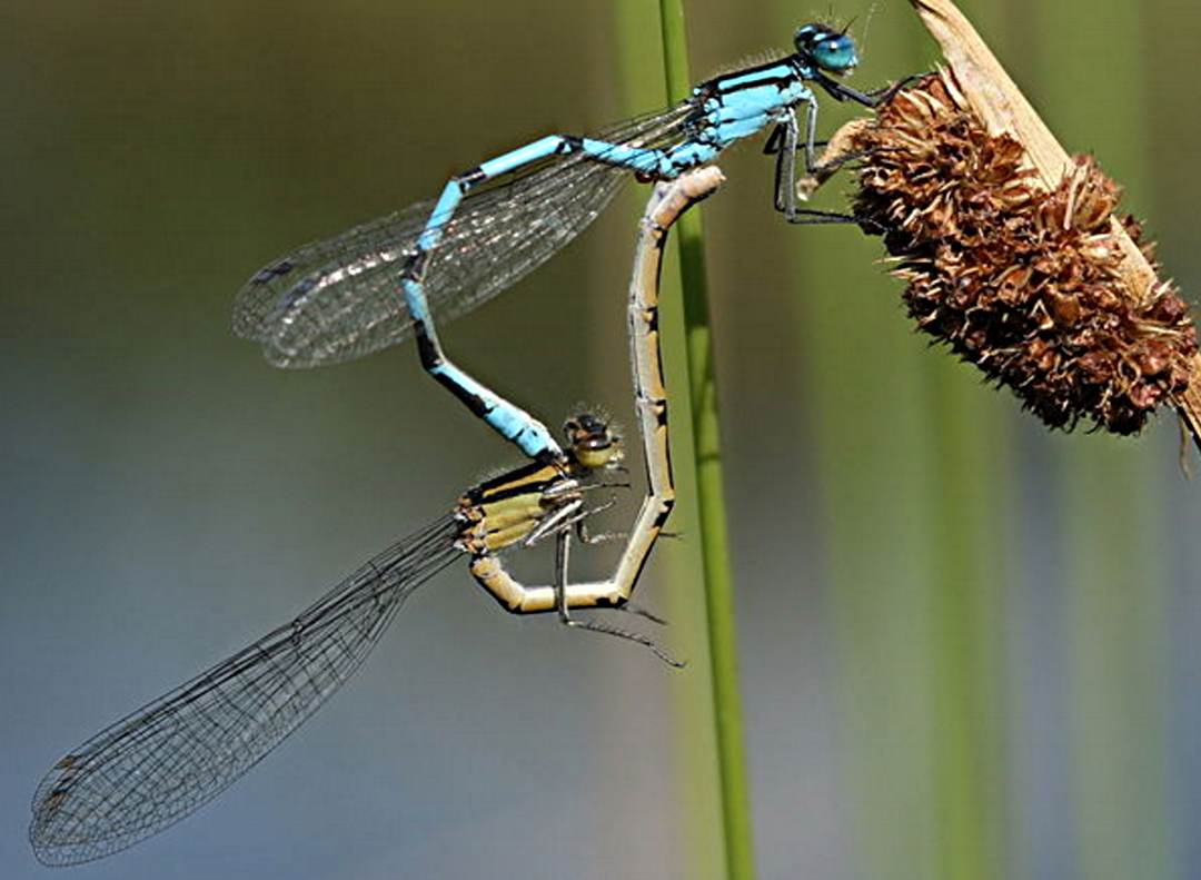
COUGAR CANYON ECOLOGICAL RESERVE – E.R. 108 ANNUAL REPORT 1999/2000 Management and Visits 99.04.16 South end check. Recent fireplace use just outside reserve on east side of Lake 11. Check of salamander trap boards put out in previous October. 99.05.24          South end. Dragonfly survey. 99.06.18 South end. Dragonfly survey. Image of   Enallagma cyathigerum, one of

Torkelson Lake Ecological Reserve Biological and Physical Overview

From the BC Parks Website. ORIGINAL PURPOSE To retain an accessible northern bog-forest complex for research and educational uses See the Full PDF:Torkelsen Lake ER 73 Physical: This reserve is on flanked by mountains rising to 1200 m or higher. Except for a hill on its western side, most of the reserve is flat and

MacKinnon Esker ER #36– Biological and Physical Overview

ORIGINAL PURPOSE To protect a segment of the longest known esker in British Columbia and vegetation types characteristic of eskers. Physical: The central feature of this reserve is a superb segment of the Mackinnon compound esker, a sinuous ridge reported to be over 50 km long, the longest such landform in the province. The esker

Ballingall Islets ER #151 Overview

ORIGINAL PURPOSE To preserve nesting sites of colonial seabirds Physical: This small rocky archipelago is comprised of two islets that are made up of glaciated and wave-worn sedimentary bedrock of the Nanaimo Group, and are oriented in a northwest-southeast direction located between Saltspring and Galiano islands in the Trincomali Channel. These semi-protected islets are barren

Baeria Rocks Overview

Closed to the public by Order-in-Council no. 1920, 16 June 1977 to protect nesting birds which are very vulnerable to disturbance. A permit is required to land on the rocks and they are accessible by boat. Physical: The terrestrial part of the reserve consists of two low bedrock islands 500 m apart, the southern of