


Overview Ilgachuz Range To preserve extensive and diverse alpine-subalpine ecosystems in an isolated massif of volcanic origin
Original Purpose: To preserve extensive and diverse alpine-subalpine ecosystems in an isolated massif of volcanic origin Physical: The Ilgachuz Range is one of three distinct mountain masses which lie within the confines of the Fraser Plateau in the Anahim Lake area. All were formed by shield volcanoes of Miocene age which built up dome-like piles

Lac du Bois Crown land Plan
wildlife management area above Kamloops Lake Waterfowl management, research Area, Includes maps. lac_du_bois_dewdrop_crown_land_plan Photo by Garry Fletcher ( ducks unlimited!!)
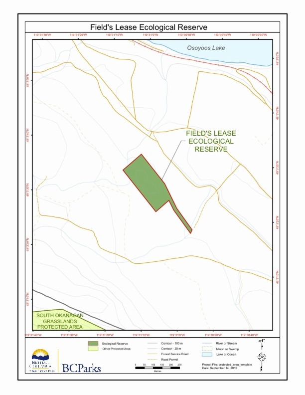
Field’s Lease ER #33 Maps
Two maps adapted from the BC Parks Website
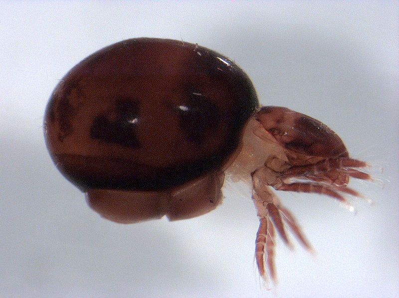
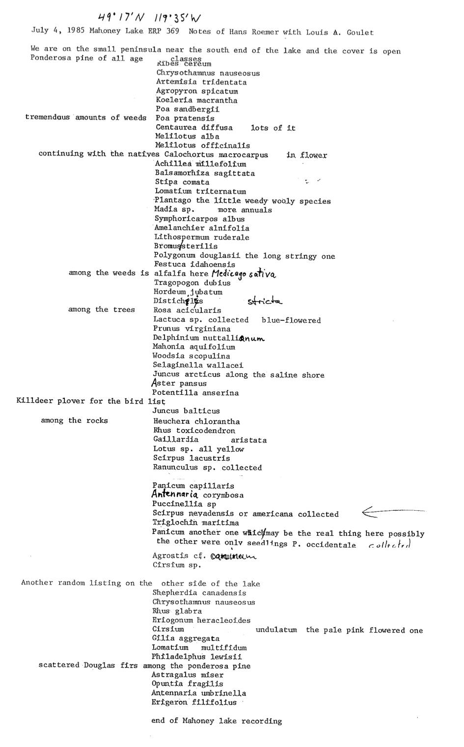
Oribatid Mites ( Acari: orbatida) of Hayne’s Lease ER
Valerie M. Behan-Pelletier of Biosystematics Research Centre , Agriculture Canada, Ottawa did this research in the 1980s. Oribatida are a quantitatively important component of most soils. They affect litter decomposition by feeding on and dispersing fungi, and by stimulating senescent fungal colonies through grazing. See the PDF: oribatid_mites_of_haynes_lease It notes that two generas were found
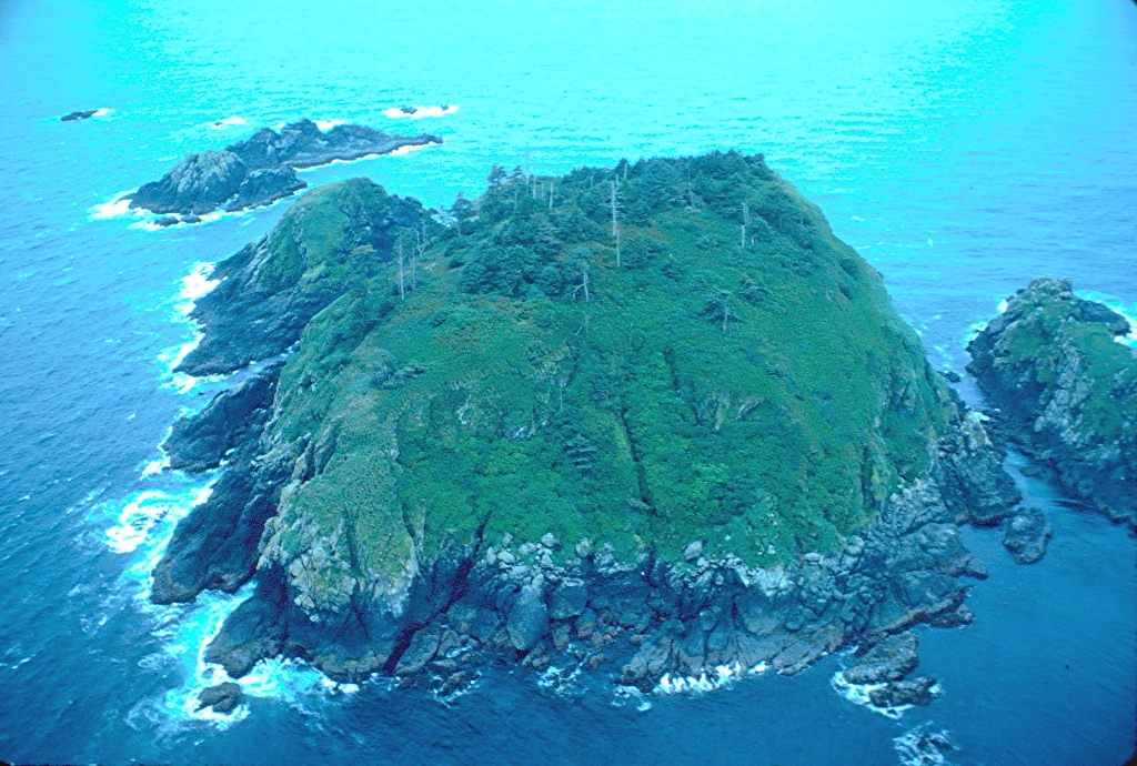
Beresford Island ER #12 Overview: Physical and Biological
Original Purpose: To protect colonies of nesting seabirds and their habitat Physical: A small, rocky island, roughly oval in shape, which rises steeply from deep water to a rounded top. The shore is rock and the upper slopes tend to have less soil cover than Triangle and Sartine islands. A number of rocks and reefs
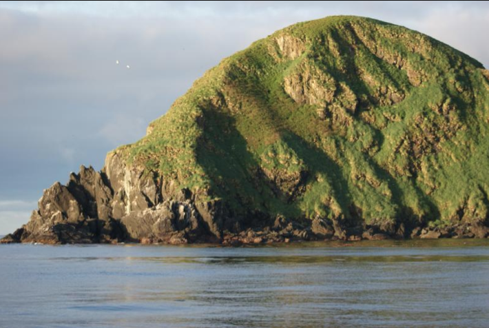
Sartine Islands Ecological Reserve Ecological Overview, Physical and Biological
Original Purpose: To protect colonies of breeding seabirds and their habitat Physical: This is a rugged, elongate island which rises steeply from the sea to a series of pinnacles and humps. The shoreline is rock, rising directly from the water, except for a narrow boulder beach along the northeastern shore. Though steep, most of the
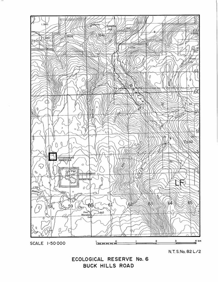
Buck Hills Road map
A topographic map of Buck Hills Road Ecological Reserve.

New Species of Oligochaetes from Kerouard and Anthony Islands : Randy Baker
Several species new to science of the class Oligochaeta were sampled in the Queen Charlotte Islands (Haida Gwaii) by Randy Baker in 1980. His samples were from the West side of Anthony Island in the mid-intertidal sediment , and on Kerourd Island from near the the south west side of St. James Island. See the

Detailed map of Anthony Island reserve
A map showing the location of Anthony Islets reserve in relation to the other parts of Haida Gwaii
Alpine Plant Communities of British Columbia : 1980
1980 Alpine Plant Communities of British Columbia and Their Occurrence in Existing or Proposed Ecological Reserves by George W. Douglas, Douglas Ecological Consultants Ltd. Link to report, 1980 Alpine Plant Communities. Alpine vegetation in British Columbia has received little attention from scientists and land managers. Unfortunately, most of the work that has been done remains

The sea Otter in BC: A Problem or Opportunity
A.C.M. Farr and F.L. Bunnel report presented to a Symposium on Threatened Species and habitats in March 1980. History is also presented. See PDF: sea_otter_in_bc_problem_opportunity
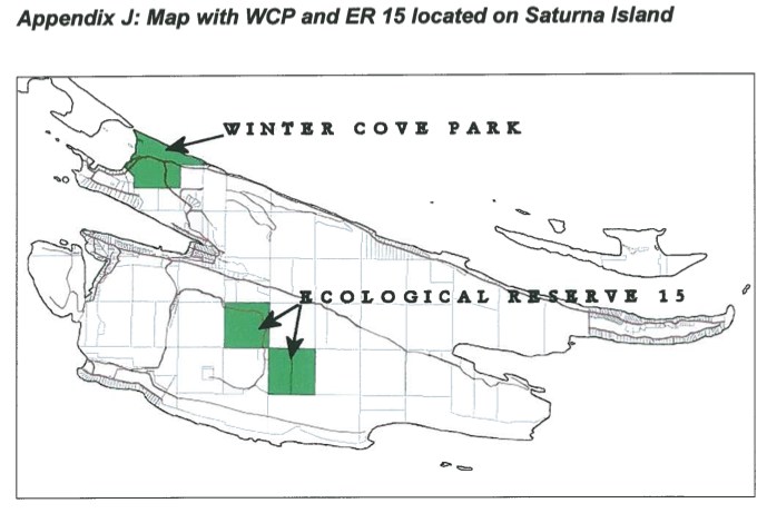
Map of ER #15 Saturna Island
Map showing the location of research plots for the Fungi study by by Janszen 2001
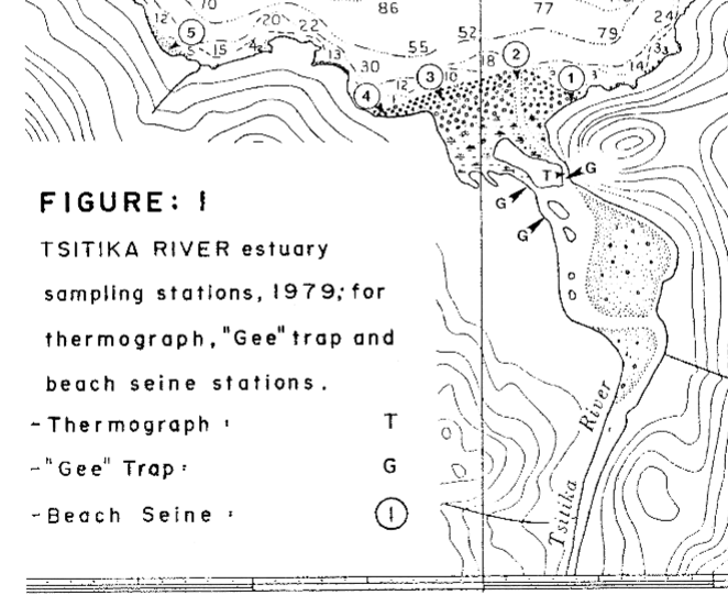
Preliminary Results of a Baseline Study of the Lower Tsitika River and Estuary, May, June and July, 1979
DFO investigation on Fisheries resources and ecosystem parameters of the Lower Tsitika River. See the 27 page PDF: preliminary_results_of_a_baseline_study

Fish changes in diets of nestling Rhinocerous Auklets and their implications
by Kees Vermeer and S.Jergen Westrheim PDF: nestling_auklet_diet_changes
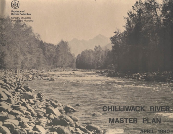
Chilliwack lake Management Plan, 1980
This is the early management plan for the ER. It has now been replaced with a more recent one ( 2002) A. INTRODUCTION The Chilliwack River flows westward from glacier- fed Chilliwack Lake to the flood plain of the lower Fraser River. Its broad valley, framed by the western Cascade Mountains, lies in the wet
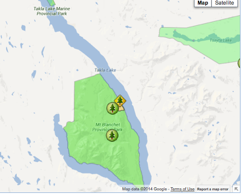
Takla Lake Ecological Reserve location map
The following map has been provided by BC Parks: