FER researchers protect BC’s biodiversity

Spring Beauty to White-Tailed Ptarmigan FER researchers protect BC’s biodiversity By Evelyn Hamilton, Chair, FER’s Science Advisory Committee This edition of the Log features research undertaken in the last few years by a handful of keen scientists and funded in part by Friends of Ecological Reserves. Donations from our supporters made this possible and we

Warden’s report -Visit to ER #76 – Fraser River Islands, March 31, 2007

Visit to ER #76 – Fraser River Islands, March 31, 2007 Sunny, but cold day, with temperatures down to 0 degrees overnight in Vancouver, up to about 9 degrees in day. Fresh snow on higher mountains (like Cheam), on top of existing high snowpack. Some wind. Water level low, around 1 metre at Mission. Departed

Provincial Marine Protected Areas in BC– 2007

Rich and Diverse Coastal and Marine Ecosystems British Columbia’s Pacific coast is one of the world’s most biologically diverse and productive temperate marine environments. Island archipelagos, deep fjords, shallow mudflats, estuaries, kelp and eel grass beds, strong tidal currents and massive upwellings all contribute to an abundant and diverse expression of marine biodiversity. The northeast

COSEWIC Assessment and Update Status Reportof Marmota vancouverensis in Canada

COSEWIC Executive Summary Vancouver Island Marmot Marmota vancouverensis The Vancouver Island marmot (Marmota vancouverensis) is a colonial ground squirrel related to the hoary marmot M. caligata and Olympic marmot M. Olympus. It is notable for its chocolate brown fur, unique vocalizations, atypical skull characteristics, and highly social nature. Distribution The Vancouver Island marmot is endemic

Environmental Monitoring at Race Rocks Ecological Reserve related to the Tidal Current Generator Installation at Race Rocks

Pam Thuringer of Archipelago Marine did these reports under contract from Lester Pearson College in the initial phases of the environmental impact assessment study for the Tidal Generator. Interim Report: http://www.racerocks.com/racerock/research/archipelago/archipelinterimreportJan200.pdf Final report: http://www.racerocks.com/racerock/research/archipelago/archipelfinalreport.pdf

Checleset Bay Research

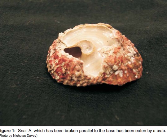
The red turban snail (Astraea gibberosa) as a model species to study how sea otter predation affects prey populations. September 28, 2006 Dear Friends, We spent our field season divided between Bamfield Marine Sciences Centre and the community of Kyuquot in Checleset Bay. In our ongoing research we have been using the red turban snail

Okanagan Region Invasive Plant Strategy 2006                  

 Prepared by Judy Millar and Crystal Klym–16 pages 2.0 invasive plant program background ESD, Okanogan region manages 330,791 ha of protected lands. Diverse ecosystems thrive within these lands and include sensitive grasslands, fertile riparian areas, fragile alpine meadows and productive forests these ecosystems, which provide critical habitat for many of British Columbia’s rare and

COSEWIC Assessment and Status Report : Misty Lake sticklebacks ,Gasterosteus sp.

SPECIES INFORMATION: The Misty Lake sticklebacks, a highly divergent parapatric lake-stream pair of threespine stickleback, are found in a single small lake on Vancouver Island, British Columbia (BC). Similar parapatric lake-stream pairs have also been well documented in two other systems in BC, Mayer and Drizzle lakes on Graham Island (Queen Charlotte Islands). These pairs

Baeria Rocks Ecological Reserve Warden Report 2006

Volunteer Warden, Anne Stewart, of the Bamfield Marine Sciences Centre,  Bamfield, BC, V0R1B0 Did this report for 2005-2006on the Bamfield Marine Sciences Centre Volunteer Biodiversity Monitoring Monitoring Activities Except for one visit made in collaboration with BC Parks personnel (described below as site visit May 31, 2006), biodiversity monitoring activities at the Baeria Rocks Ecological

2006 Invasive Plant Inventory In Parks and Protected Areas Of the Okanagan Region

The Okanagan Region governs more than 330,000 hectares of park, protected areas, ecological reserves and The Nature Trust of BC leaseback lands. The diversity of ecosystems that occur within these lands, support many of British Columbia’s identified species at risk. However, the introduction of various invasive plant species has severely threatened the integrity of these

Canoe Islands ER #17 Overview

See PDF  BC PARKS canoe islands COMPOSITION Physical:  The reserve 400m from the Valdes Island shoreline. These are composed of glacially smoothed sedimentary rocks of the Nanaimo Group, and lie at the eastern edge of Georgia Strait. Subtidally, strongly sloping bedrock substrates of irregular relief are interrupted by narrow sand-shell terraces. The channel between Canoe

IBA South Okanagan including Hayne’s Lease

FROM:http://www.ibacanada.com/site.jsp?siteID=BC261&lang=EN IBA Osoyoos Oxbows South Okanagan Valley, British Columbia Site Summary BC261 Latitude Longitude 49.096° N 119.539° W Elevation Size 280 – 500 m 14.27 km² Habitats: deciduous woods (temperate), native grassland, rivers/streams, freshwater marsh Land Use: Agriculture, Nature conservation and research, Hunting, Rangeland/pastureland, Tourism/recreation, Water management Potential or ongoing Threats: Arable farming, Dredging/canalization, Introduced