Introductory Floristic Analysis of Coastal Salt marsh Communities of the QCI
A report by Alex Inselberg August, 1979 Part 1 Windy Bay Part 2 Kootenay Inlet, Part 3 Port Chanal See the complete PDF: Salt Marsh Plant Communities


A report by Alex Inselberg August, 1979 Part 1 Windy Bay Part 2 Kootenay Inlet, Part 3 Port Chanal See the complete PDF: Salt Marsh Plant Communities
This is the complete application form . The report No. 290 includes legal description, geographical location, maps and purpose of the reserve. Also species list. Foster_et_al_ER Application_IBP_Form
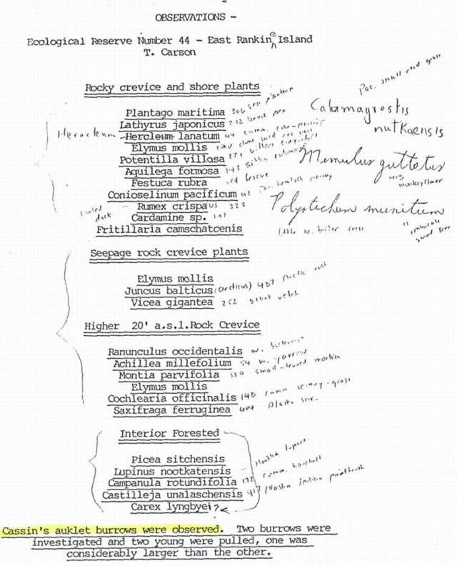
Trudy Carson ( now Trudy Chatwin) made field notes on rocky crevice and shore plants, seepage rock crevice Plants , higher level rock crevices( 20 ft) and interior forested areas. Cassin ‘s auklet burrows were observed. Two burrows were investigated and two young were pulled, one was considerably larger than the other.
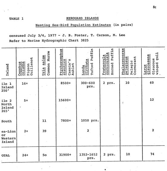
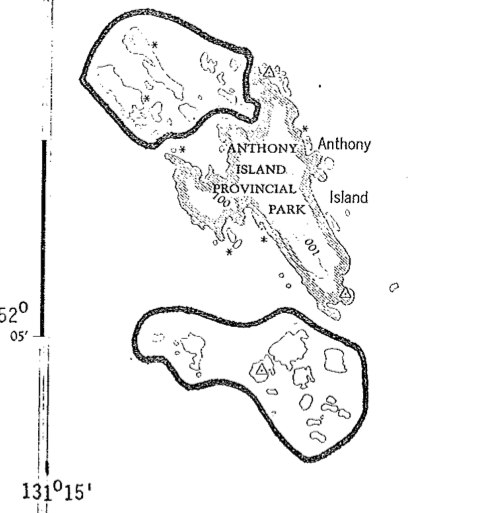
This proposal was submitted in 1978 by Trudy Carson prior to the creation of this reserve . The Kerouard Islands are located between Hecate Strait and the open Pacific Ocean, at the southern-most tip of the Queen Charlotte Islands. Isolated, rugged and extremely wild, these islands and their associated waters provide habitat for multitudes and

A.P. Nimmo and G.G.E.Scudder present an annotated checklist of the caddis flies of BC a total of 2148 species is reported from the province. Westwick lake is one of the areas of collection. nimmo_&_scudder_1978_ annotated_checklist_trichoptera_bc
Tom Reimchen and S.Douglas’s detailed observations . Owls timetable is given, See the PDF: interm_report_1978

Trudy Carson made these observations of Birds, plants and herbs and mosses on East Copper Island in May 1978.
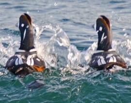
M.S. Rodway did this extensive report with maps of the Klashkish Valley area. See the complete PDF: bird_census_of_klaskish_valley Harlequin Ducks Image by Ryan Murphy
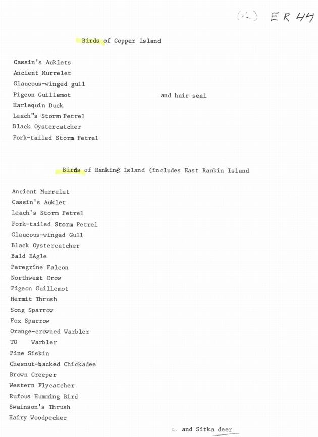
An anonymous survey of the Birds of these two Islands.
Bristol Foster and Trudy Chatwin provide a bird and mammal list. Also this PDF has a extensive list of Publications on Westwick lake. PDF: carson_&_foster_1978_wildlif_observations_westwick_er

Wayne Campbell of the Provincial Museum made these observations of seabirds in 1978

This seabird Census was done by Wayne Campbell in 1975/1976

PDF FILE: neudorf_et_al_1978_waterfowl_census_cecil_lake Ed.note: We were impressed with the volunteer efforts on this report. 5,400 hours of time were invested by fifteen volunteers, and a total waterfowl population of over 10,000 birds were documented. This last page, reproduced below provides a rather poignant synopsis, (maybe even reminiscent of Aldo Leopold’s thoughts. )
During the fall of 1977 the vegetation of alpha and Griffin Isalnds …was described and classified. the Braun-Blanquet releve method of phytoassociation was used in conjunction with the Ceska-Roemer computer program. —- Fall, 1977, Trudy Carson and Lynne Milnes: for Biology 418, Dr. Marcus Bell See the complete report in the PDF file:Vegetation(2)
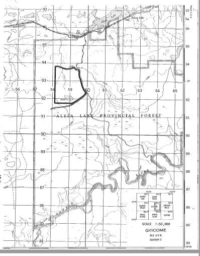
This reserve was proposed as an IBP area as the Aleza Lake Sub-boreal Forest by Victor Krajina , Jim Pojar, C. Steneker, D.Araki and C. Parsons . It includes a comprehensive species list and surveyors maps. It includes Part of the gently dissected, forested lowlands between the Fraser and Bowron rivers. See pdf file: purpose_map_airphoto_alzea_lake_er

by Cindy Lyon and Marg Watkins PDF : Vegetation and Animal Studies 1977
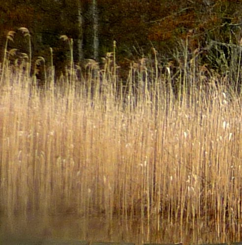
See this pdf file: plant_list(3) Seed Plants , Ferns, by Katherine Beamish Vascular plants of ER #28- Jim Pojar -1977 , May 1982,L. Milnes, S Riley, KI Beamish -1968 Liverworts and Lichens. Hand-drawn map. ………………………………………………. Phragmites communis… one of the grasses recorded in this species list in 1977 (G.Fletcher: photo)