News/Reports
Geology of the Itchta Ilgachuz range
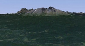
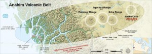
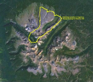
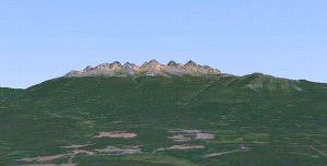
A quick survey of Wikipedia will show some interesting information about the Geology of this Volcanic Area . All images on this page have been adapted from NASA imagery.
The Anahim Volcanic Belt is a 600 km (373 mi) long volcanic belt, stretching from just north of Vancouver Island to near Quesnel, British Columbia, Canada. The Anahim Volcanic Belt has had three main magmatic episodes: 15–13 Ma, 9–6 Ma, and 3–1 Ma. The volcanoes generally become younger eastward at a rate of 2 cm (0.8 in) to 3.3 cm (1.3 in) a year. The Nazko Cone, which last erupted only 7,200 years ago, is the youngest Anahim volcano. These volcanoes are thought to have formed as a result of the North American Plate sliding westward over a long-lived center of upwelling magma called the Anahim hotspot. The hotspot is thought to be similar to the one feeding the Hawaiian Islands.
Future volcanism is most likely in the form of basaltic cinder cones, but eruptions of less mafic magma, typical of the eastern portions of the belt, cannot be ruled out. A series of earthquakes began October 9th, 2007 in the vicinity of Nazko Cone which was related to intense subterraenean volcanic activity in the area.
The volcanic belt is defined by 37 Quaternary basalt centers and three large shield volcanoes called the Rainbow Range, Ilgachuz Range and the Itcha Range. These three large volcanoes have built up dome-like piles of lava and fragmental rocks to a height of 8,130 feet (2,478 m) at Tsitsutl Peak in the Rainbow Range, 7,873 feet (2,400 m) at Far Mountain in the Ilgachuz Range, and 7,760 feet (2,365 m) at Mount Downton in the Itcha Range. The Rainbow Range is a low dome-like cone about 20 miles (32 km) diameter, with Anahim Peak an obsidian plug on its north-east flank. The Ilgachuz Range is 15 miles (24 km) or more in diameter, and the Itcha Range is 10 miles (16 km) wide and about 40 miles (64 km) long. All have been dissected by late Tertiary, pre-Pleistocene stream erosion.
Major volcanoes of the Anahim Volcanic Belt include:
- Ilgachuz Range, 2,410 metres (7,907 ft)
- Itcha Range, 2,368 metres (7,769 ft)
- Rainbow Range, 2,478 metres (8,130 ft)
Books available:
Anahim Volcanic Belt, Including: Rainbow Range (Chilcotin Plateau), Satah Mountain, Nazko Cone, Tsitsutl Peak, Itcha Range, Ilgachuz Range, Anahim Hotspot, Far Mountain, Anahim Peak, Mount Downton, Mount MacKenzie, 2007-2008 Nazko Earthquakes by Hephaestus Books
Pliocene Volcanism: Anahim Volcanic Belt, Pliocene Volcanoes, Niihau, Norfolk Island, Kauai, Fuerteventura, Tenerife, Mount Kenya Book Description by Books LLC
Anahim Volcanic Belt: Anahim Hotspot, 2007- 2008 Nazko Earthquakes, Ilgachuz Range, Nazko Cone, Rainbow Range, Itcha Range, Anahim Peak (Paperback) By Llc Books
The Anahim Volcanic Belt is a 600 km (373 mi) long volcanic belt, stretching from just north of Vancouver Island to near Quesnel, British Columbia, Canada. The Anahim Volcanic Belt has had three main magmatic episodes: 15–13 Ma, 9–6 Ma, and 3–1 Ma. The volcanoes generally become younger eastward at a rate of 2 cm (0.8 in) to 3.3 cm (1.3 in) a year. The Nazko Cone, which last erupted only 7,200 years ago, is the youngest Anahim volcano. These volcanoes are thought to have formed as a result of the North American Plate sliding westward over a long-lived center of upwelling magma called the Anahim hotspot. The hotspot is thought to be similar to the one feeding the Hawaiian Islands.
Future volcanism is most likely in the form of basaltic cinder cones, but eruptions of less mafic magma, typical of the eastern portions of the belt, cannot be ruled out. A series of earthquakes began October 9th, 2007 in the vicinity of Nazko Cone which was related to intense subterraenean volcanic activity in the area.
The volcanic belt is defined by 37 Quaternary basalt centers and three large shield volcanoes called the Rainbow Range, Ilgachuz Range and the Itcha Range. These three large volcanoes have built up dome-like piles of lava and fragmental rocks to a height of 8,130 feet (2,478 m) at Tsitsutl Peak in the Rainbow Range, 7,873 feet (2,400 m) at Far Mountain in the Ilgachuz Range, and 7,760 feet (2,365 m) at Mount Downton in the Itcha Range. The Rainbow Range is a low dome-like cone about 20 miles (32 km) diameter, with Anahim Peak an obsidian plug on its north-east flank. The Ilgachuz Range is 15 miles (24 km) or more in diameter, and the Itcha Range is 10 miles (16 km) wide and about 40 miles (64 km) long. All have been dissected by late Tertiary, pre-Pleistocene stream erosion.
Major volcanoes of the Anahim Volcanic Belt include:
- Ilgachuz Range, 2,410 metres (7,907 ft)
- Itcha Range, 2,368 metres (7,769 ft)
- Rainbow Range, 2,478 metres (8,130 ft)
-
Origins
The Ilgachuz Range began erupting about 5 million years ago and has grown steadily since then. Like all of the Anahim volcanoes, the Ilgachuz Range has its origins in the Anahim hotspot—a plume of magma rising from the Earth’s mantle in central British Columbia. The hotspot remains in a fixed position, while the North American Plate drifts over it at a rate of 2 to 3.3 centimetres per year. The upwelling of the hot magma creates volcanoes, and each individual volcano erupts for a few million years before the movement of the plate carries it away from the rising magma. However, where hotspots occur under continental crust, basaltic magma is trapped in the less dense continental crust, which is heated and melts to form rhyolites. These rhyolites can be quite hot and form violent eruptions, despite their low water content.
The hotspot has existed for at least 13 million years, and the Anahim Volcanic Belt stretches almost 600 kilometres (400 mi) away from the hotspot. More recently, the hotspot has formed the Itcha Range and Nazko Cone, a cinder cone east of the Ilgachuz Range and the youngest Anahim volcano. The Ilgachuz Range is the largest of these, although the Rainbow Range is the largest of all volcanoes in the Anahim Volcanic Belt.

Smooth northern flanks of the Ilgachuz Range are remnants of the original shield volcano.. From Nasa World wind


