
by: Gerry van der Wolf Warden
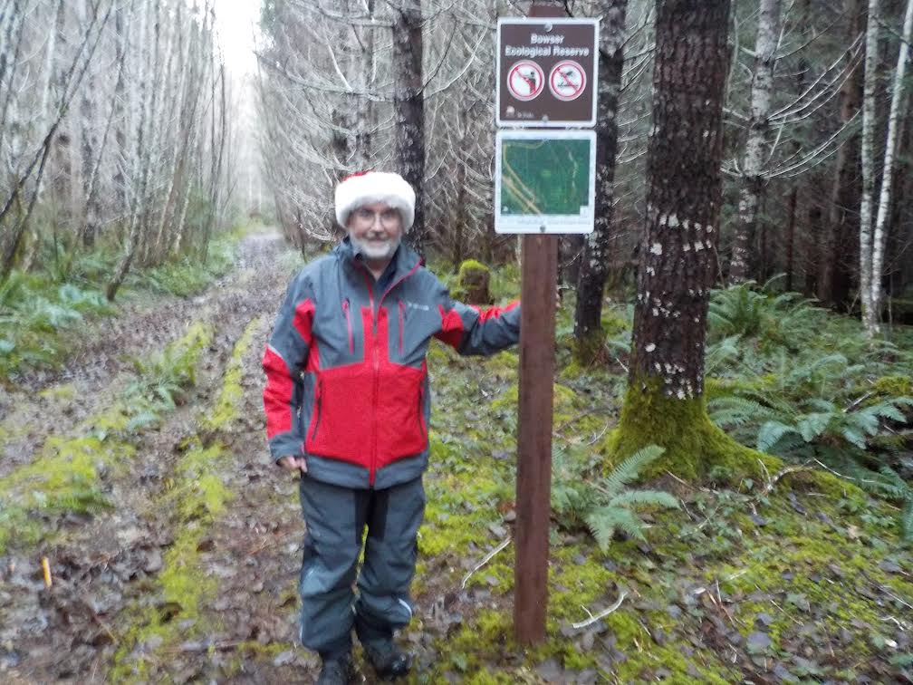
Bowser Ecological Reserve
2023 Annual Report – Bowser Ecological Reserve
Photos to be added later:
January 25, 2023
Gerry parked at the 90 km sign at 8:50 am and walked in to check on the monitoring equipment and will report to Jessica that all is well.
Hazel met Gerry at the gate at 9:00 and we drove to the fork at 1.5 km.
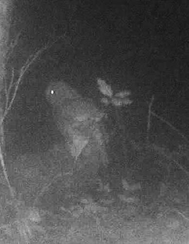
We hiked down the access road paralleling the south border of the reserve and located the spot approximately 400 meters from the fork, which represents the border of the reserve. We flagged the spot to facilitate erecting a sign in future. We continued to the spot where the two cameras were positioned. Both memory cards had images, one showed both internal and backup batteries were 100%; the other showed the backup batteries were dead and the internal battery at 50% so we took it to further analyze at home. The other camera we took to reposition.
We hiked back to the vehicle and then drove to the gravel pit road. We hiked down it to the fork where we placed the camera. Heading back, we immediately noted a red squirrel which scampered up a tree but made no sound.
We drove back to the gate, noting a red squirrel crossing the road in front of us.
We picked up a small amount of garbage along the hike which was completed under clear skies and 5 degrees temperature. We left the gate at 1:00 pm
===================================
February 24, 2023
Gerry parked at the 90 km sign at 10:15 am and walked in to check on the monitoring equipment and will report to Jessica that all is well.
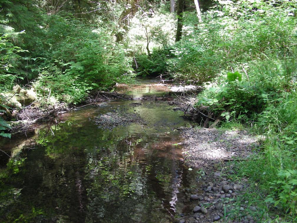
Gerry met Mattias Morrison, Senior Park Ranger, BC Parks at the gate at 10:30, where Mattias was in conversation with a dog walker who had returned to his vehicle. We drove to the fork at 1.5 km. We stopped where we could see a reserve boundary sign that had been rotated to face the opposite direction and righted it. It had also been defaced. Mattias noted on his device that the boundary of the reserve was much further into the forest. At the fork, we hiked along the right fork and determined that the spot Gerry had previously chosen for the reserve boundary was relatively accurate. We noted fresh deer tracks on the trail. We continued along to the end of the trail at the edge of Chef Creek. On the hike back we spotted a red squirrel crossing the trail directly ahead of us; there was no chatter.
We discussed potential projects and activities including replacing signage and garbage pickup and next steps in advocating for closing the gate.
The hike was completed under lightly overcast skies, -4 degrees temperature and light snow cover. We left the gate at 12:40.
.========================================
March 11, 2023
Gerry and Hazel parked at the 90 km sign at 9:00 am and walked in to check on the monitoring equipment and will report to Jessica that all is well.
We drove to the plantation road and encountered a man walking his two dogs. We talked to him and learned that he was the same fellow who had been speaking to Mattias when Gerry arrived the previous visit. We drove to the fork at 1.5 km. Heading back we parked at the gravel pit road and proceeded to the fork where the camera was positioned. We removed the card which had images of deer and an owl, and replaced it with a card with Spypoint’s updated firmware. We walked along the right fork to a point that had previously been marked as a waypoint to find tree planting debris. We collected some of the debris along the way but left the debris at the site for collection later in the year with Mattias’ summer students. We had noted fresh squirrel middens along the way and on the return trip had ventured into the forest to collect survey tape and encountered a red squirrel at that spot. The squirrel was in a tree near ground level but did not chatter. Photos were taken. We retraced our steps to the vehicle and drove to the .5 decommissioned road, parked and walked along it to a point where the Caltopo app determined the boundary of the reserve to be. That point coincided with the spot that a sign had originally been posted on a tree slightly off the trail. We positioned the second camera, with an SD card that had the updated firmware installed, in that area. We heard a woodpecker, likely a Pileated based on the sound, high in a tree. We pulled up a young Holy plant.
We then retraced our steps to the vehicle, collecting garbage. We then drove back and parked at the gate. We walked towards the boundary of the reserve and located it using the CalTopo app and flagged a tree at the corner of the reserve. We then retraced our steps and left the gate at 1:25 pm. The hike had been conducted under overcast skies with occasional sprinkles, increasing wind, and 5-degree temperatures.
================================================
March 11, 2023
Gerry and Hazel parked at the 90 km sign at 9:00 am and walked in to check on the monitoring equipment and will report to Jessica that all is well.
We drove to the plantation road and encountered a man walking his two dogs. We talked to him and learned that he was the same fellow who had been speaking to Mattias when Gerry arrived the previous visit. We drove to the fork at 1.5 km. Heading back we parked at the gravel pit road and proceeded to the fork where the camera was positioned. We removed the card which had images of deer and an owl, and replaced it with a card with Spypoint’s updated firmware. We walked along the right fork to a point that had previously been marked as a waypoint to find tree-planting debris. We collected some of the debris along the way but left the debris at the site for collection later in the year with Mattias’ summer students. We had noted fresh squirrel middens along the way and on the return trip had ventured into the forest to collect survey tape and encountered a red squirrel at that spot. The squirrel was in a tree near ground level but did not chatter. Photos were taken. We retraced our steps to the vehicle and drove to the .5 decommissioned road, parked and walked along it to a point where the Caltopo app determined the boundary of the reserve to be. That point coincided with the spot where a sign had originally been posted on a tree slightly off the trail. We positioned the second camera, with an SD card that had the updated firmware installed, in that area. We heard a woodpecker, likely a Pileated based on the sound, high in a tree. We pulled up a young Holly plant.
We then retraced our steps to the vehicle, collecting garbage. We then drove back and parked at the gate. We walked towards the boundary of the reserve and located it using the CalTopo app and flagged a tree at the corner of the reserve. We then retraced our steps and left the gate at 1:25 pm. The hike had been conducted under overcast skies with occasional sprinkles, increasing wind, and 5-degree temperatures.
spypoint
============================================
April 26, 2023
Gerry and Hazel parked at the 90 km sign at 8:50 am and walked in to check on the monitoring equipment and will report to Jessica that all is well.
We drove the plantation road to the fork at 1.5 km. then headed back to the gravel pit road. We walked along it, eradicating Scotch Broom along it and at the gravel pit. We continued along the fork to retrieve the camera positioned there, then continued along the left fork to the area where illegal logging had occurred many years ago.
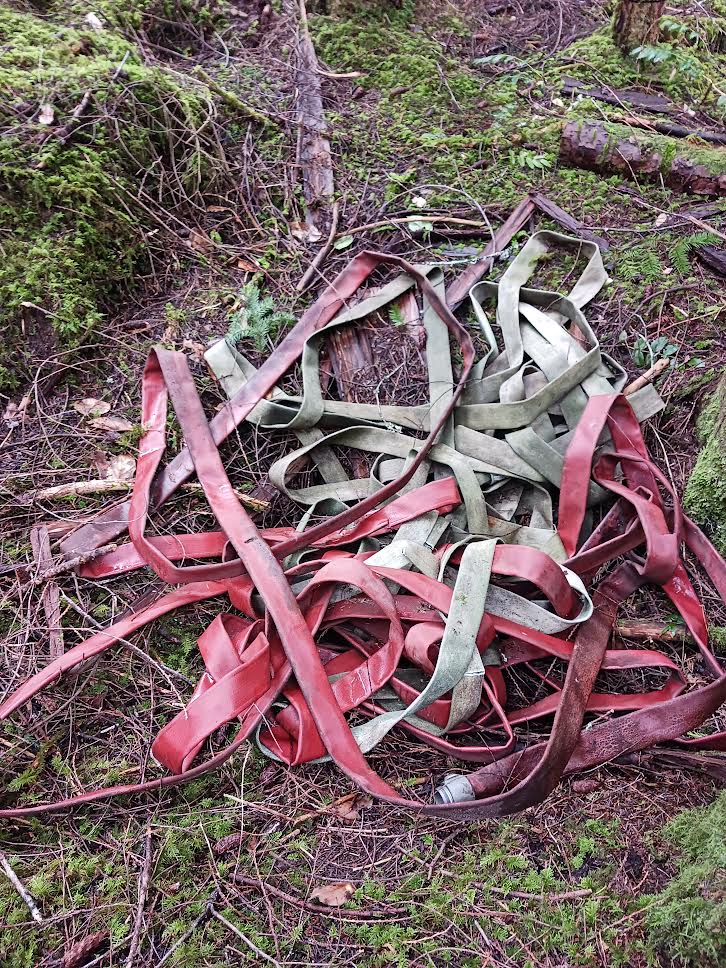
We returned to the vehicle and continued to the .5 decommissioned road and walked along it to the boundary of the reserve where the second camera was positioned and retrieved it. Both cameras will be brought home to inspect and to attempt to determine how to install replacement memory cards that will function. We returned to the vehicle and proceeded back to the gate passing two ladies walking. We noted a large quantity of fire hose dumped in a hollow beside the road, which will be reported to the RDN for removal.
We collected a small amount of garbage during the trip which was completed under partly sunny skies but a wet understory. We noted trilliums blooming a number of places and a large squirrel midden on the .5 decommissioned road. We left the gate at 11:45.
=============================================
May 25, 2023
Gerry and Hazel parked at the 90 km sign at 8:45 am and walked in to check on the monitoring equipment and will report to Jessica that all is well.
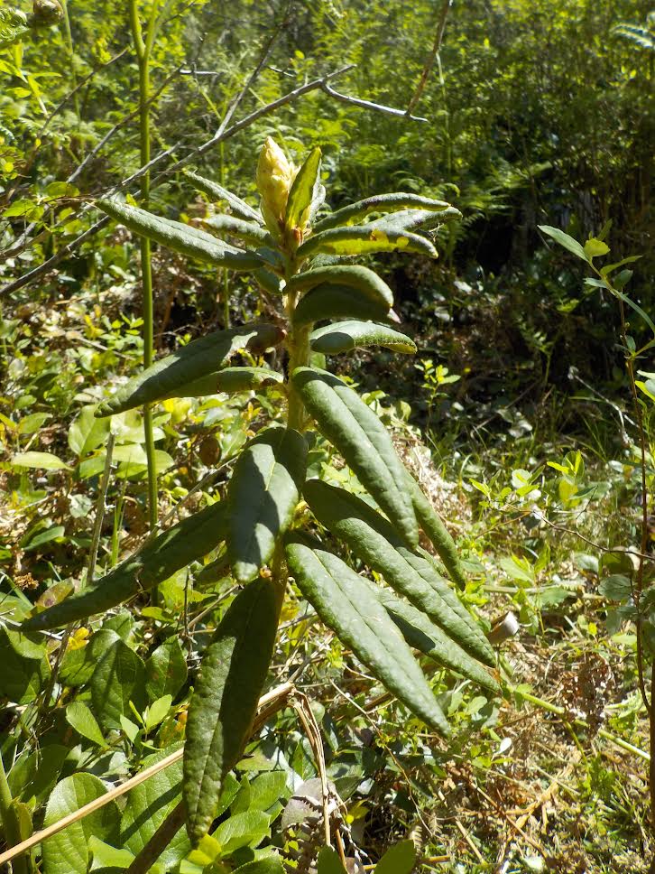
We drove up the plantation road to the fork at 1.5 km. the returned and parked at the gravel pit road and walked in to the fork, took the right and followed it to the next fork and took the left and followed it a distance then thought the other fork would provide better access to the former grow op site we were trying to reach. We retraced our steps then mounted the camera and struck off through the forest following the GPS compass direction. We located the grow op site and discovered additional plastic bins and pails we had not seen the year before as well as the plastic potting bags we were intending to retrieve. We assembled the waste in a pile to be collected at a future date. We then followed the GPS compass direction, salal surfing our way back to the gravel pit road. We noted a plant which resembled rhododendron and photographed it for identification. We encountered a quantity of tree planting waste and took it for disposal.
Driving back, we encountered some Scotch Broom along the road which we eliminated.
The hike was completed under sunny skies and 18 degrees temperature.
We left the gate at 12:30.
====================================
June 26, 2023
Gerry and Hazel parked at the gate at 9:00 am with plans to walk the perimeter of the reserve. We headed westerly and stopped at the eastern edge which we had previously marked with flagging tape. We noted a tree closer to the highway with tape and checked it out. It was marked NE, though there was no sign indicting the reserve boundary. We then continued westerly and checked out the monitoring equipment. We will report to Jessica by email that all is well. We proceeded to approximately the northwest corner and marked it as a waypoint. We then headed southerly along the western boundary to the point where it meets Chef Creek and way-pointed the spot. We continued to follow the boundary as it coincided with Chef Creek and stopped for lunch at a spot previously way pointed as a lunch spot. We continued along the creek to the spot previously way pointed as the southwest corner, then followed the road that parallels the southerly boundary. We then proceeded to the junction with the plantation road and followed it back to the gate. We removed a small amount of garbage.
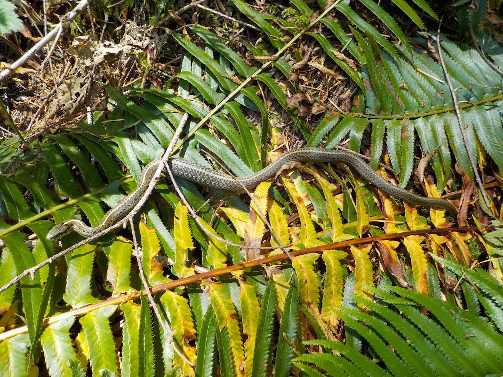
We removed one medium sized holy and way pointed the spot to check on in future. We saw numerous squirrel middens and three red squirrels; none made a sound as we approached. We heard one small woodpecker and one pileated on the walk. We photographed a snake, most likely a Western Terrestrial Garter.
We completed the walk under sunny skies, a light breeze, and warm temperatures. We left the gate at 3:30 pm.
 ========================================
July 10, 2023
Gerry and Hazel parked at the 90 km sign at 8:45 am and walked in to check on the monitoring equipment and will report to Jessica that all is well.
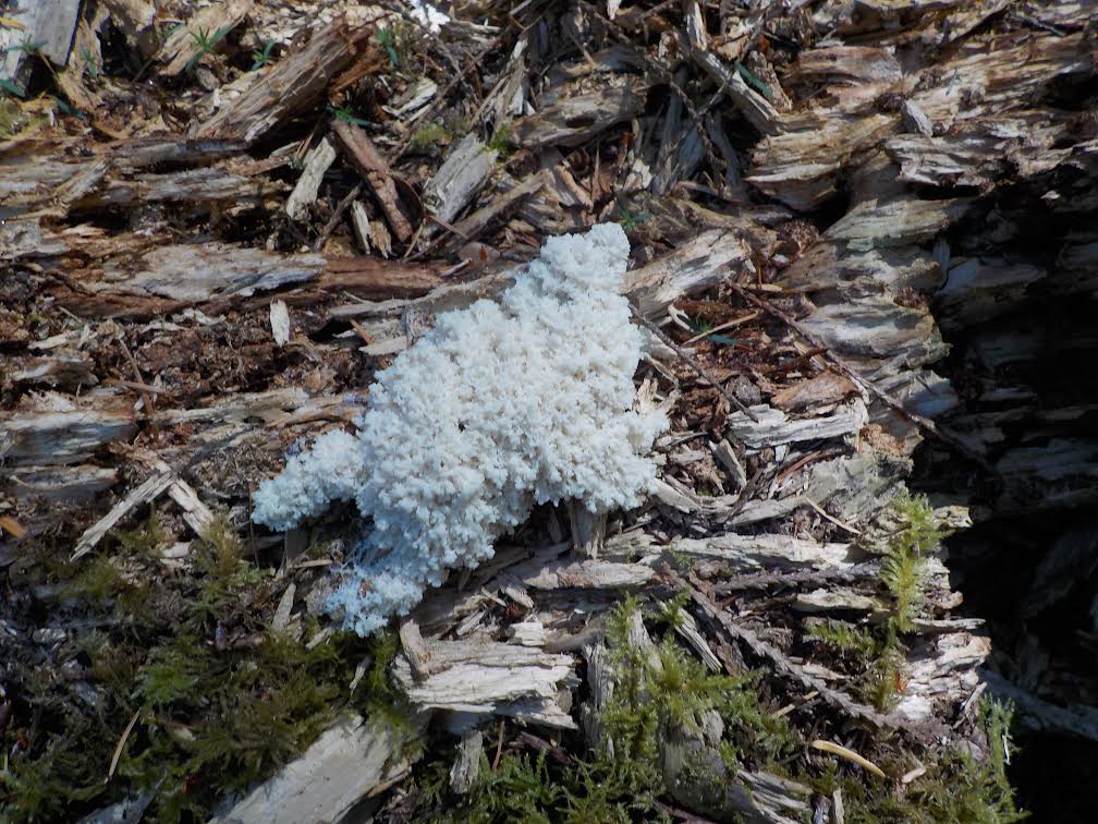
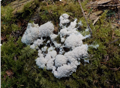
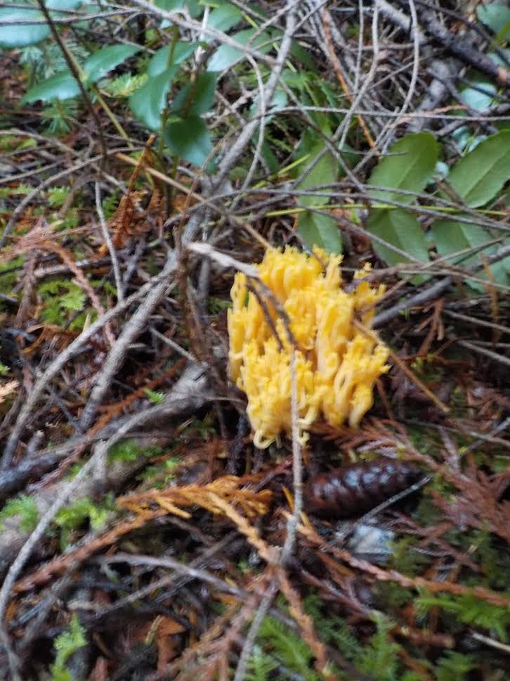
We drove to the fork stopping at the tipping spot and the logging site where there was no new activity. We saw two red squirrels chasing each other across the road. We parked at the .5 decommissioned access road and walked in to the boundary of the reserve then proceeded through the forest to the berry study site, photographing an unusual fungus along the way.
Both GPS units were behaving erratically, perhaps a result of sunspot activity.
We measured each branch and counted the berries, which will be reported separately. On the walk back we saw a red squirrel on a log directly in front of us. It scurried about but did not make a sound. We returned to the vehicle and proceeded back towards the gate. We picked up the box of garbage and bucket found the previous month.
We left the gate at 11:30. The walk was completed under sunny skies, a light breeze and 18 degrees temperature.
August 14, 2023
Gerry and Hazel parked at the 90 km sign at 8:50 am and Gerry walked in to check on the monitoring equipment and will report to Jessica that all is well.
We parked at the entrance and walked in to the .5 Decommissioned Road then followed it to the edge of the BER and headed through the forest towards the berry study patch where we collected the berries. The berry study will be submitted separately.
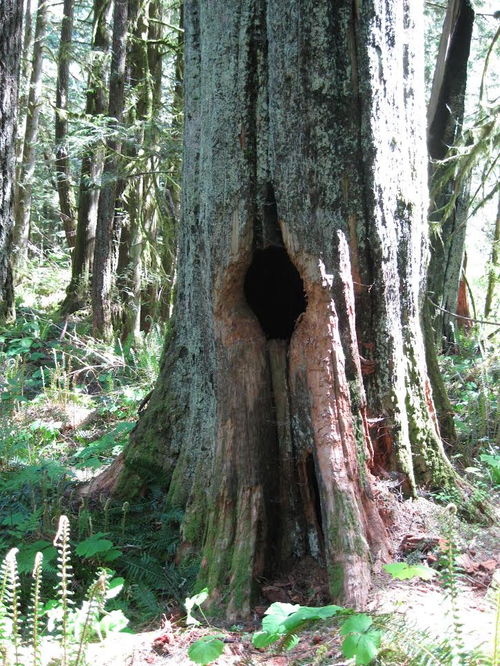
We headed across the gully and through the forest towards the hollow tree. We confirmed that the camera is still positioned there and does not appear to have been checked in some time, which will be reported to Erica separately. We noted many spots that were still wet with standing water and occasionally small rivulets of flowing water. The creeks we crossed over were also flowing. We waypointed a couple of large Douglas Fir that were not on our list and will return to measure them.
We then headed back through the forest, towards the northwest corner of the reserve, walking along its boundary. Within sight of the highway, we headed towards the gate. We noted several squirrel middens near small burrows in the ground.
We collected garbage and removed a Holly plant.
We left the BER at 1:40 having completed our hike under clear skies and 26 degrees temperature.
==========================================
September 7, 2023
Gerry parked at the 90 km sign at 12:45 pm and walked in to check on the monitoring equipment and will report to Jessica that all is well.
Mary Toews, FLNR and Monica Mather, WLRS joined Gerry and we proceeded up the road and parked at the entrance to the plantation road. We walked up the road to the .5 decommissioned road, then followed it to the boundary of the BER. We headed towards the berry patch, then to the gully crossing, then towards the hollow tree bear den. We noted a lobster mushroom emerging. We reached the hollow tree and Mary and Monica dismounted the camera, replaced the batteries and memory card, remounted the camera and surveyed the den, collected hairs and remarked on marks that appeared to be claw marks on the exterior of the tree. A length of barbed wire was stapled to the rim of the den entrance to capture hair samples. Pictures and various measurements were taken. Gerry was instructed on protocols for follow-up visits. Mary explained how to differentiate bracken fern from lady fern.
We proceeded to the squirrel transects and walked through each looking and listening for squirrels. None were noted and no middens were seen. A separate squirrel report will be filed after subsequent visits. We hiked back along the .5 decommissioned road then along the plantation road back to the entrance. We left at 3:30 pm. The weather was clear.
==============================================
October 10, 2023
Chris parked at the 90 km sign at 8:45 pm and Gerry walked in to check on the monitoring equipment and will report to Jessica that all is well.
Chris and Gerry and Hazel drove up the plantation road to the fork at 1.5 km, parked and walked along the road paralleling the southern boundary of the BER.
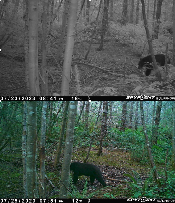
We walked back to the vehicle and drove to the gravel pit road and parked. We walked along the road to the gravel pit. We continued on to the fork, took the right fork and followed that road to the camera. It was removed to recharge the internal battery and replace the backup batteries. The memory card had multiple images of deer and black bear.
We walked back to the vehicle collecting a small amount of garbage and drove back to the gate.
The walk was completed under light rain with intermittent heavier showers. We left the gate at 11:00 am
=======================================================
October 23, 2023
Gerry parked at the 90 km sign and walked in to check on the monitoring equipment and will report to Jessica that all is well.
Gerry and Hazel met up at the gate and walked to the .5 decommissioned road then followed it to the point where the squirrel transects can be accessed. We followed the three transects to the end but did not see or hear any squirrels nor did we see any fresh middens. A separate squirrel count report will be filed. We found two well established holy plants and pulled them up and cut the larger stems and marked them on the GPS’s. We then headed towards the gully crossing point, past the berry study plot and back to the .5 decommissioned road. We noted many fungi growing though there were few oyster mushrooms where they had been plentiful in the past.
We met up with Mattias and Eric at the gate at 10:30 as arranged. Hazel left the BER and Gerry, Mattias and Eric drove up the plantation road to the gravel pit road, parked and followed the road to the first fork where a BER identification sign was installed. Gerry walked along the left fork to the area where illegal logging had occurred years ago and noticed a squirrel crossing the path.
We returned to the vehicle and drove further along the plantation road to the fork at 1.5 km, took the right fork and drove to the boundary of the BER. An identification sign was installed and the camera mounted in the vicinity.
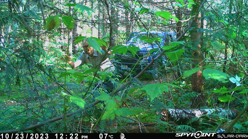
Mattias checking the camera alignment
We returned to the plantation road and followed it back to the gate. We left the gate at 12:15. The skies were clear, the sun shining.
==============================================
November 28, 2023
Chris and Gerry parked at the 90 km sign and Gerry walked in to check the monitoring equipment and will report that all is well.
We drove along the plantation road to the fork at 1.5 km, where we parked and walked the south perimeter road to check on the newly installed sign.
We walked back to the vehicle and drove back down the plantation road to the gravel pit road and parked. We walked to the second newly installed sign and then proceeded along the left fork to the illegal logging site. We photographed various fungi. We retraced our steps picking up a small amount of garbage including a handheld Sportdog device, then drove back to the gate.
We left the gate at 10:15 having completed the hike under overcast skies.
=====================================
December 22, 2023
Chris and Gerry parked at the 90 km sign at 8:00 am and Gerry walked in to check on the monitoring equipment and will report to Jessica that all is well.
We drove along the plantation road to the 1.5 fork, parked and walked in along the right fork to the newly erected sign. We recovered the camera and took it to be recharged.
We walked along the road to the creek edge indicating the boundary of the reserve. We retraced our path back to the vehicle and proceeded back to the gravel pit road and parked. We followed the gravel pit road to the first fork where the second new sign stands, and took the right fork and followed it until we reached a low and very wet spot. We located a large plastic drum that had become buried over time and extracted it as well as some plastic oil containers, and we collected a small amount of other garbage on the walk. We retraced our route back to the vehicle and then proceeded down the plantation road to the gate.
We left the gate at 10:30. The hike was completed under overcast skies, mild temperatures and wet underbrush.
=========================================
We want to thank Parks BC and the staff who support our activities and provide guidance throughout the year making this volunteer activity both enjoyable and meaningful.
Gerry van der Wolf
Hazel Foster
Chris James. Wardens, Bowser Ecological Reserve