
May 12, 2012 was the deadline for the submission of the First Written Requests from Intervenors –to the National Energy Board Hearings for the Kinder Morgan/Trans Mountain Pipeline Extension . The answers from Kinder Morgan will be provided by June 18
The next deadline for followup questions is in January
Link to the reponses from FER to the response of Kinder Morgan: July 4, 2014
Link to the Application for Intervenor Status for the Board of FER:
Link to all posts on the Ecoreserves website related to the Oil Spill Threat
Link to the PDF version of this file: FER__to_KM_onTMX_project_from_FERs_May_11_2014_-_A3W7H0
Link to Index for The Application for the Trans Mountain Expansion Project
Link to the complete list of Information Requests by all Intervenors:
The Board of Friends of Ecological Reserves, as an Intervenor submitted the following :

Information Request to Trans Mountain Extension Project TMX from Friends of Ecological Reserves (FER) May 1st 2014
Mr. D. Scott Stoness
Vice President, Finance & Regulatory Affairs
Kinder Morgan (KM) Canada Inc.
Suite 2700, 300 5th Avenue SW Calgary, AB T2P 5J2 Facsimile 403-514-6622
Email Regulatory@transmountain.com
Mr. Shawn H. T. Denstedt, Q.C.
Osler, Hoskin & Harcourt LLP
Suite 2500, 450 – 1st Street SW Calgary, AB T2P 5H1
Facsimile 403-260-7024 Email Regulatory@transmountain.com CC to NEB
Dear Mr. Stoness and Mr. Denstedt:
‘Friends of Ecological Reserves’ (FER) are a small Non-Government Environmental Organization based out of Victoria, which has provided a support role over the past 40 years, in the maintenance of Ecological Reserves in BC. Ecological Reserves are managed by BC Parks staff with whom we work as volunteers. We maintain a web site that clarifies our strategic goals and purpose. https://ecoreserves.bc.ca/
We are raising a number of concerns with the work you have completed as part of the Environmental Review over the TMX project for Kinder Morgan (KM).
We are limiting our concerns to marine ecosystems along the tanker route, potential impacts to Ecological Reserves based on what we have learned by reading the Marine Consultants reports you commissioned.
Our overall conclusion is that there is a lot of good and useful information in the reports provided, but the reports filed in the applications are wanting in some critical areas and further work is definitely needed. It is our sincere hope this information request, when addressed, can round out the information needed to complete a credible and understandable assessment of what environmental impacts can be realistically anticipated over the life of your project. It is hoped that this information, when provided will help the NEB panel decide on how to guide you and place permit conditions for approval over managing the marine portion of this project.
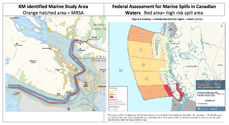
Concern 1: The size of the Marine Regional Study Areas boundary. Reference: Stantec Consulting report 1231-10494 REP-NEB-TERA-00027 December 2013
Preamble: The Marine Regional Study Area (MRSA) identified in the Stantec report and shown in Figure 1 was used to bound the information search and reporting on environmental values. This area is approximately half the size of the high-risk spill area identified in the federal government study called “A Review of Canada’s Ship-Source Oil Spill Preparedness and Response Regime”. (https://ecoreserves.bc.ca/wp-content/uploads/2014/02/transport_canada_tanker_report_accessible_eng.pdf).
There were no field studies undertaken by Kinder Morgan for the marine systems and the reports are based on existing information, office study and modelling. It is unclear why the study area was limited to half the area potentially affected by chronic oil from increased shipping and areas identified at high risk for marine spills. Concern 12 in this information request is specific to chronic oil. FER is concerned that the environmental assessment: (1) has been too limited in area, and; (2) excludes marine ecosystems potentially impacted over the life of the TMX project (which could be two to three decades) from exposure to increased oil spill risk in the area identified in the federal government report and shown in Figure 1.
Figure 1. Comparison of Marine Regional Study Areas (MRSA) and High Risk Spill Area
There are 33 Ecological Reserves (ERs) in BC with a marine component and potentially 17 will be impacted by increased tanker traffic and considered to be at high risk of potential spills (See Table 1 for a list of potentially impacted ERs). The Ecological Reserves Act defines the purpose of ERs to be: (Access the ER Act at http://www.bclaws.ca/EPLibraries/bclaws_new/document/ID/freeside/00_96103_01)
2
|
KM identified Marine Study Area Orange hatched area = MRSA |
Federal Assessment for Marine Spills in Canadian Waters Red area= high risk spill area |
- (a) areas suitable for scientific research and educational purposes associated with studies in productivity and other aspects of the natural environment;
- (b) areas that are representative examples of natural ecosystems in British Columbia;
- (c) areas that serve as examples of ecosystems that have been modified by human beings and offer anopportunity to study the recovery of the natural ecosystem from modification;
- (d) areas where rare or endangered native plants and animals in their natural habitat may be preserved;
- (e) areas that contain unique and rare examples of botanical, zoological or geological phenomena
All ERs in Table 1 below have a marine component (either shoreline or sub tidal or both) and their purpose is to either represent regional marine ecosystems and/or protect habitat of rare and endangered species/ecosystems. All ERs have some level of baseline ecological information collected since their establishment. Some ERs have over 40 years of baseline information. The level of information varies between ERs.
FER has watched the gradual withdrawal of provincial and federal support for research and baseline monitoring over the last 40 years. FER believes that there is a level of corporate responsibility linked to social license when proposing large projects with potentially high environmental risks. In our information requests, we are looking for a clear commitment for support for environmental monitoring.
Table 1. Marine Ecological Reserves in MRSA and those outside MRSA but in the high risk spill zone (Fig 1). Elements of this framework are shown in Table 4.
3
|
Ecological Reserve Name (with marine component) |
Upland |
Foreshore |
MRSA |
|
1. Baeria Rocks |
2 |
138 |
Outside |
|
2. Ballingall Islets |
0.5 |
0 |
|
|
3. Ambrose Lake |
228 |
0 |
Outside |
|
4. Brackman Island * |
5 |
25 |
|
|
5. Canoe Islets |
0.6 |
0 |
|
|
6. Cleland Island |
7.7 |
0 |
Outside |
|
7. Hudson Rocks |
2 |
48 |
|
|
8. Francis Point |
9 |
8 |
Outside |
|
9. Lasquiti |
201 |
0 |
Outside |
|
10. Megin River |
50 |
0 |
Outside |
|
11. Mount Maxwell |
418 |
0 |
|
|
12. Oak Bay Islets |
11 |
121 |
|
|
13. Race Rocks |
2 |
225 |
|
|
14. Rose Islets |
1 |
0 |
|
|
15. Satellite Channel |
0 |
340 |
|
|
16. Ten Mile Point |
1 |
14 |
|
|
17. Trial Islands |
23 |
0 |
*Was an ER with some baseline information pre-dating transfer to Gulf Island National Park Reserve.
The oil spill report [Reference B19-14_-_V8B_TR_8B7_01_OF_24_ERA_MAR_SPILL_-_A3S4K7] section 8.1 confirms oil spills will move beyond the Marine Regional Study area.
Predictions from the stochastic modelling (Figures F.1 to F.8) indicate that for a 16,500 m3 spill, areas with a high to very high probability of surface oiling (≥50%) extend beyond the RSA to the south under winter, spring and summer conditions, and to the west under the fall seasonal conditions. For an 8,250 m3 spill, areas with high to very high probability of oiling extend beyond the RSA to the south under the winter condition only.
Information Request 1. Can KM identify, described and make reference to all 17 marine ERs listed in Table 1 (currently only four ERs are referred and described in the report the report by Stantec [Reference B19-14__V8B_TR_8B7_01_OF_24_ERA_MAR_SPILL_-_A3S4K7]
Information Request 2. Can KM demonstrate that it knows the location of all 17 ERs by amending their project maps to include all potentially impacted ERs?
Concern 2. Number of environmental Indicators and lack of specificity with regard to habitat indicators.
Preamble: FER supports the indicator species selected by Stantec report 9. MARINE CONSULTANT V8B_TR_8B1_MAR_RESOURCE_-_A3S4J5 however we think others needed to be included. The KM selected indicators are shown in Table 2 below. Some indicators are linked to species at risk, i.e. Steller Sea Lion and Southern resident killer whale, and other indicators linked to species that are culturally and commercially significant such the Pacific salmon.
It is understood there needs to be a finite number of indicator species to monitor and periodically report on through time and there is potentially a long list of species/ecosystems to choose from. However, the choice of indicators is exceedingly important and FER believes major indicators are missing. The report identifies 11 environmental indicators. Marine Resources Report Summary states: The six indicators selected for the assessment of potential effects of Project-related marine vessel traffic on marine resources are intertidal habitat, Pacific herring, Pacific salmon, southern resident killer whale, humpback whale, and Steller sea lion. The Marine Bird Report adds another five indicators [V8B_TR_8B2_MAR_BIRDS_-_A3S4J6 ] summary states: “Marine birds are considered to be valid indicators of marine-ecosystem health. The 5 selected marine bird indicators, Cassin’s auklet, fork-tailed storm-petrel, pelagic cormorant, surf scoter and glaucous-winged gull, each represent a subset of the diversity of marine bird species in the Marine RSA because of their resident or seasonal occurrence, their similar habitat requirements to other marine bird groups, their abundance and/or conservation status, and their sensitivity to changes in the environment, especially during the breeding season.
The 11 environmental indicators KM has selected in these two reports are shown in Table 2.
Table 2. Eleven environmental indicators identified by for KM.
4
|
Marine ecosystem, fish and sea mammal indicators as environmental health indicators |
|
1. Intertidal habitat ( FER is concerns by the lack of specificity each of the 14 shore zone habitats) |
|
2. Pacific herring |
|
3. Salmon (FER is concerned with lack of specificity for the salmon species Pink, Chum, Sockeye, Coho, Chinook). |
|
4. Southern resident killer whale |
|
5. Humpback whale |
5
|
6. Steller sea lion |
|
Marine Birds as environmental health indicators by Stantec |
|
7. Fork-tailed storm-petrel Oceanodroma furcata |
|
8. Cassin’s Auklet Ptychoramphus aleuticus |
|
9. Surf scoter Melanitta perspicillata Blue |
|
10. Pelagic cormorant Phalacrocorax pelagicus pelagicus |
|
11. Glaucous winged gull Larus glaucescens |
FER believes that there are a number of critical environmental indicators missing from those recommended by KM consultants and there is lack of clarity over some of those chosen. For example the intertidal indicator as a single indicators is too broad a category and is meaningless until it is linked to the specific shore zone types such as those identified on the shore zone maps (MARINE CONSULTANT V8B_TR_8B1_MAR_RESOURCE_-_A3S4J5 Figures 4.2 a-d). There are 14 shore zone habitat types such as: 1) rock with gravel, 2) rock with sand, 3) mud flat, 4) rock cliff, 5) sand beach, 6) sand flat, 7) estuary, 8) lagoon, etc. FER believes that each foreshore type is an indicator and that each is needed to define ecosystem condition prior to project commencement. A complete set of habitat shore zone indicators is a fundamental requirement for establishing baseline conditions prior to possible project approval as it will be a KM commitment to periodic monitoring or support for partners to monitor these sites over the life of the project.
Information Request 3. Will KM identify the 14 shore zone habitats as indicators and revise its indicator assessments to include descriptions of specific habitat classes such as mud flat, estuary, sand beach etc.? If KM does not agree with more specificity for habitat indicators, can KM provide the rationale for use of a single shore zone as being sufficient for impact assessment?
Information Request 4. Will KM identify each of the five salmon species Pink, Chum, Sockeye, Coho, and Chinook as an indicator rather than the single generic indicator “salmon” now identified? Can KM provide a scientific rationale as to why grouping of all into a generic salmon species indicator is suitable?
Concern 3. Absence of known marine bird colonies as indicators for long term monitoring and reporting of marine health.
Preamble: Marine Bird Report (Reference 1231-10494 REP-NEB-TERA-00028 December 2013) indicates that there more species of marine bird breeding in the RSA than the 5 indicators selected.
The Stantec Marine Bird report summary states: The 5 selected marine bird indicators, Cassin’s auklet, fork-tailed storm-petrel, pelagic cormorant, surf scoter and glaucous-winged gull, each represent a subset of the diversity of marine bird species in the Marine RSA because they are resident or seasonal.
Since the consultants reports indicate that the locations of colonies is known and shown in their reports, why are most known colonies omitted as indicators against which to measure impact and recovery?
The consultants list the breeding bird colonies in the MRSA and these are shown in Table 3.
Table 3. Marine Bird Breeding colonies within the MRSA.
In the case of sea bird colony species, each species represents itself as an appropriate ecosystem health indicator. It is mentioned in the summary statement of this Marine Bird report that there are 223 different waterbird species in the MRSA. Monitoring and helping maintain baseline information on 11 sea bird species with known colonies in the MRSA is not considered onerous. All colonies are at higher risk and need monitoring over the life to project. Shore birds are highly susceptible to shore zone pollution and recovery of breeding colonies may be indicated by trends in these colonies
Information Request 5. FER requests KM supply information to support exclusion of marine bird colonies listed in Table 3 and why shorebirds are not suitable for long term monitoring? Will KM include all sea bird colonies in the High Risk Oil zone shown in Figure 3 as indicator species for long term monitoring and impact assessment?
Concern 4: Absence of a representative of the shorebirds guild and a specific species against which to assess shore zone health.
Preamble: The intertidal guild of shorebirds has no indicator species identified. FER was encouraged that the NEB letter also noted this as a concern/deficiency in indicators. FER sees a need to expand the current list of marine birds to include representatives from the shorebird guild. The Great Blue Heron is also in the intertidal guild though it has some elasticity with regard to use of fresh water habitats, which the Black Oyster catcher lacks. Black Oyster catchers (BOC) are wide spread along the route and their breeding areas as shown Figure 2.
6
|
1. Pigeon Guillemot Colonies |
|
2. Pelagic Cormorant Colonies |
|
3. Glaucous-winged Gull Colonies |
|
4. Black Oystercatcher Breeding Areas |
|
5. Double -crested Cormorant Colonies |
|
6. Cassin’s Auklet Colonies |
|
7. Brandt’s Cormorant Colonies |
|
8. Rhinoceros Auklet Colonies |
|
9. Tufted Puff in Colonies |
|
10. Fork-tailed and Leach ‘s |
|
11. Storm -petrels Colonies |
Figure 2. Black Oyster catcher breeding sites are shown in green.
In addition to the Black Oyster Catcher colonies along the route, there are surveys in ERs along the tanker route that show four ERs have breeding Black Oyster catchers. https://ecoreserves.bc.ca/2013/12/17/black-oystercatchers-on-front-lines-for-oil-spills/ .
Information Request 6. Will KM supply information that supports exclusion of shorebirds as a guild and why shorebirds such as Black Oyster Catchers are not suitable for inclusion as an indicator? Will KM include Black Oyster Catchers as an indicator species for monitoring and reporting?
Concern 5. Absence of resident fish and forage fish species as indicators of marine health
Preamble: FER is pleased with the fish species chosen as indicators of marine health. However salmon and herring species are considered to be migratory, passing through the MRSA on annual migration patterns and not permanent residents. FER believes that there is a need to include a member of resident species guild to represent the health of marine ecosystems and suggest that rockfish species are appropriate resident species in need of baseline monitoring. Rockfish species (family Sebastidae) are already species of concern and Figure 3 shows on example of rockfish conservations areas near Victoria. FER is concerned that an oil spill may further risk recovering this species.
7
Figure 3. An example of rockfish conservation Areas (RCAs) near Victoria BC. Some RCAs are associated with Ecological Reserves.
Information Request 7. Will KM supply information to support exclusion of a resident fish species such as rockfish from the list of indicators? If there are no compelling reasons to omit rockfish, will KM include rockfish as an indicator of resident fish species?
Concern 6. Representing information that minimizes spill impacts in high risk zone by comparison of selected indicators to post spill to global species condition outside of the impact area.
Preamble: Environmental Impact assessments are designed to help NEB and the public clearly understand the risks to resources from this project. Deficiency in the number of indicators has been noted earlier. Given that a robust set of indicators is determined, then each indicator requires a numeric baseline be established within the potentially high risk impacted oil spill area (see Figure 1). Then for the public to understand oil spill impacts, there is a need to estimate potential mortality and recovery linked to oil spill scenarios worst case and smaller spills case against this baseline.
Using the marine birds report as an example FER finds the characterization of indicator baselines absent for high risk impact zone. For example the Marine Bird report [V8B_TR_8B2_MAR_BIRDS_-_A3S4J6] Table 4.4: provides bird counts for 237 bird species from inventories between 1962 and 2012. This information is related to inventory effort and data shows individual bird counts over a 40-year period but not the current population estimate or the range of variability (lowest to highest population fluctuations) within that period, nor the current population or trend. This report concludes that no supplemental studies will be needed. FER cannot support that there is no need for further study in light of the absence of baselines and trends and periodic reassessment over the life of the project. It is not possible to do an impact assessment without establishing an individual baseline against which to compare impact and measure recovery without some numerically disclosure.
8
The Oil Spill Report B19-14_-_V8B_TR_8B7_01_OF_24_ERA_MAR_SPILL_-_A3S4K7 concludes that “It is reasonable to expect marine bird recovery at a population level within two to five years following a large oil spill.” For the residents along the route it is of interest how well local populations recover specifically. Putting a local oil spill in the context of impacts to global populations of an indicator species, does not report on the condition for the residents along the route.
Oil Report [Reference B19-14_-_V8B_TR_8B7_01_OF_24_ERA_MAR_SPILL_-_A3S4K7] section 9 summarizes recovery rates of ecological resources following the 1989 Exxon Valdez spill. The spills report in Table 9.1, shows some of the environmental indicators and that, after 25 years, there is no recovery of herring, Pigeon Guillemot and Black Oyster catchers, Barrow’s Goldeneye, Harlequin Duck, shore communities and clams and mussels are still classed as recovering. Putting the impacts in context of the local populations in the risk area is a more reasonable measure of impacts than at the broader population level, which, for some species, is the North Pacific Ocean.
Information Request 8. Will KM provide population estimates by season for the 5 marine bird indicators identified by KM (Table 2) and the 11 bird species with colonies shown in Table 3? Will KM provide a population baseline and historic range of variability for each of the 16 bird species indicators in Table 2 and 3 as shown in Table 4?
Table 4. Minimum baseline information needed of environmental assessment marine bird indicator.
9
|
Marine Bird Indicator |
Historic population range within impacted marine area |
Recovery Impact Baseline |
Current population 2014 |
|
|
Lowest Historic population estimate/season |
Highest historic population estimate/season |
Needed for recovery within marine impacted zone requires periodic updating during the life of the project |
Trend increasing Trend Decreasing Trend Uncertain (future survey effort) |
|
|
5 identified by KM |
||||
|
11 breeding bird colony species (This IR Table 3 above.) |
||||
Information Request 9. We request KM provide population estimate information for the rockfish species within the Rockfish Conservation Areas within the MRSA to establish baseline information consistent with population variability as shown in Table 5.
Table 5. Minimum baseline information needed of environmental assessment rockfish indicator.
10
|
Rockfish Indicator |
Historic population range within impacted marine area |
Recovery Impact Baseline |
Current population 2014 |
|
|
Baselines needed for Rock Fish Conservation areas such as those shown in Figure 3 |
Lowest Historic population estimate |
Highest historic population Estimate |
Needed for recovery within marine impacted Requires periodic updating during the life of the project. |
Trend increasing Trend Decreasing Trend Uncertain (future survey effort) |
|
Rock fish species Inventory with towed camera or remotely control camera |
||||
Concern 7. Absence of importance of forage fish and identification of suitable micro habitats;
Preamble: Forage fish are the basis for much of the fish and sea mammal productivity in the Salish Sea and Strait of Juan de Fuca. The continued health and maintenance of their habitat is critical as these species are the base of the food chain. Of particular concern on the beaches of the ERs are two species, Pacific Sand Lance (Ammodytes hexapterus)and surf smelt (Hypomesus pretiosus). http://www.dfo- mpo.gc.ca/CSAS/CSAS/status/2002/SSR2002_B6-09_e.pdf. Their population levels and habitat condition together determine the condition of salmon, rock fish, many marine bird species and other marine mammal species. To learn more about forage fish and their role visit. http://www.lenfestocean.org/foragefish. This importance has been recognized by some local ENGOs such as the Mayne Island Conservancy Eel grass mapping project. http://www.conservancyonmayne.com/eg.php. For further understanding of the importance of the role of Pacific Sand Lance, access a study by Truscott and Thuringer 2003 in Baynes Sound. http://www.for.gov.bc.ca/tasb/SLRP/marine/south_island/baynes/docs/sandlance/Baynes_sandlance_ %20draftreport.pdf . FER is concerned with the recovery of forage fish and what has been learned since the Exxon Valdez’s spill. The shore zone mapping may be at too coarse a scale to identify many of the smaller suitable habitats.
Information Request 10. We request that KM show on maps where forage fish, Pacific Sand Lance and Surf smelt spawning habitat is located within the MRSA. Will KM show how much of forage fish habitat could be impacted by a worst case and smaller spill impact?
Concern 8. Marine mammal breeding colonies.
Preamble: Marine mammal breeding colonies exist in considerable numbers but are not mentioned. Reference by the consultant is to numerous sea mammal haul-outs only. Within a short distance of proposed tanker routes are several breeding and pupping colonies of harbour seals. They haul-out on shallow intertidal areas from the Oak Bay Islands to Race Rocks. The only pupping colony for the Northern Elephant seal in Canada started in 2009 at Race Rocks Ecological Reserve, after extirpation early in the 20th century. The significance of allowing this species, with such a limited range, to re-
establish and the responsibility to protect this species is considerable. FER believes that these colonies need to be included as indicators as top predators are a good indicator of marine health.
Information Request 11. We request a map showing the marine mammal breeding areas and haul-outs and seasonal census for these sites within the high spill as shown in Figure 1, including the Elephant seal and harbour seal birthing colony at Race Rocks Ecological Reserve.
Table 6. Baseline needs of marine mammals in the high risk oil spill impacted area.
11
|
Marine mammals |
Historic population range within impacted marine area |
Recovery Impact Baseline |
Current population 2014 |
|
|
Baselines needed for such as those shown in Figure 2 |
Lowest Historic population estimate |
Highest historic population Estimate |
Needed for recovery within marine impacted Requires periodic updating during the life of the project. |
Trend increasing Trend Decreasing Trend Uncertain (future survey effort) |
|
Southern resident killer whale |
||||
|
Humpback whale |
||||
|
Steller sea lion |
||||
|
Elephant seal |
||||
|
Harbour seal |
||||
Information Request 12. We request baseline information on each of the marine mammals shown in Table 6 and including baseline indicators shown in Table 7.
Table 7. Baseline information needed for environmental assessment of rockfish.
|
Marine mammal Indicator |
Historic population range within impacted marine area |
Recovery Impact Baseline |
Current population 2014 |
|
|
Baselines needed for each marine mammal. |
Lowest Historic population estimate |
Highest historic population Estimate |
Needed for recovery within marine impacted Requires periodic updating during the life of the project. |
Trend increasing Trend Decreasing Trend Uncertain (future survey effort) |
Concern 9. Recovery and removal of species impacted by an oil spill and human safety.
FER is aware that recovery of oily birds is extremely low and bird experts recommend that recovery of birds post oil spill is not warranted. There has been a publically-held belief that marine birds that are oiled can be successfully cleaned and will recover. A report on the Gulf oil spill concluded that well- meant public efforts to save a specific individual wildlife animal actually prolonged suffering of that individual as death was not avoided. The study concludes “According to serious studies, the middle-term survival rate of oil-soaked birds is less than 1 percent,” Gaus says. “We, therefore, oppose cleaning birds.” http://www.spiegel.de/international/world/gulf-of-mexico-spill-expert-recommends-killing-oil- soaked-birds-a-693359.html.
Information Request 13. That KM provide additional information on the percentage middle term survival and recovery of oily marine mammals and birds to help guide Environmental Non-Government Organizations and the public on wildlife rescue efforts linked to oiled sea life.
Information Request 14. What does KM plan for euthanizing and disposal of oiled marine animals?
Removal of contaminated birds from Ecological Reserves may be needed. We are concerned that if they remain in the marine ecosystem they will continue to pass their toxicity through the food web. These contaminated animals will need to be removed and we are unsure of training and resources for this. We are concerned with public safety around possible contact with toxically contaminated wildlife.
Information Request 15. What are the plans for public education to avoid hazard to human health?
We are concerned that information regarding chemical make-up of products transported at sea is not known to the public and that there will be insufficient time and resources on hand to address a worst case spill toxic spill.
Information Request 17. What plans do you have to provide this information to emergency responders and the public?
Information Request 18. What personnel and resources will be made available to remove these contaminated animals from Ecological Reserves?
Concern 10. Numeric baselines for all indicators and specific numeric mortality estimates link to Worst Case spill and smaller spill scenarios for species indicators.
The Oil Spill report B19-14_-_V8B_TR_8B7_01_OF_24_ERA_MAR_SPILL_-_A3S4K7 also notes that the absence of baseline information in advance of the Exxon Valdez’s oil spill made the recovery estimate difficult. We concur and believe it is the role of the NEB and KM to put these in place and link probable mortality (impact) to selector indicators and define recovery and provide an estimate of recovery within the impact areas. We do not believe baseline work and mortality estimates are frivolous as they are needed to prepare properly for an oil spill. Much detailed planning and forecasting is needed pre project approval.
Information request 19. Probable mortality rates for indicator species linked to the oil spill simulations and measured against all baselines. Probable recovery rates for each indicator.
12
Table 7. Example of impact assessment information needed to inform impact severity, duration and recovery for all indicators.
13
|
Indicator species |
Based line Population estimate |
Expected mortality For each seasonal simulation. |
Expected years for recovery period within impact area |
Estimated time to recovery to 75% level of baseline condition |
|
|
Information on additional species and habitats. Anticipate a need for a 3 fold increase in indicator species and clearer definition of impact zone. |
(See preceding Information requests for baselines for all indicators.) |
Worst Case Spill |
Smaller spill |
Declaration of recovery date |
|
Concern 11. Involvement of ENGOs with continued monitoring and citizen oversight during the life of the project.
The residents living along the tanker route have increasingly been providing greater amounts of baseline data on natural ecosystems through NGOs like FER. ER wardens provide extra eyes and ears for BC Parks. The best established monitoring/research in the marine 17 ERs along the tanker route is found at Race Rocks ER https://ecoreserves.bc.ca/portfolio_item/race-rocks-97/ which is supported partly by Pearson College which uses the ER as a student lab and which supports an award winning Race Rocks web page (http://www.racerocks.ca/wp/home/ ). Baeria Rocks ER (https://ecoreserves.bc.ca/portfolio_item/024-baeria-rocks/) is linked to the Bamfield Marine Field Station (http://www.bms.bc.ca/), another research oriented NGO.
More NGOs are taking on responsibilities for environmental monitoring and research. FER knows that governments will retain authority in legislation over natural resources but both provincial and federal agencies have steadily decreased funding over the decades for monitoring. This trend is not expected to change over the next few decades so that NGOs who have the interest and developed expertise, will to the extent possible, continue to provide a monitoring role and ideally this role could be formally expanded. Large projects like KM must include support for long term monitoring in their business plans and look to cooperative science-based NGOs as practical, cost effective approaches as part of their monitoring obligations. The consultants for KM did not identify an ongoing role for KM in long term monitoring. There is a role for KM, and a monitoring framework is needed to define that role andnidentify partners. Leaving this role solely to federal and provincial agencies and non-government agencies is not acceptable.
Information Request 20. Do you value the contributions of NGO monitoring such as FER Ecological Reserve wardens and their contribution to monitoring over the life of your project?
Information Request 21. Do you plan to maintain formal liaisons with Environment Non-government Organizations over the life of the project?
Information Request 22. Do you plan to support financially the on-going costs of marine ecological monitoring in ERs and other contiguous sensitive areas?
Information Request 23. Can you provide an estimate for thorough ecological monitoring of ERs through a recovery period?
Information Request 24. Do you plan to support a forum to periodically receive public input and address public concerns and adapt your practices during the life of this project?
Information Request 25 Will you financially support a public advisory committee, on-going costs of marine ecological monitoring in ERs and other contiguous sensitive areas?
Concern 12. Chronic oil spill hazards to ERs.
It has been recognized that the threat to marine ecosystems from chronic oil spills has had a large cumulative impact. For a better understand of chronic oil access www.earthpace.com/index.php/about/our-projects/37-chronic-oil-pollution.
Information Request 26. What is the estimate of the chronic oil pollution associated with current shipping? What increase in chronic oil pollution will be added by tanker traffic from the KM project? What are your plans to mitigate your chronic oil impacts?
Thank you for understanding our concerns with regard to monitoring in ERs and elsewhere. We look forward to your response to our information requests.
Board of the Friends of Ecological Reserves.
Mike Fenger President of Friends of Ecological Reserves mfenger(use the at sign)Telus.net
Garry Fletcher Board Member
Marilyn Lambert Board Member
Mary Rannie Board Member
Dr. Rick Page Board Member
Dr. Jenny Feick Board Member
Stephen Ruttan Board Member
Liz Williams Board Member
15