
Jim Pojar in February of 1981, as a member of the British Columbia Forest Service wrote this paper .
“a small intact west coast drainage system, biologically representative but with several floristic rarities; vegetation modified by extreme exposure; an estuary and a sand beach ecosystem; and the possibility (which needs further investigation) that the Brooks Peninsula may have to some extent escaped continental glaciation.”
The area is now a BC Provincial park , but it had all the earmarks of a potential ecological reserve. This paper describes the unique assemblage of vegetation and geology of the area.
Currently the closest Ecological reserves are Solander Island ER #14 just to the west off shore and Checlesset Bay ER #109 to the south.
See the complete pdf file here: NUNATAKS and NOOTKA_jimp
NUNATAKS and NOOTKA:
THE BROOKS PENINSULA, VANCOUVER ISLAND’S ICE AGE REFUGIUM
Jim Pojar
British Columbia Forest Service
Smithers, B.C. V0J 2N0
February, 1981 2
Introduction
The Brooks Peninsula lies 350 km northwest of Vancouver, but the distance might as well be three times as great. There are few wilder, more remote stretches of coastline in all of British Columbia. The peninsula thrusts at right angles from the west coast of northern Vancouver Island, forming a rugged mountainous abutment to the edge of the continental shelf (Fig. 1). No roads even approach the area; boat and helicopter provide the only reasonable access.
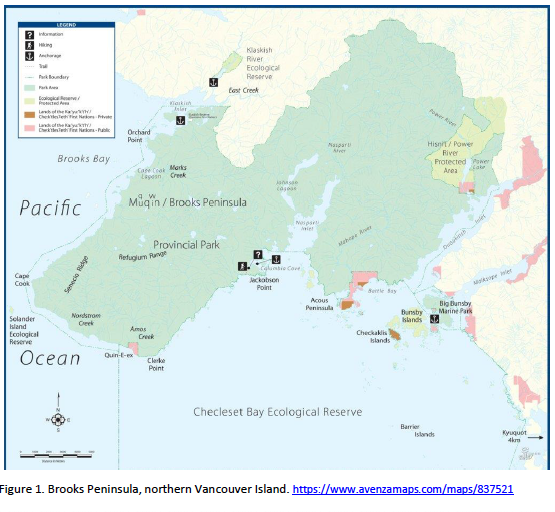 Figure 1. Brooks Peninsula, northern Vancouver Island. https://www.avenzamaps.com/maps/837521
First Feelers
Inaccessible as it is, it is not surprising that few contemporary people have visited the Brooks Peninsula. Even so, I had supposed the mere location and configuration of the area would have been sufficiently intriguing to attract exploration by early naturalists. However, it seems that the first botanists to visit the peninsula were a party from the University of British Columbia, in August 1975. The group included Judy and Geoff Godfrey, Richard Hebda, and John Pinder-Moss. W.B. Schofield inspired and sponsored the expedition, although he was unable to join it.

Figure 3. Tidal lagoon, evening light, June 1977.
Figure 2. Sand beach, tidal lagoon, and the nunatak, Brooks Peninsula
Brooks Peninsula.
The UBC botanists travelled by boat from Coal Harbour, and established their base camp behind a superb sand beach (Fig. 2) south of Orchard Point, on the northwest side of the peninsula. This beach fronts a picturesque tidal lagoon (Fig. 3) and estuary at the mouth of an unnamed stream. The stream drains boggy lowlands and part of the main mountainous backbone of the peninsula. This watershed includes the largest of several cirque lakes clustered in the rocky high country.
The UBC team spent six days collecting vascular plants, mosses, and liverworts. Beset by poor weather, they worked over primarily the lower elevations of the area. Foot travel through the dense coastal forest and spongy muskeg of the lowlands was difficult. A stiff wet bushwhack of several hours was required from the beach to the base of the mountains, where the work really began. The mountains were almost always shrouded in cloud, making route-finding challenging and risky.
Although the lowland collecting was rewarding, especially for the bryologists, the Vancouver botanists managed to push on to a high gravelly ridge on the one fine day they experienced. On gaining the ridge, they were rewarded with the finds of Gentiana platypetala, a large handsome species with stout, mostly solitary flowers, and Ligusticum calderi, a maritime umbellifer. The gentian is a coastal species primarily of the Aleutians and southeastern Alaska; it had previously been collected in BC only on the Queen Charlotte Islands, where it is fairly common. Ligusticum calderi was originally one of the QCI endemic
species of vascular plants. It had since been found on Banks Island, near the northern mainland, but the Brooks collections (in the lower muskeg as well as in subalpine terrain) represented a significant southern range extension. 4
The group returned to Vancouver, discussed their findings with me and other scientists, and that Fall we proposed that an ecological reserve be established over the watershed of the previously mentioned, unnamed stream. The proposal covered roughly 2800 ha. Ecological reserves are natural areas set aside primarily for scientific research. The purpose of a Brooks Peninsula reserve would be the protection of a small drainge system, its estuary and associated marine ecoystems, representative of very exposed, hypermaritime west coast environments, from subtidal to subalpine. We also stated that the exceptional interest of the proposed area included the following features: “… a small intact west coast drainae system, biologically representative but with several floristic rarities; vegetation modified by extreme exposure; an estuary and a sand beach ecosystem; and the possibility (which needs further investigation) that the Brooks Peninsula may have to some extent escaped continental glaciation.”
The location, physiography, and somewhat unusual botany of the peninsula prompted that last tentative clause. Clearly it posed an exxciting possibility. Coastal refugia from the Pleistocene ice sheet had already been postulated for parts of Southeast Alaska and the Queen Charlotte Islands, and biological aruments in support of these refugia were well developed (Heusser 1960; Foster 1965; Calder and Taylor 1968; Karlstrom and Ball 1969). Heusser had suggested that part of Vancouver Island might have escaped the most recent continental glaciation, but he thought that the highest peaks of the north-central part of the Island were most likely to have supported ‘NUNATAKS’, or mountain-top refugia. It seemed to us, however, that the Brooks Peninsula was more likely to have both escaped glaciation and supported vegetation under periglacial conditions, following Dahl’s (1946) reasoning that Scandinavian refugia occur precisely where the continental shelf is narrowest and just inland rise high mountains. As geologist W.H. Mathews wrote me in 1978, “the peninsula seems well placed to escape glaciation … protruding, as it does, well west from the axis of Vancouver Island where evidence of the ice extended up only to about 4,000 or 4,500 feet …”
Intimations of Endemism
I first saw the Brooks Peninsula in the summer of 1976, while on a survey of Vancouver Island estuaries for possible ecological reserves. I was aboard a University of Victoria research boat, and we stopped only long enough to sample and describe the intertidal zone around the same lagoon where the UBC group had stayed one year earlier.
The salt marsh vegetation was of two general types that are widespread along our coast. The lower marsh community, the type that typically invades and stabilizes intertidal mudflats, was dominated by a good-sized sedge (Carex lyngbyei) and a leathery, yellow-brown alga (Fucus sp.). The upper marsh had 5
much more grass cover, plus a sprinkling of showy wildflowers such as Fritillaria camschatcenis (riceroot, black lily), Potentilla anserina ssp. pacifica (Pacific silverweed), Sisyrinchium littorale (shore blue-eyed grass), and Trifolium wormskjoldii (springbank clover).
Fortunately the weather was good during our brief visit. Beneath a high overcast, the rocky spine of the peninsula was in full, impressive view. I was struck by the resemblance between the peak looming above the lagoon (Fig. 4), and some of the mountains along the west coast of the Queen Charlotte Islands. It was easy to see merely from physical appearance why the UBC botanists had suspected a Pleistocene refugium.
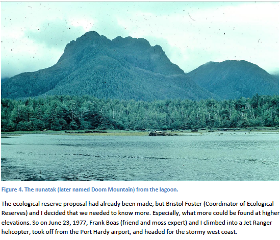 Figure 4. The nunatak (later named Doom Mountain) from the lagoon.
The ecological reserve proposal had already been made, but Bristol Foster (Coordinator of Ecological Reserves) and I decided that we needed to know more. Especially, what more could be found at higher elevations. So on June 23, 1977, Frank Boas (friend and moss expert) and I climbed into a Jet Ranger helicopter, took off from the Port Hardy airport, and headed for the stormy west coast.
Rare Surprise
The plan was to deposit the bulk of our gear at a lagoon base camp, then be ferried to a suitable campsite as high as possible in the mountains. We cached base camp supplies beneath the sheltering Sitka spruce behind the beach, and re-boarded the helicopter with backpacks and overnight supplies.
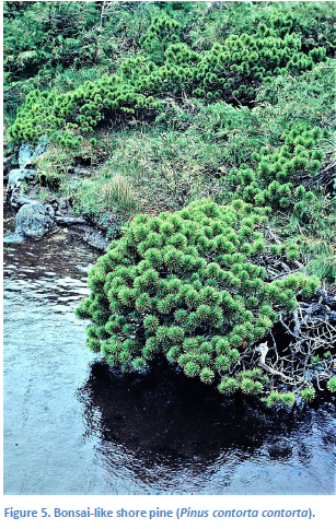 Figure 5. Bonsai-like shore pine (Pinus contorta contorta).
But by this time the southeasterly winds had stiffened, and the higher we went, the windier and cloudier it got. Our pilot nosed toward a few gaps in the curtain of cloud, but it would have been folly to attempt to force them. The wind howled over the peninsular ridge, shivering the helicopter with its force and reducing our ground speed drastically.
So we set down in muskeg at an elevation of only 400 m. The weather had frustrated our strategy, and a suitable camping spot was difficult to find in the now pouring rain. But the muskeg was fascinating; a soft mosaic of pools, rock outcrops, and dwarfed bonsai-like trees (Fig. 5), seemingly arrayed in oriental plan.
I was surprised at the abundance of Geum calthifolium, a large-flowered avens, and the small but charming alpine azalea, Loiseleuria procumbens. Both species are otherwise rather rare at high elevations in southwestern BC, but here they were commonplace. We also found several individuals of Juncus stygius var. americanus, a rush rare this far south. Bogs invariably have floral delights; here were Dodecatheon jeffreyi, looking very ‘cabbagey’; Gentiana douglasiana, a small white-flowered annual; the pale pink urns of Andromeda polifolia (bog-rosemary), and deep pink saucers of Kalmia microphylla ssp. occidentalis (bog-laurel). Scattered in the blanket bog we also found the uncommon, inconspicuous bog orchid Habenaria chorisiana, and Ligusticum calderi—just as the UBC botanists had.
Unfortunately the weather worsened and the high country looked hostile. We had no choice next morning but to shoulder our packs and hike back down to the lagoon and base camp. We set up a dry nest beneath the dense canopy of spruce and hemlock and a very large, water-tight tarp. Temperatures were mild, but clouds and rain continued to roll in off the Pacific.
Although the weather was foul, we did manage to botanize fairly thoroughly withhin a few kilometres of camp. The upper part of the long sand beach had the usual tangle of driftwood and pioneer plants. Typical beach species such as Elymus mollis (dune wild rye), Ammophila arenaria (European beach grass), Poa macrantha (seashore bluegrass), Cakile edentula (searocket), Fragaria chiloensis (Pacific 7
coast strawberry), Honkenya peploides (seabeach sandwort), and Lathyrus japonicus (beach pea) were common.
A few dunes had built up at the narrow entrance to the lagoon. There we found well-developed colonies of Carex macrocephala (big-headed sedge) and Poa macrantha, as well as scattered Glehnia littoralis ssp. leiocarpa (beach carrot) and Ambrosia chamissonis (sand-bur ragweed). We searched but found no Abronia latifolia (sand-verbena) or Calystegia soldanella (beach morning-glory), two showy-flowered dune colonists common farther south at Long Beach.
Rocky headlands were botanically rewarding, although it was very difficult to travel along the rugged coastline (Fig. 6). It was impossible to keep to the open exposed rock, for the beach-line was incised by many deep chutes and guts. But to travel through the forest we had to tunnel through nearly impenetrable thickets of Gaultheria shallon (salal). By occasionally breaking out into the open we managed to sample some bold headlands. In bloom at the time and especially attractive were Fritillaria camschatcensis, Maianthemum dilatatum (false lily-of-the-valley), Aquilegia formosa (columbine), Castilleja miniata (common paintbrush), Mimulus guttatus (common monkeyflower), Campanula rotundifolia (common harebell), and Prenanthes alata (western rattlesnake). A few of the wind-sculptured spruce bore scattered Polypodium scouleri, a tough leathery cousin of the common licorice fern (Polypodium glycyrrhiza).
Figure 6. Rugged rocky coastline, Brooks Peninsula.
In the damp shaded recesses of a box canyon along this rugged coastline we found Adiantum pedatum var. subpumilum (Fig. 7), a dwarf coastal variety of maidenhair fern. The plants clung to wet niches and crevices just a few metres above high-tide line, where they surely must be blasted by wind and salt
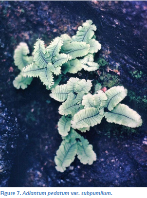 Figure 7. Adiantum pedatum var. subpumilum.
spray during storms.The tiny ferns stood merely 5-12 cm tall, and had a very close, shingled (imbricate) arrangement of their pinnules. These ferns maintained their dwarf stature in cultivation, after we brought some living plants back with us.
A miniature variety of maidenhair fern has been known to horticulturists since around 1950, and has become a popular rock garden plant. Nothing had been published about the natural occurrence of this plant, but W.H. Wagner, an authority on ferns, believes that we discovered on the Brooks Peninsula the first documented natural population of the dwarf maidenhair (Wagner and Boydston 1978). Subsequently another population was found near Tsusiat Falls, along the West Coast Trail of southwestern Vancouver Island.
Several different types of coast forest flourished in the lowlands near our camp. A Sitka spruce – western hemlock forest occupied a series of ancient beach ridges back from the present-day sand beach. Salal was the most common shrub in this forest, and there was lots of Polystichum lonchitis (sword fern) and false lily-of-the-valley.
The largest trees in the area occurred along creeks, in a spruce – redcedar – western hemlock forest type. This bottomland forest had a dense underbrush of Rubus spectabilis (salmonberry), Riibes bracteosum (stink currant), and Oplopanax horridus (devil’s-club). Graceful ferns were abundant, arranged as if in vases, including sword fern, Athyrium filix-femina (lady fern), Dryopteris assimilis (spiny wood fern), Blechnum spicant (deer fern), and ‘normal’ maidenhair fern. We also found patches of Trautvetteria caroliniensis (false bugbane), an interesting frilly-flowered member of the buttercup family, that vegetatively somewhat resembles Petasities palmatus (colt’sfoot) and favours such rich moist alluvial habitats.
Higher, well-drained, alluvial terraces supported a typical coastal forest dominated by western hemlock and amabilis fir, with lots of Vaccinium (V. alaskaense-Alaska blueberry, V. parvifolium-red huckleberry) and Menziesia ferruginea (false azalea) in the shrub layer, and a dense carpet of mosses covering the forest floor.
However, by far the dominant lowland forest was a moist cedar – hemlock type, relatively open and poorly growing. It reminded me very much of forests I had encountered on the west coast of the Queen 9
Charlottes and on the mainland coast near Prince Rupert and Bella Bella. Redcedar, yellow-cedar, and western hemlock dominated this type, with minor shore pine and amabilis fir. There was a thick shrub layer of salal, red huckleberry, Alaska blueberry, false azalea, and a fair amount of Taxus brevifolia (western yew). Deer fern, Cornus unalaschkensis (western bunchberry), false lily-of-the-valley, Coptis aspleniifolia (fern-leaved goldthread), and Calamagrostis nutkaensis (Nootka reedgrass) were among the most characteristic herbs. Epiphytes were everywhere, cloaking tree trunks and branches in thick moist bolsters.
Bogs were among the most abundant vegetation types on the Peninsula. Wet acid ‘coastal muskeg’ was widespread on poorly drained sites with shallow organic soils throughout the lowlands, and it extended as blanket or sloping bog up to 500 m on exposed ridges and mountain flanks.
Trees rarely merit the name in muskeg; poorly growing shore pine, yellow-cedar, redcedar, and western hemlock were common. Often they were stunted and bonsai-like, or had dead spike-tops.
Typical shrubs were Myrica gale (sweet gale), bog-laurel, Ledum groenlandicum (Labrador tea), Alnus viridis ssp. sinuata (Sitka alder), Juniperus communis (common juniper), and stunted salal. Dwarf shrubs included Empetrum nigrum (crowberry), bog-rosemary, alpine azalea, Vaccinium uliginosum (bog blueberry), and V. oxycoccus (bog cranberry). Common showy forbs were Fauria crista-galli (deer-cabbage), Geum calthifolium (caltha-leaved avens), Microseris borealis (bog-dandelion), Trientalis europaea ssp. arctica (bog starflower), Dodecatheon jeffreyi (Jeffrey’s shootingstar), Tofieldia glutinosa (sticky false asphodel), Gentiana sceptrum (king gentian), G. douglasiana (swamp gentian), Sanguisorba officinalis ssp. microcephala (great burnet), and Spiranthes romanzoffiana (hooded ladies’-tresses). Several species of Carex (sedges) were common but not particularly abundant. Whereas Trichophorum cespitosum (tufted clubrush), a member of the sedge family, was one of the dominant muskeg species.
An interesting feature of the hypermaritime bogs of the northwest coast (northern Vancouver Island through Southeast Alaska) is the relative lack of dominance by Sphagnum spp. (peat mosses). There is plenty of Sphagnum, to be sure, but it tends to occur in clumps and does not blanket the surface, as it does in most other acid bogs in B.C., from the lower Fraser Valley to Fort Nelson.
During one muskeg foray we stumbled to our surprise upon some flowering individuals of Camassia quamash (common camas), growing in the soaking wet bog right next to some cotton-grass. Had the camas not been in bloom, I wouldn’t have noticed it. Camas in a bog with cotton-grass! It seemed an incongruous combination, especially to two botanists who had just traveled from the sunny Garry oak groves and camas fields of Victoria.
After five days of tramping through coastal forest and squishing over muskeg, we decided to try for the high country. The weather still had not broken. The only bright sunshine of the entire trip slanted down on us at 8 pm that evening, an eerie, deep yellow light from a break in the squalls. Clouds or not, we had only two days left before we were due to be picked up. It would be tomorrow or not at all.
Next day we got an early start and made good time along a now-familiar route directly from the lagoon across an expanse of muskeg to the forested foothills of the mountains. Our plan was to head for a 10
subalpine saddle directly south of the prominent 800-m peak (later named Doom Mountain) that dominated the view from base camp.
We slogged up through wet undergrowth and around and over deadfall. It was mid-day by the time we got a clear look at the saddle. But the cloud deck soon descended and the saddle swam out of view. Although we had a compass bearing, we decided to abandon our original objective. Given the amount of ‘dreadfall’ and the poor visibility, the easiest and safest route was straight up the nunatak.
So up we went, passing through some steep montane forest of amabilis fir and western and mountain hemlock. The botany started to get more interesting when we encountered several tiers of short cliffs. We found several ferns that are relatively uncommon on Vancouver Island. Thelypteris phegopteris (beech fern), T. limbosperma (mountain wood fern), and Polystichum braunii (Braun’s holly fern) all occurred in rich soil at the base of the cliffs, and Asplenium viride (green spleenwort) grew in damp crevices. All these ferns (especially A. viride, a calciphile) prefer rich, high-hutrient soil and were somewhat of a surprise growing over parent material that appeared igneous.
Once atop the first line of cliffs the slope eased off a bit and we entered a fairly typical coastal subalpine forest of mountain hemlock, amabilis fir, and yellow-cedar, with a well-developed shrub layer of blueberries and huckleberries (Vaccinium membranaceum, V. ovalifolium, V. alaskaense, V. deliciosum), copperbush (Cladothamnus pyrolaeflorus), and Sitka mountain-ash (Sorbus sitchensis).
We were now climbing through thick fog, with no view whatsoever, except of ghostly tree trunks. The sound of falling water was ever-present. The slope steepened again and soon we were picking our way through a strange, elfin cloud forest of stunted yellow-cedar and mountain hemlock. The trees, though no taller than 5 m, formed a dense closed canopy. There were virtually no shrubs, but Calamagrostis nutkaensis formed a thick lumpy sward on the ground.
The terrain became more broken above the belt of cloud forest. Subalpine heath covered exposed ridges. Common species in the heath incuded Phyllodoce empetriformis (pink mountain-heather), Cassiope mertensiana (white mountain-heather), C. lycopodioides (club-moss mountain-heather), C. stelleriana (Alaska mountain-heather), Vaccinium deliciosum, V. uliginosum, Geum calthifolium, Empetrum nigrum, Luetkea pectinata (partridge-foot), Erigeron peregrinus (mountain daisy), Penstemon davidsonii (Davidson’s penstemon), and Gentiana platypetala. Both C. lycopodioides and G. platypetala were new species for Vancouver Island.
We soon struck the base of what, from the appearance of the vegetation, we judged to be the summit cliffs—although we could see no more than 30 m in any direction. We chose a route up a very steep slab of bedrock, which gradually narrowed to a chimney. Plants were stuck here and there along fracture lines, in niches, and on ledges. The first unusual species encountered in the chimney was Anemone narcissiflora (narcissus anemone), another northern species new to Vancouver Island. Ranunculus cooleyae (Cooley’s buttercup), uncommon this far south, was also there. Then, we inched up toward tufts of a saxifrage that I knew was different, and which upon inspection proved to be Saxifraga taylorii (Taylor’s saxifrage; Fig. 8)—one of the original QCI endemics! 11
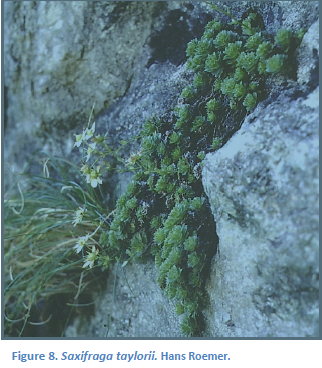 Figure 8. Saxifraga taylorii. Hans Roemer.
Figure 9. Hans Roemer and Trudy Carson, collecting and climbing on the nunatak.
This find renewed our sodden spirits, although by now it was 4 pm and mist was condensing on everything. Fortunately there was no wind but the atmosphere was cold, dank, and spooky. I doubt that we would have carried on up the chimney had we been able to see clearly its steepness and exposure. But botanists on the spoor of rare plants know little fear. We kept climbing and kept finding rare species.
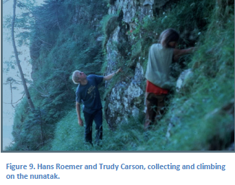 From the first Saxifraga taylorii to the summit was probably only 100 m or so in elevation gain. Over that stretch of chimney, broken ridge, and short cliffs (Fig. 9) we found two more QCI endemics, Isopyrum savilei (Queen Charlotte isopyrum) and Geum schofieldii (Queen Charlotte avens). Lloydia serotina (alp lily) was fairly frequent on moist ledges, but it was difficult to tell if the plants represented ssp. flava, a putative QCI endemic subspecies. As well we discovered a few tufts of Douglasia laevigata (smooth douglasia) and Artemisia furcata (three-forked mugwort). D. laevigata, a handsome member of the primrose family and so abundant on the Olympic Peninsula, is rare in British Columbia, previously known only from the mountains of Strathcona Park, Vancouver Island and from Moresby Mountain, QCI. A. furcata is an amphi-Beringian species that occurs on the Olympics and Mt. Rainier and in southwestern Yukon, but is very rare in BC (Douglas and Ruyle-Douglas 1978).
The highest ridges of the mountain were tricky to traverse. They were very irregular, dropped off abruptly on one side or the other, and were clothed in intricate, wind-trained krummholz (Fig. 10). Sometimes we found it impossible to step on the ridgerock itself and had to walk atop the stiff krummholz, which easily bore our weight. 12
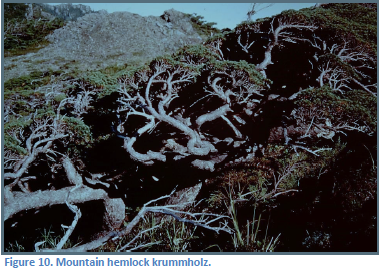 Figure 10. Mountain hemlock krummholz.
Figure 11. Wind-blasted ridges, Brooks Peninsula. Hans Roemer.
The summit foraging took us about two hours and to 6 pm. We decided it was past time to get off the nunatak. We had several cliffs to descend and the fog obviously was not going to lift.
It was 9 pm by the time we stumbled back to the head of the lagoon. The tide was up and over the fringing salt marsh where we usually walked. Already soaked, we slogged through thigh-deep seawater along the lagoon edge rather than bushwhack through the forest. Back at camp we tugged off wet clothes, spooned some cold corned beef out of tins, and crawled into sleeping bags—tired, but elated with our discoveries.
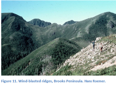 A little more than a year later, Trudy Carson, Bristol Foster, and Hans Roemer visited the Peninsula, on another expedition sponsored by the Ecological Reserves program. They were blessed with fine weather, thus were able to reach the high ridges in ideal conditions (Fig. 11). They found most of the same rare plants as we had, and additionally collected Calamagrostis purpurascens ssp. tasuensis (a small purplish reedgrass), Galium kamtschaticum (northern wild licorice), and Artemisia arctica (mountain sagewort). The subspecies of C. purpurascens formerly was thought to be endemic to the Queen Charlotte Islands; both G. kamtschaticum and A. arctica are new to the flora of Vancouver Island.
Discussion
The floristic evidence (including that from the bryoflora, which I have not discussed (see Godfrey & Godfrey 1979) supports the notion of a Pleistocene refugium on the Brooks Peninsula (Pojar 1980). 13
More rarities could still be found; combined botanical collecting time in the lucrative high elevations has totalled probably less than six hours. Maybe someone will find Senecio newcombei, the most abundant of the endemics on the Queen Charlotte Islands, but which hasn’t been discovered anywhere else.
Saxifraga ferruginea (rusty saxifrage) provides an additional cytogeographic tidbit. K.I. Beamish counted the chromosomes of a specimen from the Peninsula and found their number to be diploid, just as it was from populations south of the presumed margin of Pleistocene ice and also from proposed refugia on Kodiak Island and on the Queen Charlottes (Randhawa and Beamish 1972). Elsewhere only polyploids have been found, all within the range of Pleistocene glaciation.
The location, relief, and terrain of the Brooks Peninsula all suggest a refugium. Moreover, late-glacial sea levels on the west coast o f Vancouver Island were up to 130 m lower than they are today; potential refugia could have been today’s land surface would indicate. Yet until recently, published geological arguments have invoked the ‘tabula rasa’ interpretation for all of coastal BC—including the Queen Charlotte Islands (Brown and Nasmith 1962)—save for a few of the highest summits. That is, the ice mass was believed to have covered virtually the entire countryside (see Prest 1969) and destroyed all plant and animal life. However, recent geological data from the western end of the Strait of Juan de Fuca, west coast of Vancouver Island, and Queen Charlotte Sound suggest that glaciation during the Vashon advance was incomplete and did not always reach the edge of the continental shelf.
Fladmark (1975, 1979) has proposed a chain of sea-level refugia along the north Pacific coast of North America, as a migration corridor from Beringia to southern North America during the late Pleistocene. He suggested that there is a high probability that major portions of the BC coast were ice free throughout the Fraser Glaciation, and that humans could have lived in these areas for over 40,000 years. As Fladmark (1975) wrote, “In total, it seems more logical to visualize the Pleistocene Northwest Copast as somewhat analagous to modern Greenland with an interior ice-sheet spilling out to the sea only though major transverse valleys, rather than a land totally embraced within a single untopographically controlled ice-cap”. It also seems logical to visualize Pleistocene vegetation surviving on wet coastal headlands and mountains, flanked but not over-ridden by ice lobes, and harbouring many of the same species we encountered 20,000 years later.
Epilogue
The British Columbia Provincial Museum (now Royal B.C. Museum) in 1981 organised a large-scale, multidisciplinary expedition to the Brooks Peninsula. Led by botanist Richard Hebda and archaeologist Jim Haggarty, the “focus of the expedition was to determine whether the Brooks Peninsula, or parts of it, escaped glaciation during the last major ice advance on the coast” (Hebda and Haggarty 1997). The research team investigated bedrock and Quaternary geology, soils, vascular and non-vascular plants, cytogeography, vegetation and paleoecology, vertebrate and inverterbrate fauna, archaeology, and ethnographic history. Conclusion: “… taken together physical and biotic obervations provide strong evidence for a Fraser Glaciation refugium encompassing high elevations of Brooks Peninsula” (Hebda and Haggarty 1997). 14
Literature Cited
Brown, A.S. and H. Nasmith. 1962. The glaciation of the Queen Charlotte Islands. Canadian Field-Naturalist 76: 209-218.
Calder, J.A. and R.L. Taylor. 1968. Flora of the Queen Charlotte Islands. Part 1. Systematics of the vascular plants. Canada Department of Agriculture Monograph 4. 659 p.
Dahl, E. 1946. On different types of unglaciated areas during the ice ages and their significance to phytogeography. New Phytologist 45: 225-242.
Douglas, G.W. and G. Ruyle-Douglas. 1978. Contributions to the floras of British Columbia and the Yukon Territory. I. Vascular plants. Canadian Journal of Botany 56: 2296-2302.
Fladmark, K. 1975. A paleoecological model for northwest coast prehistory. Archaeological Survey of Canada. Paper Number 43.
Fladmark, K. 1979. Routes: alternate migration corridors for early man in North America. American Antiquity 44: 55-69.
Foster, J.B. 1965. The evolution of the mammals of the Queen Charlotte Islands, British Columbia. Occasional Paper 14, B.C. Provincial Museum, Victoria, BC.
Godfrey, J.D. and G.A. Godfrey. 1979. Jungermannia schusterana, a new hepatic from the Pacific Coast of North America. Journal of the Hattori Botanical Laboratory 46: 109-117.
Hebda, R.J. and J.C. Haggarty, editors. 1997. Brooks Peninsula: An ice age refugium on Vancouver Island. Occasional Paper Number 5. BC Parks, Ministry of Environment, Lands and Parks, and Royal BC Museum Victoria, BC. 484 p. https://www.for.gov.bc.ca/hfd/library/documents/Bib42003.pdf
Heusser, C.J. 1960. Late-Pleistocene environments of North Pacific North America. American Geographic Society Special Publication 35.
Karlstrom, T.N.V. and G.E. Ball, editors. 1969. The Kodiak Island refugium: its geology, flora, fauna and history. Ryerson Press, Toronto.
Pojar, J. 1980. Brooks Peninsula: possible Pleistocene glacial refugium on northwestern Vancouver Island. Botanical Society of America Misc. Ser. Publ. 158: 90.
Prest, V.K. 1969. Retreat of Wisconsin and recent ice in North America. Map1257A, Geological Survey of Canada, Ottawa.
Randhawa, A.S. and K.I. Beamish. 1972. The distribution of Saxifraga ferruginea and the problem of refugia in northwestern North America. Canadian Journal of Botany 50: 79-87.
Wagner, W.H. and K.E. Boydston. 1978. A dwarf coastal variety of maidenhair fern, Adiantum pedatum. Canadian Journal of Botany 56: 1726-1729.