
2018 Bowser Ecological Reserve
Wardens’ Annual Report by Gerry van der Wolf on behalf of Bill Image and Peter Spodzieja
January 9
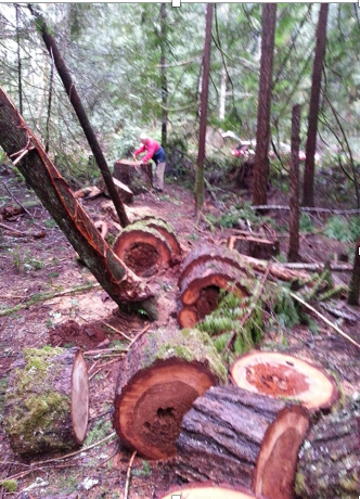
Bill and Gerry arrived at the ER in the early afternoon, noted more yard waste dumped at the main gate, then checked the plantation road to the fork at 1.8 km. We noted several locations where large Douglas Firs had been recently cut down and cut up into lengths. Some wood had been removed. The activity was photographed and reported. Parking at the .5 decommissioned road we hiked a loop, first to the trail camera where the batteries were replaced, then back via the gravel pit road and plantation road. Our input was sought in developing the news release announcing the fine for the individual having illegally cut the trees.
February 10
Bill and Gerry arrived at the ER in the mid-morning, noted a dead racoon in a plastic bag as well as more yard waste at the main gate. We checked the plantation road to the fork at 1.8 km. noting that a mid-sized Hemlock had been cut and removed along the route. We took pictures and Bill reported the activity. Parking at the .5 km. decommissioned road we walked in, retrieved the memory card from the trail camera. There were no pictures captured so we took the camera for re-positioning on a well used game trail. We completed the loop for a total of 4.67 km.
March 12
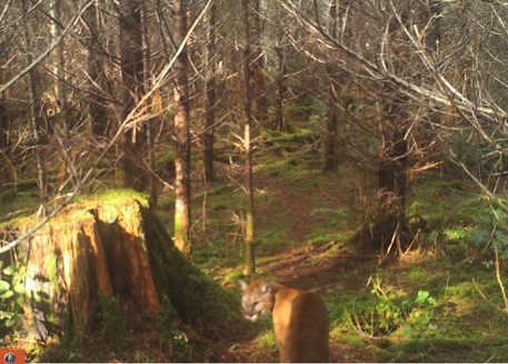
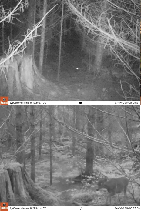
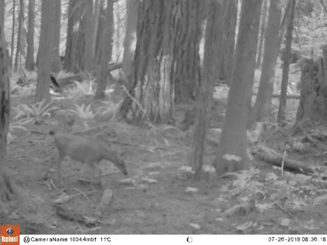
Bill and Gerry arrived at the ER in the mid-morning, met Peter at the gate who proceeded to walk to the 1.5 km. point. Bill and Gerry then checked the plantation road to the fork at 1.8 km. We noted that a small Douglas Fir had been cut and removed at the 1.5 km. point. Parking at the decommissioned road at .5 km. we hiked in and measured large Douglas Firs, one 20’ 4”, the second one 17’ 2”, the third 19’ 6” in diameter. We checked the hollow tree where there were no signs of recent activity. We changed the memory card and remounted the trail camera. There were daytime cougar pictures captured. The beaver pond was visited where we noted eggs masses.
 April 17
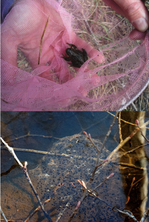
Bill and Gerry arrived at the ER in the mid-morning, met Peter, checked the plantation road to the fork at 1.8 km. Parking at the gravel pit road at 1.1 km. we walked in to the first fork then headed to the trail camera where we changed the memory card then photographed a salamander along the way to the beaver pond. There we netted and photographed a small frog as well a taking pictures of egg masses.
There was a nighttime picture of a marten as well as daytime and nighttime pictures of deer on the memory card.
May 11
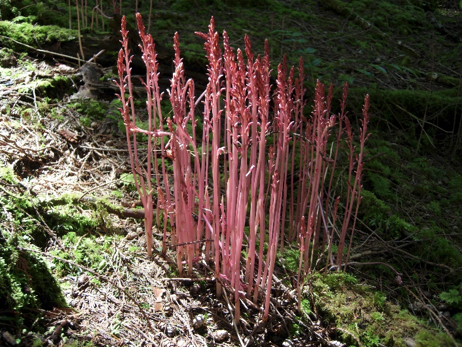
Bill and Gerry arrived at the ER in the mid-morning, met Peter and David Webb, a prospective Warden. We checked the plantation road to the fork at 1.8 km. Parking at the decommissioned road at .2 km. a counter clockwise loop was walked through the berry patch where we noted all the tagged bushes, and the squirrel feast areas where a large Douglas Fir was measured. Photos were taken of a reddish coloured, thin, upright, fungi resembling asparagus. David advises later that he has decided to focus his volunteer efforts elsewhere.
June 19
Bill and Gerry arrived at the ER in the mid-morning, met Peter at the gate, checked the plantation road to the fork at 1.8 km. Peter walked the plantation road to the 1.5 km. point where he found bear scat and elk tracks. Parking at the gravel pit road at 1.1 km., a route to Cook Creek was walked by Bill and Gerry, then the beaver pond was checked on the way back for a total of 4.3 km. The camera was removed as the batteries were low. A daytime picture of a marten, nighttime pictures of a cougar, and daytime pictures of deer were captured.
July 24
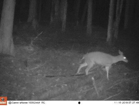
Bill and Gerry arrived at the ER in the mid-morning, met Peter who walked the road to 1.5 km. Bill and Gerry checked the plantation road to the fork at 1.8 km. Parking at the decommissioned road at .2 km. Bill and Gerry went first to the berry patch, measured the stems and counted the berries, then walked to a point near the reserve boundary, positioning the camera, then completing the counter clockwise loop for a total of 4.9 km. There were no squirrel signs and Peter had no incidents to report. There were nighttime pictures of deer captured.
August 5
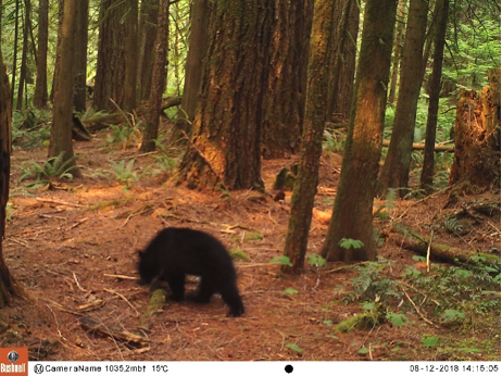
Bill parked at the decommissioned road at .2 km. and walked to the Huckleberry patch to collect berries then walked back to the vehicle for a total of 1.7 kilometers. There was a daytime picture of a black bear captured.
 September 5
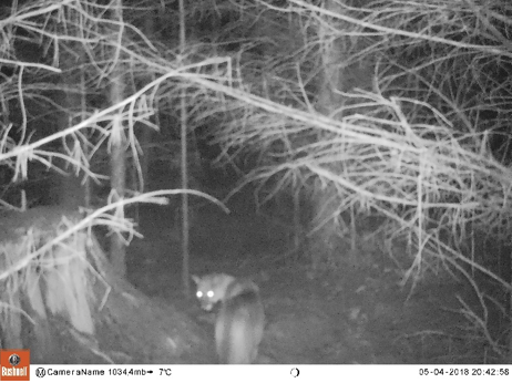
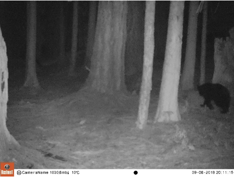
Bill and Gerry arrived at the ER in the mid-morning, checked the plantation road to the fork at 1.8 km. A loop to the trail camera was hiked over three hours. There was a nighttime picture of a black bear captured.
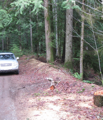
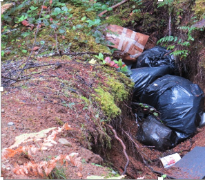
Peter traveled the plantation road September 13 and took pictures of significant garbage by the roadside, which was reported.
 October 27
Gerry and Chris, who has been recruited to replace Bill who has moved to Vernon, arrived at the ER in the mid-morning, checked the plantation road to the fork at 1.8 k. Parking at the decommissioned road at .2 km. we walked to retrieve the camera. There were nighttime pictures of deer captured. The camera was taken for relocation at a site at the end of the gravel pit road, at an old logged area. A red squirrel was seen along the way. The clockwise loop was completed along the gravel pit road and the plantation road for a total of a three-hour hike. An older model beige Dodge van camper conversion drove by; it has often been seen on the plantation road and appears to be a local walking his dog.
November 30
Gerry and Chris arrived at the ER in the mid-morning, noted a blue Mazda sedan parked at the gate, and a woman with a clip board nearby, then checked the plantation road to the fork at 1.8 km. A counter clockwise loop was walked starting at the decommissioned road at .2 km., the camera was checked. There were no pictures captured. A red squirrel was seen along the way. The loop was completed along the gravel pit road and the plantation road for a total of a three-hour hike.
December 30
Gerry and Chris arrived at the ER in the mid-morning, noted the same blue Mazda parked at the gate, checked the plantation road to the fork at 1.8 km., noting a deer carcass and cardboard in one of the roadside swales, as well as a medium sized Douglas Fir having been cut and removed from the roadside. Photos were taken and the coordinates noted. The tree cutting was reported by text to the assigned phone number by Gerry. A silver-grey Toyota Tacoma passed us on the road but was not seen again further on; it must have continued to the left past the fork at 1.8 km. Parking at the gravel pit road at 1.1 km., the camera was recovered, there were no pictures captured. The camera was taken for re-positioning and a clockwise loop was walked to the Cougar Cam waypoint where the camera was mounted. The 6.4 km. loop back to the gravel pit was completed for a total of a three-hour hike.

General Comments
Invasive species of plants including holly and Scotch Broom are removed whenever encountered. Small amounts of garbage are removed when encountered. Larger amounts or heavier items of garbage are reported for removal. Additional signage for the reserve is recommended. Locking the gate to prevent illegal dumping and tree cutting is recommended.
Respectfully submitted by Gerry van der Wolf
On behalf of Bill Image and Peter Spodzieja