
Ecological Reconnaissance of
BCTS Blocks A93884 and A91376 near Roberts Creek and Gibsons, B.C.
for Elphinstone Logging Focus (ELF)
See the complete pdf here:A_Banner_Elphinstone-Logging-Focus-July-04_2018-1-1
Field Investigation: May 10-12, 2018
 Report Date: July 4th, 2018
Allen Banner MSc., RPBio, RPF (ret)
Banner Consulting
Smithers, B.C.
Background
- • Elphinstone Logging Focus (ELF) requested my expertise in assessing the occurrence of red- and blue-listed forested plant communities within proposed logging blocks on the slopes of Mt. Elphinstone near the communities of Roberts Creek and Gibsons, B.C. ELF has expressed concerns in the past about red-and blue-listed ecosystems not being properly represented/conserved on the Sunshine Coast. This led to a Forest Practices Board (FPB) investigation beginning in 2016 with a final report in 2018 (Forest Practices Board 2018). I was retained by the FPB as the investigating ecologist for that investigation of block A87125 which has now been harvested. Background information on the Mt. Elphinstone study area and methods used in this current assessment are drawn from my earlier FPB field assessment report (Banner 2016).
- • The FPB report resulting from the 2016 investigation (Forest Practices Board 2018) had 3 recommendations with a response deadline of June 30th, 2018: 1) Government should provide legal objectives or guidance for managing the amount and distribution of these plant communities in the TSA; 2) Government should update the list of plant communities in the Identified Wildlife Strategy; and 3) BCTS should revise its protocol to include consideration of younger occurrences of plant communities.
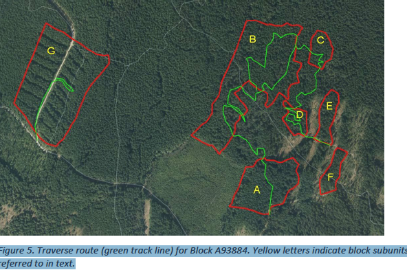
- • In the mean time, additional logging blocks are being prepared for harvest on BCTS’s 5- year operating plan and ELF is specifically concerned about two blocks scheduled for harvest in 2018 on the slopes of Mt. Elphinstone (Figure 1 and 2). Block A93884 (previously A87126), approximately 53 ha in area (including eight subunits), occurs off the Roberts Flume FSR between East Wilson Creek and Clack Cr., north of the community of Roberts Creek. Block A91376, approximately 29 ha in area, occurs off Reed Road, north, and adjacent to, the community of Gibsons.
2
- • ELF has similar concerns that these two blocks may contain significant areas of red- and blue-listed plant communities as designated by the B.C. Conservation data Centre. They feel that the conservation of these rare/threatened forest types on the slopes of Mt. Elphinstone within the Chapman Landscape Unit remains inadequate.
- • Block A93884 (Clack Cr. Block) occurs within the 2137 ha expansion proposal for Elphinstone Provincial Park (McCrory 2015)1. This park proposal is included within the Roberts Creek Official Community Plan (Bylaw No. 641, 2011; Map 2 Parks and Trails) of the Sunshine Coast Regional District (SCRD) (http://www.scrd.ca/files/File/Community/Planning/RC%20OCP%20review/Map2_AreaD_ParksTrails.pdf).
1 As described in McCrory 2015, the “Elphinstone 1500” original park proposal dating back over 20 years, was based on an estimated 1500 ha area that was later revised, through more detailed GIS analysis by Baden Cross, Applied Conservation GIS, to 2,137 ha of public land, including 139 ha (6.5%) that is currently protected in three small provincial parks.
- • Block A91376 (Reed Road Block) occurs within District Lot DL1313 which is designated as “Park” on the Elphinstone Official Community Plan (Bylaw No. 600; Map3 Land Use Designations) of the SCRD (Sunshine Coast Regional District Staff Report 2016; http://www.scrd.ca/files/File/Community/Planning/Area%20E%20OCP/Elphinstone%20OCP%20Map3_AreaE_LU%20-%20March%2010%2C%202015.pdf), though acquisition and official designation as a Park by the SCRD has not yet occurred. DL1313 is also designated as Gibsons Watershed Reserve (B.C. Land Act designation) on published maps (MapArt Publishing 2002).
- • The study blocks occur within the traditional territories of the Sechelt (Shíshálh) and Squamish (Skwxwú7mesh) First Nations.
- • The CDC establishes and maintains the provincial list of elements at risk (B.C. Conservation Data Centre, BC Species and Ecosystems Explorer website), including ecological communities (the red and blue lists or “listed communities”), in order to assist land planners and managers with managing for biodiversity on crown and private land. However, there is no blanket provincial legislation for protection of these listed communities. Recent legislation governing the Great Bear Rainforest (B.C. Ministry of Forests, Lands, and Natural Resource Operations 2016) does specify specific protection measures for red listed (100% protection) and blue listed (70%) ecosystems and a guidance document for implementing this legislation is currently being developed (I am involved in that initiative). Legally binding Landscape Unit Plans (LUPs) also incorporate, to varying degrees, listed communities. For example, the Chapman LUP (B.C. Ministry of Sustainable Resource Management 2002), which includes the study blocks, explicitly mentions red listed (but not blue listed) ecosystems, utilizing the sensitive ecosystem inventory information described below. Some voluntary corporate initiatives are
3
- currently underway in the province to manage for listed ecosystems (e.g., Western Forest Products; Banner et al. 2014). BCTS has a policy that deals mainly with red-listed ecosystems, currently focussing on conserving old-growth examples (>250 years old); however, as a result of the recent FPB report (Forest Practices Board 2018), some modifications to that policy may be underway.
- • The CDC utilizes an international assessment system developed by NatureServe (B.C. Ministry of Environment 2006) to assess the quality of ecological community element occurrences (EOs). EOs are assessed based on three factors; condition, landscape context, and size, in order to calculate a final EO rank of excellent, good, fair, or poor. The assessment provided here will utilize this approach as further described below. A copy of the assessment procedure is provided for reference in Appendix 1.
- • A sensitive ecosystems inventory (SEI) of the Sunshine Coast and adjacent islands was completed by the B.C Ministry of Environment between 2000 and 2005 (B.C. Ministry of Environment 2005). Thirty-eight 1:20,000 mapsheets were produced (available at: http://a100.gov.bc.ca/pub/acat/public/viewReport.do?reportId=3758. Mapsheets 92G.042 and 043 cover the slopes of Mt. Elphinstone and portions of these mapsheets, including the two study blocks, are shown in Figures 3 and 4. The maps incorporate the red and blue listed ecosystems, in addition to other unlisted but sensitive sites, into broad sensitive ecosystem map units, including old forest, woodland, herbaceous, riparian, wetland, and cliff units. A mature forest category is also mapped under the category “other important ecosystems”. In addition to these broad ecosystem units, each polygon is also assigned a label denoting the composition of site units (site series and structural stages). It is important to note that the SEI mapping was based largely on air photo interpretation with 20% of polygons being ground truthed with ecosystem plots. Table 1 provides the SEI polygon composition for the polygons overlapping the two proposed logging blocks. These map labels will be further discussed below and compared with what was found in our field assessment.
- • Terrestrial Ecosystem Mapping (TEM) has also been completed for the Chapman landscape Unit (Timberline Natural Resource Group 2008). Reports describing this mapping are available on the Ministry of Environment Ecological Reports Catalogue (EcoCat) site (http://a100.gov.bc.ca/pub/acat/public/viewReport.do?reportId=35894); however, digital map files for that project were not available for download from the EcoCat site so could not be examined for this study.
- • The proposed logging blocks are located within the Coastal Western Hemlock biogeoclimatic zone, dry, maritime subzone (CWHdm). According to the CDC website and the SEI maps, all of the forested site series within the CWHdm support either red- or blue-listed ecological communities and the same situation holds for the CWHxm (very dry maritime) occurring at lower elevations in the study area. The SEI maps highlight the scarcity of old forest polygons within the CWHdm and xm (a few small polygons on mapsheets 92G.042 and 43). Mature forest polygons are considerably more common
4
- and larger but still of limited extent on the slopes of Mt. Elphinstone. Note that while all site series in the CWHdm and xm support either red or blue listed ecosystems, the SEI maps only show polygons for the mature and old forest structural stages as these are the stages deemed to represent the rare/at risk seral stages within these subzones.
- • Human development and forest harvesting, in combination with a more frequent historical fire history, in these and other southern CWH subzones have resulted in older forest age classes being significantly reduced in area, compared with CWH subzones to the north and at higher elevations (e.g., the CWHvm). While some site series and their older age classes are naturally rare/at risk because they are associated with restricted environmental factors (e.g., riparian sites), others are widespread (e.g., CWHdm/01, covering 50+ % of the landscape) but rarity of older age classes within these site series has been induced, largely by human activity over the past century. Within the entire CWHdm of the Chapman Landscape Unit, mature and old forest encompass 42% and 3% respectively of the total forest area (B.C. Ministry of Sustainable Resource Management 2002).
- • The CWHdm occurs within Natural Disturbance Type 2 (NDT2) where stand replacing disturbances such as fire are infrequent and the natural disturbance ‘average’ return interval is approximately 200 years (Biodiversity Guidebook; Province of B.C. 1995). This is in comparison to wetter subzones of the CWH (e.g., CWHvm), classified as NDT1, with rare stand initiating events and longer average return intervals (250+ years; 500-1000+ years on the outer north coast). As a result, very old forests (>250 years old) are naturally less extensive in the CWHdm (in addition to being further reduced by human activity) compared with wetter CWH subzones to the north and at higher elevations.
- • The References section lists additional documents utilized in my assessment of the ecosystems within the study area.
-
Ecological Reconnaissance of
BCTS Blocks A93884 and A91376 near Roberts Creek and Gibsons, B.C.
for Elphinstone Logging Focus (ELF)
Field Investigation: May 10-12, 2018
Report Date: July 4th, 2018
Allen Banner MSc., RPBio, RPF (ret)
Banner Consulting
Smithers, B.C.
Background
- • Elphinstone Logging Focus (ELF) requested my expertise in assessing the occurrence of red- and blue-listed forested plant communities within proposed logging blocks on the slopes of Mt. Elphinstone near the communities of Roberts Creek and Gibsons, B.C. ELF has expressed concerns in the past about red-and blue-listed ecosystems not being properly represented/conserved on the Sunshine Coast. This led to a Forest Practices Board (FPB) investigation beginning in 2016 with a final report in 2018 (Forest Practices Board 2018). I was retained by the FPB as the investigating ecologist for that investigation of block A87125 which has now been harvested. Background information on the Mt. Elphinstone study area and methods used in this current assessment are drawn from my earlier FPB field assessment report (Banner 2016).
- • The FPB report resulting from the 2016 investigation (Forest Practices Board 2018) had 3 recommendations with a response deadline of June 30th, 2018: 1) Government should provide legal objectives or guidance for managing the amount and distribution of these plant communities in the TSA; 2) Government should update the list of plant communities in the Identified Wildlife Strategy; and 3) BCTS should revise its protocol to include consideration of younger occurrences of plant communities.
- • In the mean time, additional logging blocks are being prepared for harvest on BCTS’s 5- year operating plan and ELF is specifically concerned about two blocks scheduled for harvest in 2018 on the slopes of Mt. Elphinstone (Figure 1 and 2). Block A93884 (previously A87126), approximately 53 ha in area (including eight subunits), occurs off the Roberts Flume FSR between East Wilson Creek and Clack Cr., north of the community of Roberts Creek. Block A91376, approximately 29 ha in area, occurs off Reed Road, north, and adjacent to, the community of Gibsons.
2
- • ELF has similar concerns that these two blocks may contain significant areas of red- and blue-listed plant communities as designated by the B.C. Conservation data Centre. They feel that the conservation of these rare/threatened forest types on the slopes of Mt. Elphinstone within the Chapman Landscape Unit remains inadequate.
- • Block A93884 (Clack Cr. Block) occurs within the 2137 ha expansion proposal for Elphinstone Provincial Park (McCrory 2015)1. This park proposal is included within the Roberts Creek Official Community Plan (Bylaw No. 641, 2011; Map 2 Parks and Trails) of the Sunshine Coast Regional District (SCRD) (http://www.scrd.ca/files/File/Community/Planning/RC%20OCP%20review/Map2_AreaD_ParksTrails.pdf).
1 As described in McCrory 2015, the “Elphinstone 1500” original park proposal dating back over 20 years, was based on an estimated 1500 ha area that was later revised, through more detailed GIS analysis by Baden Cross, Applied Conservation GIS, to 2,137 ha of public land, including 139 ha (6.5%) that is currently protected in three small provincial parks.
- • Block A91376 (Reed Road Block) occurs within District Lot DL1313 which is designated as “Park” on the Elphinstone Official Community Plan (Bylaw No. 600; Map3 Land Use Designations) of the SCRD (Sunshine Coast Regional District Staff Report 2016; http://www.scrd.ca/files/File/Community/Planning/Area%20E%20OCP/Elphinstone%20OCP%20Map3_AreaE_LU%20-%20March%2010%2C%202015.pdf), though acquisition and official designation as a Park by the SCRD has not yet occurred. DL1313 is also designated as Gibsons Watershed Reserve (B.C. Land Act designation) on published maps (MapArt Publishing 2002).
- • The study blocks occur within the traditional territories of the Sechelt (Shíshálh) and Squamish (Skwxwú7mesh) First Nations.
- • The CDC establishes and maintains the provincial list of elements at risk (B.C. Conservation Data Centre, BC Species and Ecosystems Explorer website), including ecological communities (the red and blue lists or “listed communities”), in order to assist land planners and managers with managing for biodiversity on crown and private land. However, there is no blanket provincial legislation for protection of these listed communities. Recent legislation governing the Great Bear Rainforest (B.C. Ministry of Forests, Lands, and Natural Resource Operations 2016) does specify specific protection measures for red listed (100% protection) and blue listed (70%) ecosystems and a guidance document for implementing this legislation is currently being developed (I am involved in that initiative). Legally binding Landscape Unit Plans (LUPs) also incorporate, to varying degrees, listed communities. For example, the Chapman LUP (B.C. Ministry of Sustainable Resource Management 2002), which includes the study blocks, explicitly mentions red listed (but not blue listed) ecosystems, utilizing the sensitive ecosystem inventory information described below. Some voluntary corporate initiatives are
3
- currently underway in the province to manage for listed ecosystems (e.g., Western Forest Products; Banner et al. 2014). BCTS has a policy that deals mainly with red-listed ecosystems, currently focussing on conserving old-growth examples (>250 years old); however, as a result of the recent FPB report (Forest Practices Board 2018), some modifications to that policy may be underway.
- • The CDC utilizes an international assessment system developed by NatureServe (B.C. Ministry of Environment 2006) to assess the quality of ecological community element occurrences (EOs). EOs are assessed based on three factors; condition, landscape context, and size, in order to calculate a final EO rank of excellent, good, fair, or poor. The assessment provided here will utilize this approach as further described below. A copy of the assessment procedure is provided for reference in Appendix 1.
- • A sensitive ecosystems inventory (SEI) of the Sunshine Coast and adjacent islands was completed by the B.C Ministry of Environment between 2000 and 2005 (B.C. Ministry of Environment 2005). Thirty-eight 1:20,000 mapsheets were produced (available at: http://a100.gov.bc.ca/pub/acat/public/viewReport.do?reportId=3758. Mapsheets 92G.042 and 043 cover the slopes of Mt. Elphinstone and portions of these mapsheets, including the two study blocks, are shown in Figures 3 and 4. The maps incorporate the red and blue listed ecosystems, in addition to other unlisted but sensitive sites, into broad sensitive ecosystem map units, including old forest, woodland, herbaceous, riparian, wetland, and cliff units. A mature forest category is also mapped under the category “other important ecosystems”. In addition to these broad ecosystem units, each polygon is also assigned a label denoting the composition of site units (site series and structural stages). It is important to note that the SEI mapping was based largely on air photo interpretation with 20% of polygons being ground truthed with ecosystem plots. Table 1 provides the SEI polygon composition for the polygons overlapping the two proposed logging blocks. These map labels will be further discussed below and compared with what was found in our field assessment.
- • Terrestrial Ecosystem Mapping (TEM) has also been completed for the Chapman landscape Unit (Timberline Natural Resource Group 2008). Reports describing this mapping are available on the Ministry of Environment Ecological Reports Catalogue (EcoCat) site (http://a100.gov.bc.ca/pub/acat/public/viewReport.do?reportId=35894); however, digital map files for that project were not available for download from the EcoCat site so could not be examined for this study.
- • The proposed logging blocks are located within the Coastal Western Hemlock biogeoclimatic zone, dry, maritime subzone (CWHdm). According to the CDC website and the SEI maps, all of the forested site series within the CWHdm support either red- or blue-listed ecological communities and the same situation holds for the CWHxm (very dry maritime) occurring at lower elevations in the study area. The SEI maps highlight the scarcity of old forest polygons within the CWHdm and xm (a few small polygons on mapsheets 92G.042 and 43). Mature forest polygons are considerably more common
4
- and larger but still of limited extent on the slopes of Mt. Elphinstone. Note that while all site series in the CWHdm and xm support either red or blue listed ecosystems, the SEI maps only show polygons for the mature and old forest structural stages as these are the stages deemed to represent the rare/at risk seral stages within these subzones.
- • Human development and forest harvesting, in combination with a more frequent historical fire history, in these and other southern CWH subzones have resulted in older forest age classes being significantly reduced in area, compared with CWH subzones to the north and at higher elevations (e.g., the CWHvm). While some site series and their older age classes are naturally rare/at risk because they are associated with restricted environmental factors (e.g., riparian sites), others are widespread (e.g., CWHdm/01, covering 50+ % of the landscape) but rarity of older age classes within these site series has been induced, largely by human activity over the past century. Within the entire CWHdm of the Chapman Landscape Unit, mature and old forest encompass 42% and 3% respectively of the total forest area (B.C. Ministry of Sustainable Resource Management 2002).
- • The CWHdm occurs within Natural Disturbance Type 2 (NDT2) where stand replacing disturbances such as fire are infrequent and the natural disturbance ‘average’ return interval is approximately 200 years (Biodiversity Guidebook; Province of B.C. 1995). This is in comparison to wetter subzones of the CWH (e.g., CWHvm), classified as NDT1, with rare stand initiating events and longer average return intervals (250+ years; 500-1000+ years on the outer north coast). As a result, very old forests (>250 years old) are naturally less extensive in the CWHdm (in addition to being further reduced by human activity) compared with wetter CWH subzones to the north and at higher elevations.
- • The References section lists additional documents utilized in my assessment of the ecosystems within the study area.