
Page 1 of 11
ER #76 Fraser River – March 6, 2022
Report by Bill and Bev Ramey
Sunshine, 9 to 12 o C, light breeze increasing to SSW 11km/hr around 3 pm
Launch kayaks from Nicomen Island 9:30 am, return 5:00 pm
Walking distance about 12 km
Water level at Mission: 0.5 to 1.5 metres (tidal)
Water level at Hope: 3.49 metres
Participants: EcoReserve Wardens Bill and Bev Ramey
Great news – the Ecological Reserve Islands are still there, having withstood the
November floods! Those floods resulted from the ‘Atmospheric River’ downpours
that lasted several days and flooded the old lake bed at nearby Sumas Prairie, as
well as parts of Merritt, the Nicola River, Coquihalla and Skagit. However, the
gauge records of the Fraser River water level at Hope during the November floods
show that it was not as high as the annual Fraser River freshet. The 2021
November flood peak measured 6.9 metres at the Hope gauge, while the June 2021
annual freshet peak was higher at 8.8 metres. But lower down on the Fraser, at
Mission, the gauge reading was relatively high during the November flooding, at a
similar level to the June freshet. This makes sense as the Mission gauge is located
downriver from the huge flooding input last November from the Chilliwack/Vedder
and Sumas Rivers. The Fraser River ER#76 islands are located above where the
Chilliwack/Vedder/Sumas Rivers flow into the Fraser.
The erosion of the riprap along the shoreline of Nicomen Island where we launch
has accelerated and now a distance of about 100 metres of shoreline riprap has
been washed out and caved into the river bed out of sight. For a short distance the
underlying membrane tarp remains on the slope, but the riprap rocks that had been
placed on it are gone.
The Ecological Reserve islands have fared well over the past year as there has been
minimal losses of the eroding south and southeastern facing shorelines of the
islands and as well there is a gravel bar forming a short distance offshore, visible at
today’s lower water level. Hopefully in the years to come this gravel bar might help
protect this shoreline from erosion. The islands look to have benefited from the
upriver November flood erosion, that is, the north and northwestern accreting sides
of the islands have had their height increased considerably with deposits of sand,
silt and clays. The volume of deposited sediments is enormous. A very rough
estimate is in the order of 15,000 gravel truck loads! (This crude estimate is based
on 16.5 cubic yards per gravel truck, and area filled is about 1000 yards x 500
yards x .5 yard deep). Sand, silt, and clay have been deposited based on location
relative to the river flow and whether in back-eddies, main channels or slower-flow
channels, as well as location as the flood levels resided. The height increase of
deposits has been estimated based on filling that has taken place adjacent to what
had been a bank that rose steeply upwards (about a metre in height) to the
vegetated islands of horsetail, willow and cottonwood. Now with the new sediment
deposits, the river bed is almost the same level as the vegetated islands. In
addition, where colonizing vegetation of cottonwoods or willows, had been
Page 2 of 11
vegetating the river bed, these young trees now have sand deposits rising up their
small trunks and their lower branches now arise from below the new surface of the
sand. Another visible feature of the filling/depositing of flood sediments is that two
of the major inner channels that formerly had gravels and small pools, interspersed
with bunch grasses growing in the gravels, are now filled with deposits of silts and
clays, again reducing the channel bank height up to almost the level of their
horsetails, shrubs and trees. These sediments would have settled out from the fast
flowing Fraser River as it reached the slower flowing reach where the Ecological
Reserve islands are located. That is, the gradient of the river flow gradually slows
downriver from Hope, and especially at the ER islands, as here the Fraser can
expand to its widest width, about 1.5 kilometres across from mainland dykes on its
southern and northern shores.
You may well ask, why are these un-dyked islands important ecologically? From the
perspective of geomorphology, they help slow the force of the flooding Fraser. From
the perspective of fish habitat, these un-dyked islands make valuable contributions
of both food and habitat. Recent studies by Mike Pearson et al (2021 Freshet
Sampling as reported to the February 2022 Heart of the Fraser Strategy Session),
documented the value of un-dyked Fraser River shorelines to fish, when their
vegetation floods during the May-June freshet. When the vegetated shores flood,
many insects become available for food for fish. Many small fish (fry and smolts)
need the quieter waters of back channels, eddies and flooded swales to successfully
increase in size. Main stream sturgeon spawn during the months of Fraser freshet,
benefitting from the high value food availability at that time. The estimated 30
million fry that hatch from the eggs laid by spawning Chinook in the nearby
Harrison River (spawning dunes where the Chehalis flows into the Fraser) spend
time in the main stem of the Fraser from March through June, and need the quieter
waters of inner channels and flooded cottonwood forests. There are few undyked
islands or shorelines remaining along the Fraser River to provide this invaluable
service for fish. Most of the river shoreline of the Fraser has been ‘hardened’ with
riprapped dykes.
The deposits of sediments from the November floods is sadly not beneficial for the
Pink Salmon that spawned last September on the gravel bars of the ER. Many of
their spawning redds have been covered by deposited sediments. Their eggs would
have been hatching around this time (March), and will likely not be successful with
the deep covering of silt-sand-clay. There are however a few gravel areas
remaining closer to faster flowing channels, so there may be a few successful areas
with Pink salmon eggs hatching. During normal Fraser river flows between their
September spawning and March hatching, there would not have been such
extensive flooding, shifting of river channels and deposits of sand, silt and clay.
When walking about the islands and their channels at this low water level, we
noticed a much larger quantity of driftwood debris than usually seen. The debris
included battered whole trees with broken root balls, smaller branches, small bits of
wooden pieces, and extensive small particles of decomposing organic matter.
Several conifer branches were seen, which is not typical as from previous years the
small amounts of driftwood debris would be from deciduous cottonwood trees. The
Page 3 of 11
force of the flood water and erosion shows well in a large Douglas fir log stranded
on the shore by receding waters, looking very battered with broken trunk and large
broken root ball.
A fun surprise was to see two small conifer branches that had been placed on the
entrance to the tunnel where the beaver have burrowed into the bank to make their
‘home-lodge’ during low water levels. The two branches were Ponderosa Pine,
showing its long three-clump needles. We wondered whether the beavers were
attracted to this pine, as a gift from a far-away territory (perhaps Nicola River?)
and the beavers purposefully used it to decorate their entranceway?
The river channel flow at the islands’ downstream tip continues to flow southward
to the southern larger river channel, similar to the change we observed last year.
We noticed only one campfire debris seen near to what looked like helicopter
landing tracks. Several recreational fixed-winged aircraft were flying overhead
throughout the day, but none landed, no longer possible in most areas given that
the formerly hardened gravel bars are now coated with shifting sands, silts and
clays as well as debris.
The Osoberry shrubs (Oemieria cerasiformis) were flowering and the Snowberry
(Symphoricarpos albus) was leafing out. The eagle’s nest in the large cottonwood
did not look like it had been expanded, but in the late afternoon we saw two adult
eagles perched in the nest tree, on branches just below the nest. The lower eagle
was plucking feathers from what looked like a duck, as seen through our spotting
scope. Overall for birds we observed fewer species, but this has been the case for
other birding outings in the Lower Mainland over this past winter.
We walked around most of the islands. The upper tip of the islands had a landed
motor boat with a group of people, so we didn’t observe birds in that area. Another
motor boat had also landed on a northern shoreline and when talking with that
couple, we learned they were walking about the gravel bars looking for agates.
We’d talked earlier in the day with two couples when we were getting our gear
ready at our vehicle and they were heading out walking the dykes of Nicomen
Island, to reach shoreline gravel bars, also to search for agates, so this has become
a popular activity.
Mammals
<Blockqoute>Beaver sign throughout the islands
Extensive deer tracks and one area with small bones found
Extensive coyote tracks
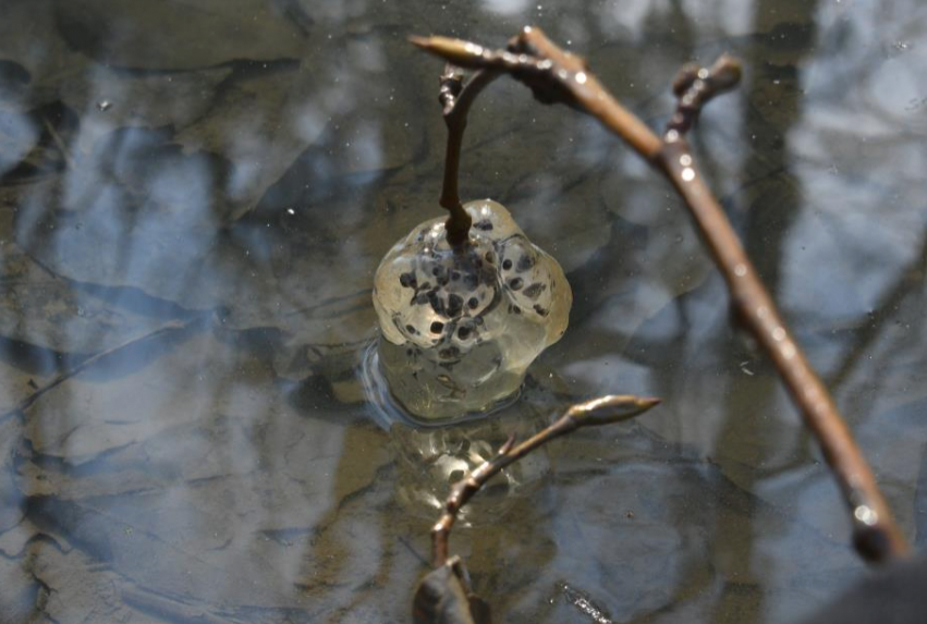
Amphibians
Egg masses of Northwestern Salamander found at same inland pool as previous
years
Molluscs
Freshwater snails in a recently dried pool area</blockquote>
Page 4 of 11
Arthropods
Spider (many were running quickly in sandy areas, then would abruptly stop)
Beetle (Opisthius richardsoni, previously identified on iNaturalist)
Birds
Birds have been entered on eBird at hotspot as follows:
https://ebird.org/canada/hotspot/L844938 <blockquote>
o Canada Goose 525 (4 fly over near start, 21 loafing in calm bay btw ER and
northern accreting island; 500 flying over from Chilliwack area towards Stave
Lake late in afternoon)
o Trumpeter Swan 43 (flying over in groups of 4 to 15 and loafing in calm bay
btw ER and northern accreting islands; more seen feeding on Nicomen island
farmers’ fields, but these not included in count)
o American Wigeon 65 (15 loafing on log in calm bay btw ER and northern
accreting islands; 50 fly over in one flock
o Mallard 20 flying over in one flock
o Common Merganser 13 both M & F (feeding in river in different channels in
small groups from 2 to 5
o Glaucous-winged Gull 5 (flying over as individuals)
o Double-crested Cormorant 4 (two perched on log in river and 2 flying over)
o Anna’s Hummingbird 1
o Bald Eagle 5 (2 immatures, 1 adult flew over, 2 adults perched in nest tree
below nest and one eating a duck seen through spotting scope pulling out
feathers)
o Red-tailed Hawk 1 flying hunting and perched in large cottonwood
o Northern Flicker 1 perched in tree
o Peregrine Falcon flying over hunting
o American Crow 5 flying over
o American Robin 4 (in vegetation, feeding)</blockquote>
Photos follow:
Page 5 of 11
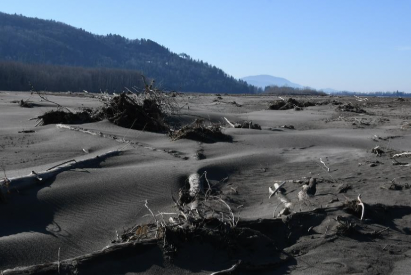 Deposits of sand and woody debris, looking downriver, Sumas Mtn distant horizon
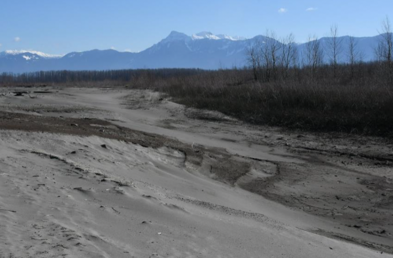 Deposits of sediments, looking upriver, Mt Cheam in distance
Page 6 of 11
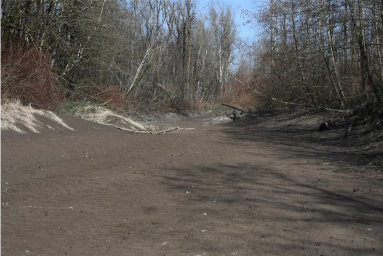 This inner swale was mainly gravel, now filled with sand-silt-clay deposits
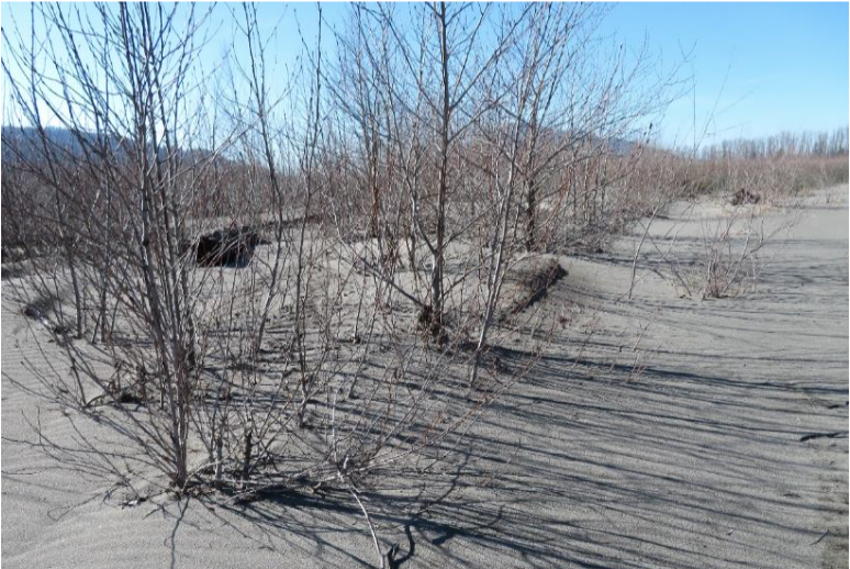 Sand deposited around trunks of young cottonwood
Page 7 of 11
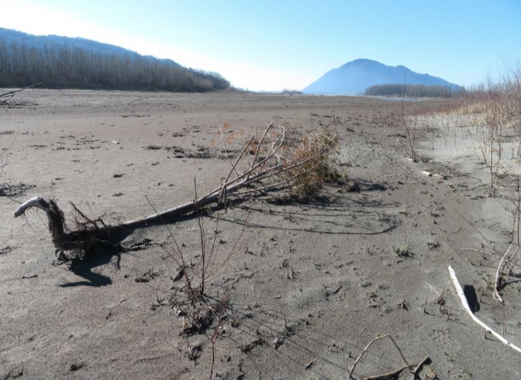 Small conifer tree; tiny pieces of broken conifer branches amongst organic materials scattered across the drying surfaces; Sumas Mtn in distance
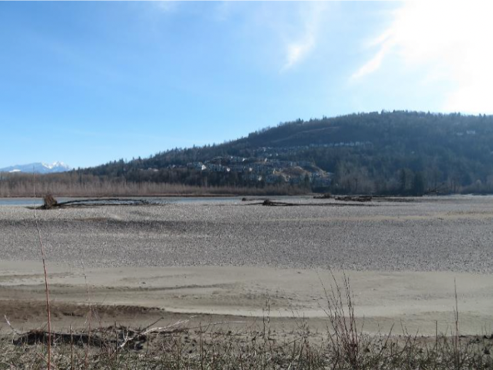
Gravel bar forming beyond the south facing shoreline of the islands; power of the
November floods shows with the many flood-erosion casualty trees resting on the
gravel bar; distant view is housing development on Chilliwack Mountain
Page 8 of 11
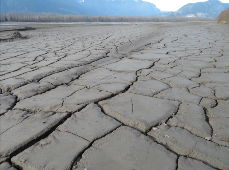
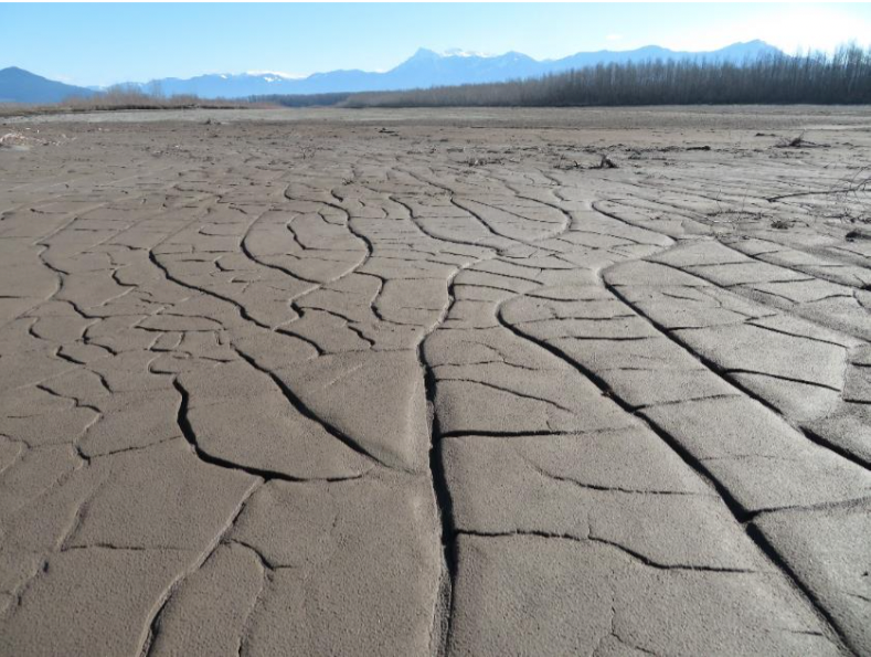 Two photos showing deposited sediments, forming “Mud Cracks” when drying
Page 9 of 11
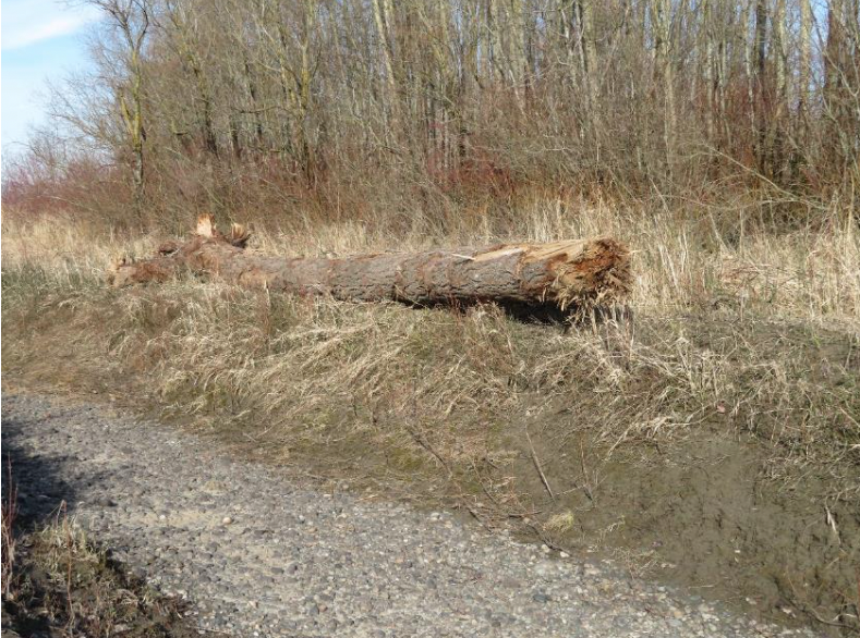
 Two photos show erosion-casualty battered Douglas fir
Page 10 of 11
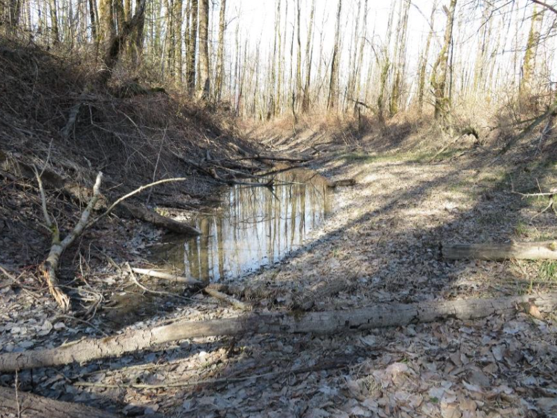 Pool in inner swale with Northwestern Salamander eggs
Page 11 of 11
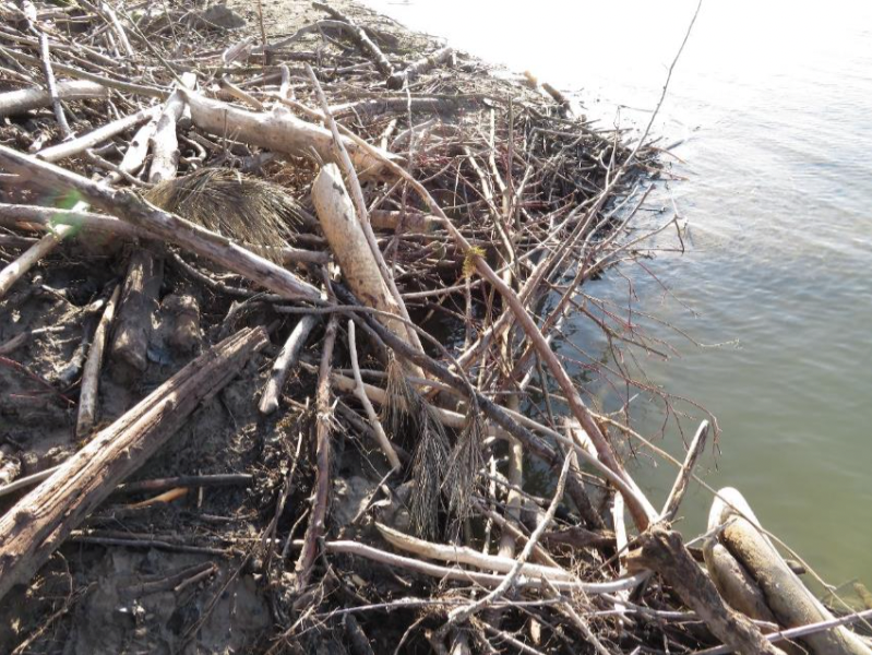 Entrance to bank style beaver lodge decorated with two short Ponderosa Pine branches
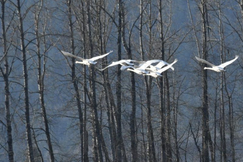 Trumpeter Swans that loaf in quiet back channel of islands and also feed on Nicomen Island farmers’ fields