News/Reports
Thinking like a dynamic mosaic: Towards a strategy for conserving northern Garry oak ecosystems * part 1
from
Menziesia: Newsletter of the NPSBC Native Plant Society of British Columbia 7 (1): 8 – 11.
Thinking like a dynamic mosaic:
Towards a strategy for conserving northern Garry oak ecosystems * part 1
Gordon Brent Ingram Tuesday * October 16, 2001 * The Richmond Natural History 4 Thinking like a dynamic mosaic:
Conservation planning for the northern Garry oak landscapes in BC
side stream environmental design
Over the last century and a half, most ecosystems with Garry oak (Quercus garryana) have been degraded or destroyed from agriculture and urbanization. Fire suppression has allowed oak groves to be overgrown by Douglas fir. Invasive species, particularly Scotch broom, have destroyed populations of herbaceous species. Garry oak ecosystems exist in some of the drier parts of the North American West Coast from Savary Island, near Powell River, to the mountains of Southern California. Some of the largest and oldest specimens of Garry oak trees are at its northern margins. Today, all of the Garry oak ecosystems in BC, along with more than one hundred associated plant and animal species, are at risk and warrant a comprehensive conservation plan.
In this article, I explore the idea of a shifting landscape mosaic as a framework to understand these ecosystems. In the trough between the mountains on the West Coast and the Coast Range, there are patches with low levels of rainfall. Here, mild winters and summer droughts, with cool temperatures, have created a home for a curious assortment of species often on the margins of their ranges. This poorly understood ecosystem type is one of the most biologically, in deed floristically, rich in Canada and probably has more species at risk than in any other part of the country. Understanding the dynamic processes that have created landscapes of Garry oak, grassland, and Douglas fir, with a wide range of tree ages and successional phases, is key to developing effective initiatives to plan, design, manage and restore local biodiversity. Without a comprehensive and adaptive network of protected areas (with the involvement of numerous stakeholders, jurisdictions and agencies), scores of vascular plants and bryophytes, not to mention some invertebrates, birds and mammals, could disappear from Canada and move closer to extinction.
Every landscape embodies some kind of change; some shifting mosaic of different habitats. But the dramatic (and beautiful) dynamics of relatively high contrast and porous ecological edges between high Douglas firs, lower oak and grassland, along with the mild winters with standing water, have nurtured an exceptional number of niches and level of plant diversity. With so many species that warrant mapping and protection of their critical habitats, how can we organize our efforts across a diverse region of shores, south-facing mountain slopes, larger and smaller Gulf Islands, and to two, still vulnerable, areas in the Lower Mainland? The title of this discussion, “thinking like a dynamic mosaic,” is in homage to Aldo Leopold’s celebrated essay from the 1930s on the destruction of native vegetation in northern New Mexico, ‘Thinking like a mountain’. While the loss of vegetation and soil in the southern Rockies was dramatic, the disappearance of many plant species due to heavy browsing from a population explosion of deer, because of extermination of the wolf, was poorly understood.
The best remaining places to help us begin to understand the forces that sustain the biodiversity of Garry oak ecosystems are remaining pocket wilderness areas such as the southwest face of Mt. Maxwell on Salt Spring Island. Twenty years ago, my M.Sc. thesis was on management and restoration of clusters of ecological reserves in BC including the Gulf Islands. Since then, I have learned much more from fieldwork and have organized field trips. At the end of November 2002, a consortium of government agencies and nongovernmental organizations finally acquired much of this dynamic mosaic. But the work of protecting a range of rare and vulnerable species has just begun. While this landscape is in great need of restoration, especially for the re-introduction of fire and removal of Scotch broom and the few remaining sheep, Mt. Maxwell is one of the best baselines left for understanding Garry oak ecosystems.
There remain another fifteen to twenty pocket wilderness areas of 1,000 to 3,000 hectares that will soon either be protected or destroyed. Key dynamic mosaics that have yet to be protected include Nanoose, parts of Hornby Island, Skirt Mountain near Victoria, Reginald Hill on Salt Spring, Sutil Mountain on Galiano, and several parcels owned by the military around Victoria. Most of these areas harbour rare plant species and represent the best hopes for protecting the organisms most vulnerable to disappearance. And there are another over one hundred, larger fragments of Garry oak ecosystems, particularly around Victoria, the protection and linking of which may be crucial to the survival of some plants species. But even if
threats from development are removed, others, such as climate change, remain. In a world of unpredictability, how can we design networks of protected areas that are sufficiently secure and with populations large enough to maintain more vulnerable species indefinitely? How can we protect possibilities for disturbance for landscapes where shifts in biomass, from fire and weather fluctuations, may well have even enhanced the phytodiversity? Life histories and landscape ecology of plant species can tell us as much about how to design these protected areas as what we know about vertebrates and invertebrates. My approach to envisioning the space necessary to conserve these species is to embrace the chaos and anticipate change in ecosystems (that are particularly dynamic anyway). Questions remain about how to maintain more stable aspects of these landscapes, such as the old-growth. Much of the early heritage of modern ecosystem and conservation theory fixated on stability and singular notions of climax. The early biogeoclimatic mapping of conservation pioneers such as V. J. Kraijna barely recognized Garry oak ecosystems and dismissed them as disturbed areas eventually to be dominated by Douglas fir – if aboriginal presence and fire were somehow removed. Today, nearly all of us committed to viable biodiversity conservation try to respect these less predictable forces – when we understand them.
Garry oak ecosystems in BC
The white oaks are some of the 15 species of Quercus on the West Coast. In contrast to other North American oak species, this group evolved with summer drought. As the mountains of the west coast of North America rose, over the last 40 million years, rain shadows were formed. Oaks are confined to drier areas, just inland from the West Coast, until central and southern California. Garry oak occurs with or nearby Douglas fir and arbutus throughout much of its range. The co-evolution of these three trees is a key saga in plant evolution on the West Coast. South of Marin County, Garry oak is rare near the coast with only two localities in the Santa Cruz Mountains. On the east side of the Central Valley, Garry oak extends from the Cascades to the Sierra Nevada. There is an almost interrupted belt of Garry oak to the Tehachapis and one isolated tree recorded in Los Angeles County. In marked contrast to the centuries-old savannah trees at its northern margins, Garry oaks in southern California are little more than rounded shrubs on dry slopes between 2500 and 5000 feet elevation. Here, fire has a regular presence. Garry oak has the widest distribution of all of the West Coast oaks and quite possibly the widest range of plant forms. In virtually all of the southern two thirds of its range, Garry oak occurs with other native oaks – and hybridizes with a number of other Quercus species. The richness and plasticity of the gene pool may explain why this species has adapted so well to so many different conditions – though all with summer drought, mild winter and summer temperatures, and fire.
At the northern margin of its occurrences, Garry oak is confined to dry, southwest-facing slopes and flat, well-drained gravely sites. In BC, Garry oak is an island species only occurring on the mainland at some of the drier areas: on Sumas Mountain and at Yale. On the cusp of rainy parts of the coast, it is easy to see why the northern margins of Garry oak follow the northern Strait of Georgia: to the Comox Valley and Savary Island. However there are mysteries. Nineteenth century researchers described an isolated grove at the eastern end of Quatsino Sound on northern Vancouver Island, another rainshadow, and even a grove on the “plains” of Vancouver (perhaps not far from slopes above the main Musqueam villages). If there really were oaks in those locales, Garry oak ecosystems might again be key vegetation for much of south- western BC. Two sets of factors suggest that Garry oak ecosystems might expand in the future – if associated biodiversity were adequately protected. Climatic fluctuations continue and aboriginal land use and plant harvesting practices could be reasserted and adapted as modern agriculture.
Perhaps one of the best clues to the shifting nature of these ecosystems comes from pollen records. After the melting of the last ice cap, 11,000 to 9,000 BP, things warmed up quickly. There was rapid colonization by pioneer vegetation species such as Lodgepole pine (which today persists in some of the wettest and driest sites of these dynamic mosaics). Garry oak re-colonized from the south. Throughout the glacial period, there remained Garry oak populations in lower elevations of Oregon and California. Probable centres of Garry oak ecosystem biodiversity were low mountain ranges, that were not glaciated, with considerable environmental heterogeneity (and a diversity of selection factors): the Klamath Mountains in south-western Oregon and the Trinity Range in far north-western California. By 7500 BP, Garry oak was re-established and thriving in a warmer climate than today’s. It probably took some of southerly species additional hundreds and thousands of years to colonize this far north. But the movement was not all from south to north. Grasses and forbs quickly re-established in the interior of BC and in
Alberta and these were soon colonizing the drier parts of the coast. So the Strait of Georgia was not just an impoverished copy of less glaciated, “Oregonia” but a rather a unique and queer combination of species that may have never evolved together before. How Garry oak got back to the islands is an interesting question. Oaks reproduce by acorns, which are difficult to transport by wildlife, and Garry oak also reproduces by clones (that can not spread across natural barriers). Much of the dispersal that created current populations this far north could have involved some larger birds and mammals — and human beings. Soon there was a cooling phase between 7040 and 5750 years BP and Douglas fir and Western hemlock increased. Curiously, the presence of Garry oak does not appear to decline in the 5750 – 3800 years BP period. Some new force intensified years 3800 – 1050 BP. Oak appear to have increased as the climate cooled – and as fire, whether natural or aboriginal, increased.
Northern Garry oak ecosystems as cultural landscapes
The landscape changes that were figured /in the pollen analyses suggest the emergence of a culture of heavy use of Garry oak meadows along with burning. We can assume that people were in the Georgia Basin area since the last icecap began receding – with a possibility of some links to earlier marine-based cultures from around the North Pacific. Subsequently, cultural developments and perhaps other human migrations transformed ecosystems around the Strait of Georgia. Salish food gathering had a particular emphasis on root crops, such as camas (Camassia spp.) and wild onions, Allium spp., and a score of other species. All of these root foods tend to thrive with the mild winters and can survive both summer droughts and some burning. Salish tuber culture has some similarities to many other island and coastal societies around the Pacific Rim. And peoples from the interior of North America and from California had developed techniques for careful manipulation of the landscape through fire. Coast Salish cultures may well have represented a cultural fusion where root crop digging and burning cultures met. In this shifting landscape, a range of plant species became established in the fertile niches created by the numerous edges and the nutrient availability from the digging and burning. And just as people and trade goods moved between north and south and between west and east, knowledge of burning was accumulated and deepened. Even as traditional communities were forced on to tiny Indian Reserves, Salish elders continued to try to assert their values, their cultural responsibility, to burn traditional lands until as late as 1960. I watched this as a child by Chief Christopher Paul on the land owned by my family that was claimed by his First Nation. Accepting the necessity of aboriginal burning was the compromise between the families in a tangle of questionable treaty and bad surveying. Unfortunately, the Central Saanich Fire Department put a stop to thousands of years of this land management in the early 1960s.
The structure of remaining Garry oak ecosystems
Garry oak ecosystems range in structure from savannahs to woodlands. Today, the latter too often is being overgrown with Douglas fir to the point of shading out many species. Three strata relate to dominant vegetation forms and biomass: herbaceous, shrub, and canopy trees. There are few native vines except for the one honeysuckle and rare populations of poison oak (a co-dominant to the south but a species vulnerable to burning). With cool Mediterranean-like ecosystems, there are two additional layers that are poorly understood. Under the ground are the roots of many forbs and other herbaceous plants that survive the summer drought (and cool fires). In the upper canopies are such groups as lichens.
Ecosystems that are temperate and with summer drought are often termed “fire-climax” because some regular combustion (especially in particularly dry years) is inevitable. These ecosystems, from south- eastern Vancouver Island to southern California, from Chile to Australia to the extreme south of South Africa, and from to southern Europe to Iran, have a number of similarities. First, most species can cope with a summer drought (and conversely have growth periods that extend into the warmer portions of winter) and subsequent water deficit. For some species, the summer drought is time of annual dormancy. And in the winter, a group of herbs and forbs, on warmer south-facing slopes, continue to grow. And northern Garry oak ecosystems are diverse because although they have far few California species, they have others distributions centred to the northeast in Canada. In Canada, we have not had much of a frame of reference for Mediterranean-like ecosystems. For comparison with European ecosystems, Garry oak landscapes have more functional similarities to central and southern France rather than Britain or the Atlantic coast.
Most species in a Garry oak ecosystem has some adaptations coping with drought. Oaks and arbutus have leathery leaves that minimize water loss. Douglas fir is often the most successful conifer in areas of mild winters and summer drought from northern California to British Columbia. But in years of pronounced water deficit, many young firs ‘get fried’ and die of stress. Many herbaceous species are perennial with root systems that allow them to survive the warm and dry months. A second characteristic of temperature summer drought ecosystems (with mild winters) is fire-resistant trees that tend to dominate. And it is with this exceptionally small number of tree species that much of the biomass of the ecosystem (and key habitat) is maintained. Whereas California has scores of such fire-resistant tree species, the major species this far north are the older Garry oaks and Douglas fir (protected by their very thick bark often more than 3 cm). A third characteristic of these cool fire ecosystems is also because of these fire-resistant trees in combination with lower temperatures and low rainfall that slows the breakdown of wood. When these trees die, they tend to stay standing as snags — often for decades. Old-growth Garry oak and Douglas fir mosaics provide an exceptional set of niches and habitats for a host of species associated with both the grazing (live plant) and the detritus (dead) food webs.
A fourth characteristic of these mild, summer drought ecosystems is the role of fire in periodic release and redistribution of nutrients in short supply. The problem with a lot of standing wood is that nutrients get locked away – unless there is a disturbance such as fire. Thus, these ecosystems are often remarkably productive because of this relatively rapid (for this latitude) cycling of nutrients and the ‘spottiness’ of redistribution. These processes diversify and shift these mosaics, spatially. Spotty burns from `cool’ fires (where there is not much un-insulated fuel to burn,) in turn, contribute to diversity of herbs, shrubs, trees, insects, and small vertebrates. There is a link between germination of some plants and nutrient release in the rains after fire. In part two of thinking like a dynamic mosaic, in the next issue, I will describe some of the most vulnerable of the plant species in northern Garry oak ecosystems and how we can begin to consider how to guarantee niches and enough (shifting) places for them.
Brent teaches in the University of Victoria Restoration of Natural Systems Program and is the Co-chair of the Conservation Planning & Site Protection Recovery Action Group of the Garry Oak Ecosystems Recovery Team. This scientific advisory group is open to new members. This article reflects Brent’s own research and perspectives only and does not represent any organization.
email: side_stream_environmental_design@telus.net.
captions for Thinking Like a Dynamic Mosaic pt. 1
Click on the images of the gallery to get the pictures and the captions:
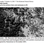
Part of a dynamic mosaic – Mt. Maxwell, Salt Spring Island, June 1975. Part of this area is in Mt. Maxwell Provincial Park and Ecological Reserve with another crucial private land until it was acquired by Naturetrust in November 2001.
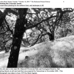
This old oak is very near Mt. Maxwell Provincial Park and Ecological Reserve, Salt Spring Island, on private land that was acquired by Naturetrust in November 2001. This photograph was taken in June 1979 by Brent Ingram.
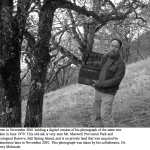
Brent in November 2001 holding a digital version of his photograph of the same tree taken in June 1979. This old oak is very near Mt. Maxwell Provincial Park and Ecological Reserve, Salt Spring Island, and is on private land that was acquired by Naturetrust later in November 2001. This photograph was taken by his collaborator, Dr. Terry McIntosh.
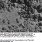
This is the same area on Mt. Maxwell, Salt Spring Island, around where the old oak photographed in 1979 and 2001 and that was finally protected in November 2001. This scene of a dynamic mosaic illustrates tremendous horizontal and vertical landscape diversity. In the lower left is Garry oak savannah and grassland. Across the upper half of the scene is old-growth Douglas fir forest. In the lower right is younger Garry oak woodland where the canopy is dominated by this species. There are roughly ten dead Douglas fir tree, snags, in this scene. These trees appear to have died in recent years probably from water deficit stress.
Gordon Brent Ingram Tuesday * October 16, 2001 * The Richmond Natural History 9 Thinking like a dynamic mosaic:
Conservation planning for the northern Garry oak landscapes in BC
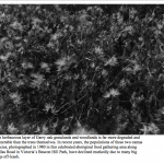
The herbaceous layer of Garry oak grasslands and woodlands is far more degraded and vulnerable than the trees themselves. In recent years, the populations of these two camas species, photographed in 1980 in this celebrated aboriginal food gathering area along Dallas Road in Victoria’s Beacon Hill Park, have declined markedly due to many big dogs off-leash.
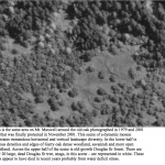
This is the same area on Mt. Maxwell around the old oak photographed in 1979 and 2001 and that was finally protected in November 2001. This scene of a dynamic mosaic illustrates tremendous horizontal and vertical landscape diversity. In the lower half is various densities and edges of Garry oak dense woodland, savannah and more open woodland. Across the upper half of the scene is old-growth Douglas fir forest. There are over 20 large, dead Douglas fir tree, snags, in this scene – are represented in white. These trees appear to have died in recent years probably from water deficit stress.
Click on the following for images of the appendix.
Gordon Brent Ingram Tuesday * October 16, 2001 * The Richmond Natural History 4 Thinking like a dynamic mosaic:
Conservation planning for the northern Garry oak landscapes in BC
side stream environmental design.

