|
Towards Integrated Management solutions: The Itcha-Ilgachuz Caribou Project Radio-Telemetry Year 3 progress report
(1995-98)
By James A. Young and Kerra L. Shaw, November 1998
TABLE OF CONTENTS
SUMMARY
ACKNOWLEDGMENTS
1.0 INTRODUCTION
2.0 OBJECTIVES
3.0 STUDY AREA
4.0 METHODS
5.0 RESULTS
5.1 Snow Characteristics
5.2 Habitat Selection with Elevational Changes
5.3 Habitat Selection and Slope
5.4 Habitat Selection and Aspect
5.5 Biogeoclimatic Zone Use
5.6 Caribou Habitat Type Use
5.7 Forest Cover Type Use
5.8 Habitat Selection and Stand Age
5.9 Habitat Use and Stand Crown Closure
5.10 Park and CCLUP Sub-Unit Use
5.11 Home Ranges
6.0 DISCUSSION
6.1 Habitat Use and Seasonal Movements
6.2 Future Directions
7.0 LITERATURE CITED
LIST OF TABLES
Table 1: Percentage of forest-dwelling radio-collared caribou locations in each caribou habitat type by season in 1995-96 for the Itcha-Ilgachuz Mountains herd
Table 2: Percentage of forest-dwelling radio-collared caribou locations in each caribou habitat type by season in 1996-97 for the Itcha-Ilgachuz Mountains herd
Table 3: Percentage of forest-dwelling radio-collared caribou locations in each caribou habitat type by season in 1997-98 for the Itcha-Ilgachuz Mountains herd
Table 4: Percentage of forest-dwelling radio-collared caribou locations in each caribou habitat type by season in 1995-98 for the Itcha-Ilgachuz Mountains herd
Table 5: Percentage of forest-dwelling radio-collared caribou locations in each forest cover type by season in 1995-98 for the Itcha-Ilgachuz Mountains herd
Table 6: Percentage of forest-dwelling radio-collared caribou locations in each forest type by season in 1995-98 for the Rainbow Mountains herd
Table 7: Percentage of winter alpine-dwelling and winter forest-dwelling radio-collared caribou in each CCLUP sub-unit by season in 1995-98
LIST OF FIGURES
Figure 1: CCLUP Sub-Units of the Study Area
Figure 2: Biogeoclimatic Zones of the Study Area
Figure 3: Percentage of radio-collared caribou seen from the aircraft when relocated by radio-telemetry
Figure 4: Radio-collared female caribou locations in the Itcha-Ilgachuz-Rainbow area between May and October
Figure 5: Radio-collared female caribou locations in the Itcha-Ilgachuz-Rainbow area between November 1995 and April 1996
Figure 6: Radio-collared female caribou locations in the Itcha-Ilgachuz-Rainbow area between November 1996 and April 1997
Figure 7: Radio-collared female caribou locations in the Itcha-Ilgachuz-Rainbow area between November 1997 and April 1998
Figure 8: Snow characteristics at Puntzi Mtn. snow station (940 m, 28 years of record)
Figure 9: Snow characteristics at Nazko snow station (1070 m, 21 years of record)
Figure 10: Percentage of winter forest-dwelling radio-collared caribou locations in each 200 meter elevational band by month for the Itcha-Ilgachuz Mountains herd
Figure 11: Percentage of winter forest-dwelling radio-collared caribou locations in each 200 meter elevational band by season for the Itcha-Ilgachuz Mountains herd
Figure 12: Mean elevation (+/- 1 standard deviation) of radio-collared caribou locations by week. The Forest-Dwelling class includes data from both the Itcha-Ilgachuz and Rainbow Mountains herds.
Figure 13: Percentage of winter forest-dwelling radio-collared caribou locations in each 200 meter elevational band by month for the Rainbow Mountains herd
Figure 14: Percentage of winter forest-dwelling radio-collared caribou locations in each 200 meter elevational band by season for the Rainbow Mountains herd
Figure 15: Percentage of winter alpine-dwelling radio-collared caribou locations in each 200 meter elevational band by season
Figure 16: Percentage of winter forest-dwelling radio-collared caribou locations in each slope category by season for the Itcha-Ilgachuz Mountains herd
Figure 17: Percentage of winter forest-dwelling radio-collared caribou locations in each slope category by season for the Rainbow Mountains herd
Figure 18: Percentage of winter alpine-dwelling radio-collared caribou locations in each slope category by season
Figure 19: Percentage of winter forest-dwelling radio-collared caribou locations in each aspect by season for the Itcha-Ilgachuz Mountains herd
Figure 20: Percentage of winter forest-dwelling radio-collared caribou locations in each aspect by season for the Rainbow Mountains herd
Figure 21: Percentage of winter alpine-dwelling radio-collared caribou locations in each aspect by season
Figure 22: Percentage of winter forest-dwelling radio-collared caribou in each biogeoclimatic sub-zone by month for the Itcha-Ilgachuz Mountains herd
Figure 23: Percentage of winter forest-dwelling radio-collared caribou in each biogeoclimatic sub-zone by season for the Itcha-Ilgachuz herd
Figure 24: Percentage of winter forest-dwelling radio-collared caribou in each biogeoclimatic sub-zone by month for the Rainbow Mountains herd
Figure 25: Percentage of winter forest-dwelling radio-collared caribou in each biogeoclimatic sub-zone by season for the Rainbow Mountains herd
Figure 26: Percentage of winter alpine-dwelling radio-collared caribou in each biogeoclimatic sub-zone by month
Figure 27: Percentage of winter alpine-dwelling radio-collared caribou in each biogeoclimatic sub-zone by season
Figure 28: Percentage of forest-dwelling radio-collared caribou locations in each forest cover age class by month for the Itcha-Ilgachuz Mountains herd
Figure 29: Percentage of forest-dwelling radio-collared caribou locations in each forest cover age class by season for the Itcha-Ilgachuz Mountains herd
Figure 30: Percentage of forest-dwelling radio-collared caribou locations in each forest cover age class by month for the Rainbow Mountains herd
Figure 31: Percentage of forest-dwelling radio-collared caribou locations in each forest cover age class by season for the Rainbow Mountains herd
Figure 32: Percentage of forest-dwelling radio-collared caribou locations in each crown closure class by month for the Itcha-Ilgachuz Mountains herd
Figure 33: Percentage of forest-dwelling radio-collared caribou locations in each crown closure class by season for the Itcha-Ilgachuz Mountains herd
Figure 34: Percentage of forest-dwelling radio-collared caribou locations in each crown closure class by month for the Rainbow Mountains herd
Figure 35: Percentage of forest-dwelling radio-collared caribou locations in each crown closure class by season for the Rainbow Mountains herd
LIST OF APPENDICES
Appendix 1: Caribou Habitat Types in the Itcha-Ilgachuz Study Area
Appendix 2: Home Range Maps
Appendix 3: Combined Home Range Map 79
Appendix 4: Lifetime and Annual Home Ranges of 34 Radio-collared Caribou in 1995-98 81
1.0 INTRODUCTION
The Itcha-Ilgachuz Mountains caribou (Rangifer tarandus caribou) herd appears to be stable and consists of approximately 1700 caribou (late fall estimate). The Rainbow Mountains caribou herd is stable, and consists of approximately 125 caribou. Because the caribou from the Itcha-Ilgachuz herd and the Rainbow herd sometimes share a common winter range, they are considered to be two herds of the same population (Hatler, 1987). These animals summer primarily in alpine and subalpine habitat in the Itcha, Ilgachuz, and Rainbow Mountains. Their winter range has shown to vary in different years. The caribou that calve in the Rainbow Range appear to winter either in the alpine habitats of the Rainbow or Ilgachuz Mountains or in low elevation pine stands along the Dean River in the vicinity of Anahim Lake. The caribou that calve in the Itcha-Ilgachuz Mountains appear to winter either in the alpine habitats of the Itcha and Ilgachuz Mountains or in mid-elevation pine stands generally to the north, east, and south of the Itcha Mountains.
Two components of caribou habitat are considered essential for ensuring viable caribou populations: summer calving habitat and winter habitat. During calving, caribou within this population require undisturbed mountainous terrain where they can distance themselves from other prey and predators. During winter, caribou require large areas of suitable habitat that contain adequate available forage and security cover. Most of the winter range habitat for the Itcha-Ilgachuz caribou is located outside of protected areas and will be subject to logging development. Most of the population summers in high elevation areas that are protected within parks (BC Government 1996).
The Cariboo-Chilcotin Land Use Plan (CCLUP) requires the development of a caribou strategy for the Itcha-Ilgachuz caribou herd by June 30, 2000. The major requirements are the initiation of a research and inventory program that will lead to the development of an integrated management approach. More specifically, the CCLUP identifies timber targets for the polygons that Itcha-Ilgachuz caribou inhabit by defining areas of “no harvest” and “modified harvest”. Although an Interim Strategy was presented in July of 1996, additional work must be undertaken to refine the options that were proposed at that time to ensure the most appropriate stands are designated in the “no harvest” or “modified harvest” categories.
2.0 OBJECTIVES
This progress report documents the results of three years of monitoring radio-collared caribou within the Itcha-Ilgachuz and Rainbow Mountains.
Specific objectives of this program are:
To determine seasonal landscape level habitat selection by caribou by comparing attributes of caribou radio relocations to what is available within the study area.
To assess caribou habitat use at the landscape level in relation to recent logging in the area, adaptive management prescriptions and bench-mark habitat use information collected in the mid-1980’s.
To develop and test a caribou habitat suitability model utilising radio location information in conjunction with 1:50 000 terrestrial ecosystem mapping.
To identify priority areas for “no harvest” and “modified harvest” designation as outlined by the Cariboo-Chilcotin Land Use Plan.
3.0 STUDY AREA
The Itcha, Ilgachuz and Rainbow Mountain ranges are located in the western part of central British Columbia within the Western Chilcotin Uplands Ecosection. The area is divided into several sub-units within the Cariboo-Chilcotin Land Use Plan (Figure 1). The alpine area of these old volcanic ranges is gentle and rolling and reaches elevations close to 2500 m. The steeper and rockier Ilgachuz Range is surrounded and separated from the Itchas by a plateau composed of pine forests and meadows. The Rainbow Range is separated from the Ilgachuz Range by the Dean River which flows north and then west into Dean Channel.
The Very Dry, Cold Sub-Boreal Pine-Spruce (SBPSxc) sub-zone, the Moist, Cold Sub-Boreal Pine-Spruce (SBPSmc) sub-zone, and the Dry, Cold Sub-Boreal Pine-Spruce (SBPSdc) subzone make up the lower elevations or valley bottoms of this plateau (<1200 m), while the predominate zone in the study area is the Very Dry, Very Cold Central Montane Spruce sub-zone (MSxv) located above the SBPS at mid-elevations (Figure 2). A narrow band of the Engelmann Spruce Subalpine Fir subzone (ESSF; >1650 m) exists at higher elevations and all three ranges contain an Alpine Tundra (AT) zone above the ESSF (>1825 m). These elevational breaks are only estimates, as the actual values differ between each range with snow pack, which affects the width of the ESSF zone (R. Coupé, Ministry of Forests, pers. comm.).
The dominant tree species in the SBPS and the MS zones is lodgepole pine (Pinus contorta). Interior spruce (Picea glauca X engelmannii) is associated with wetlands and mixed stands with pine. Soopolallie (Sheperdia canadensis) is the dominant shrub in the zones with a herb layer consisting of mosses, terrestrial lichens (Cladina spp., Cladonia spp., Stereocaulon spp., Peltigera spp.), and kinnikinnick (Arctostaphylos uva-ursi). Fescue lichen meadows are present in areas of cold air ponding and wet sedge fens and shrub-carrs occur along drainages and in areas where the water table is near the surface. Festuca altaica is the dominant grass in the meadows, and shrub birch (Betula glandulosa) and willows (Salix spp.) are associated with shrub-carrs.
The ESSF contains stands of lodgepole pine, interior spruce, and subalpine fir (Abies lasiocarpa). Bryoria spp. is the dominant arboreal lichen. The AT zone contains communities of terrestrial lichens, grasses, and dwarf scrub (Cassiope spp., Phyllodoce spp., Empetrum nigrum, Arctostaphylos uva-ursi, Vaccinium spp., Dryas spp., Salix spp., Betula glandulosa; Cichowski 1993).
Figure 1: CCLUP Sub-Units of the Study Area
Figure 2: Biogeoclimatic Zones of the Study Area
4.0 METHODS
Adult female caribou were captured by net-gunning them from a helicopter in open habitats throughout the study area. In October and November of 1995, twenty animals were captured and fitted with radio collars. All of these animals moved to lower elevation forests during the winter. In February of 1996, eight caribou wintering in alpine areas were captured and fitted with radio collars, 5 more were recruited in October 1996, and the last caribou was collared in February 1998. Once captured, all caribou were restrained by leg hobbles, blind folded, ear tagged, and fitted with conventional mortality-motion sensitive radio collars. During the years of the study, there have been seven mortalities and one failed collar, leaving us with twenty-six surviving caribou as of May 1998.
Radio-collared caribou were relocated two to four times per month by a fixed wing aircraft. Universal Transverse Mercator (UTM) co-ordinates, location, time, visual contact, and comments relating to group size and habitat use were recorded with each animal’s relocation. The UTM co-ordinates were established with a Global Positioning System (GPS) in the aircraft. The UTM co-ordinates generated were then plotted on 1:50,000 topographic maps. If the points obtained were not consistent with where the observer viewed the animals, they were adjusted on the map and the correct UTMs entered into the data base.
In the past, topographic features (slope, aspect, and elevation) were estimated when the locations were plotted on the above noted 1:50,000 scale topographic maps. Forest cover and caribou habitat attributes were obtained from plotting locations onto B.C. Forest Service forest cover maps and caribou habitat maps both at a scale of 1:50,000. This year, UTM locations were entered into Unix ArcInfo 7.1.2 GIS which generated all the attributes given in this report from the most recent coverages (except for the caribou habitat information which has not yet been digitised). As a result of this data being generated in a different way, there may be some small discrepancies in habitat use from past reports.
The accuracy of the data point UTMs gathered from the caribou relocation flights was estimated by placing collars in open and closed sites to represent visual and non-visual relocations of caribou, and located aerially by the contractor who usually performs these flights. Potential error may cause the computer generated data from the given UTMs to be in a different or bordering category from the actual one the caribou was present in when relocated. This error may average out when as many data points as we have in this report are being analysed. One way employed to prevent small habitats from being under-represented was by recording in what habitat the caribou was visually observed during telemetry flights. When an animal was located and sighted, the vegetation it was observed in was recorded (e.g. pine forest, clear-cut, meadow). The computer generated attributes were compared to the observer recorded comments and changes made if necessary to keep the results as consistent to the visual observations as possible.
The percentage of relocations in each slope and aspect category was used to calculate different patterns of use in each season. Computer coverages gave all locations numerical values for slope and aspect, which were then divided into more comprehensive categories for graphing. In the past there had been a category of “flat” in the aspect section, however this year it was removed as the computer, using the National Topographic System (NTS), could generate aspects for all locations.
Winter divisions used were those established by Cichowski (1993). Early winter was from December until mid-January, mid-winter was from mid-January to mid-March, late winter was from mid-March until the end of April. Winter itself was December to March (inclusive). The other divisions were determined by comparing habitat use patterns between months: spring was considered May, summer was June until the end of August, early fall was September and October, and late fall was November. In an attempt to illustrate changes in habitat use patterns, results were displayed by season, month, and in one case, by week.
The average elevation for each week (+/- 1 standard deviation) was calculated along with the percentage of animal locations in each 200 m elevational band. Rough demarcations between biogeoclimatic zones were placed on the graph summarising this information. The percentage of collared animals visually detected when relocated was also determined for each season.
Snow depth and density information was obtained from observations made at two permanent snow stations, Puntzi Mountain and Nazko, monitored by B.C. Environment Water Management staff from Williams Lake.
Forest cover information was grouped according to the dominant tree species, the site class, and the age class as outlined by Cichowski (1993). Low sites were lower quality than poor sites that were in turn lower quality than medium sites. These categories were easily converted from numerical values given by the computer generated data. Age classes 1-4 (0-80 years) were grouped as immature stands and age classes 5-9 (80-251+ years) were considered mature sites. The use of different stands in each season and total winter was represented as a percentage. Similarly, comparisons of crown closure use patterns were also made in each month and season. There were a few relocation points that had partial forest cover data, but lacked crown closure information because the map sheets have not been updated since the 1970’s (G. Lee, Ministry of Forest, pers. comm.). Therefore these points were excluded from the crown closure section, although they were included in other sections when they were associated with complete information.
The caribou habitat polygons (individually labelled map units) were grouped according to the abundance of terrestrial lichens (based on percentage ground coverage) and the types delineated by Cichowski (1993; Appendix 1). The use of each grouping for the total winter and each season was determined. Individual habitat units are described in more detail in the legend of the caribou habitat maps (B.C. Ministry of Forests, 1987; Cichowski, 1993). In the SBPSmc and MSxv biogeoclimatic sub-zones, Dry Lichen (DL) sites contained the most terrestrial lichen followed be Lichen Moss (LM). Very little terrestrial lichen was found in Moss (M) or Seepage Forest (SF) sites. Arboreal lichens were present in all forested habitat types but were most common in moister types. Wetlands (W) and Non-forested Wetlands (NW) were wet and contained mostly grasses, sedges, and shrubs. Fescue-Lichen (FL) meadows were dry open areas containing grasses and terrestrial lichens. In the SBPSxc subzone, Dry Lichen and Kinnikinnick (K) sites contained the most terrestrial lichens while the rest of the sites contained very little (Cichowski 1993).
5.0 RESULTS
A total of 2351 caribou relocation points were obtained from the first three years of the project, from October 1995 until the end of May 1998, and are mapped in Figures 4-7. Five hundred and twenty-four caribou locations were collected in the first 8 months of monitoring (1995-96), 865 in the following 12 months (1996-97), and 962 in the last 12 months (1997-98). Summaries from past years can be found in this report and previous reports (Young and Loveridge, 1996; Young, Shaw, and Loveridge, 1998).
Eighty-two percent of the radio-collared caribou were seen during telemetry flights. The percentage of radio-collared caribou visually observed from the aircraft while telemetry locations were obtained differed with season; decreasing from a high of 92% in the early winter to a low of 67% in late winter/early spring (Figure 3). These results could be due to varying habitat choices at different times of the year, the corresponding visibility in these habitats, as well as changing weather conditions during the telemetry flights. The average error for relocation points was estimated at 157m, with a standard deviation of 68 meters (95% confidence interval of 23.7-290.3).
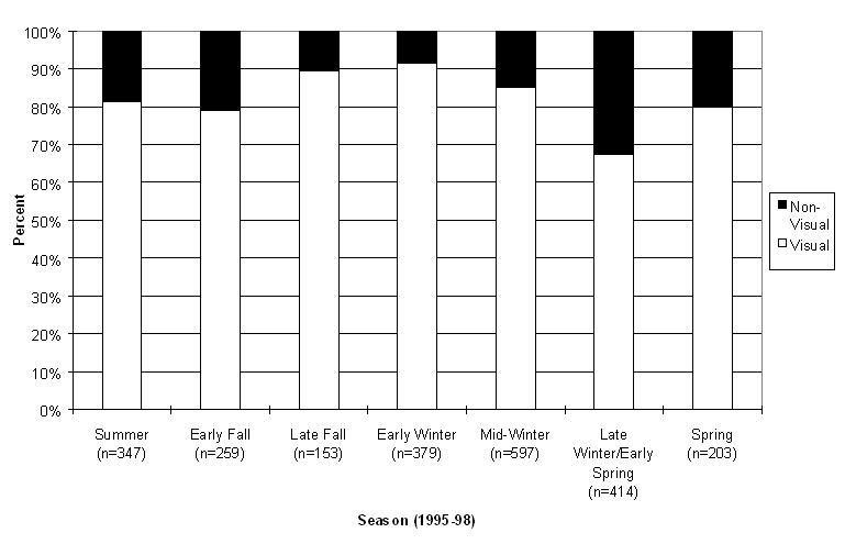
Figure 3: Percentage of radio-collared caribou seen from the aircraft when relocated by radio-telemetry
Figure 4: Radio-collared female caribou locations in the Itcha-Ilgachuz-Rainbow area between May and October
Figure 5: Radio-collared female caribou locations in the Itcha-Ilgachuz-Rainbow area between November 1995 and April 1996
Figure 6: Radio-collared female caribou locations in the Itcha-Ilgachuz-Rainbow area between November 1996 and April 1997
Figure 7: Radio-collared female caribou locations in the Itcha-Ilgachuz-Rainbow area between November 1997 and April 1998
As radio-collared caribou displayed three different habitat use strategies during winter, data was summarised separately for each general pattern of use for the portion of the year where there were obvious differences in use. Some of the caribou chose to winter in the upper ESSF and AT zones (winter alpine-dwelling), primarily on windswept ridges, whereas the majority of animals wintered at lower elevations within forested habitats (winter forest-dwelling). As the low elevation or forest-dwelling animals wintered in two separate and distinct areas, habitat use information was then divided and summarised by herd. The alpine-dwelling caribou were separated from the forest-dwelling caribou for the months of February-May (mid-winter, late winter/early spring, and spring). For the rest of each year when they showed similar habitat use patterns, they were grouped with other radio-collared caribou. In 1995-96, the alpine-dwelling group was represented by 3 radio-collared caribou from the Itcha-Ilgachuz Mountains herd, and 5 from the Rainbow Mountains herd. They were seen among 142 caribou in the 1996 March survey. There were no winter alpine-dwellers in 1996-97, and there was only one collared alpine-dweller in 1997-98. That animal was seen with 2 other caribou throughout that winter in the Itcha-Ilgachuz Mountains.
5.1 Snow Characteristics
There are two permanent snow stations in the study area, at Puntzi Mountain and Nazko. For the 1995-96 winter, Puntzi Mtn. had snow depths that were greater than average for February-April (Figure 8). In 1996-97, the snow depths were similar to the average for February and April, but somewhat lower than average in March. In 1997-98, snow depths were consistently below average in February-April, and lower than measurements taken in the other two years.
The Nazko station was similar to Puntzi Mtn. in results for the winters of 1995-96 and 1997-98; with depths somewhat higher than average in February and March 1996, and snow levels substantially lower than average in the winter months of 1998 (Figure 9). There was no snow at all recorded at either station in April 1998. The 1997 depths were all greater than average in February-April in contrast to the Puntzi Mtn. results, indicating that the snow levels were greater in the north-eastern end of the caribou range.
Snow densities at Puntzi Mtn. were higher than average in March of 1997 and 1998, although all other months of the three years were similar to the average. At Nazko, 1995-96 and 1996-97 winters had similar to average snow densities. In 1998 the densities at Nazko were lower than average. There were no density measurements taken at either station in April 1998 because there was no snow.
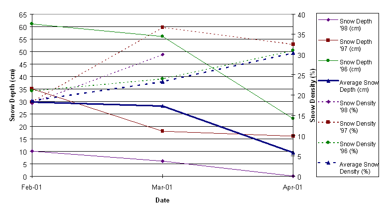
Figure 8: Snow characteristics at Puntzi Mtn. snow station (940 m, 28 years of record)
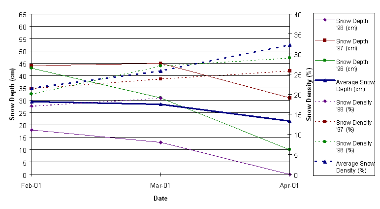
Figure 9: Snow characteristics at Nazko snow station (1070 m, 21 years of record)
5.2 Habitat Selection with Elevational Changes
In the first year of monitoring, the caribou used winter habitat in two different ways; some wintered in the alpine and some wintered in the forest. In the winter of 1997-98, only one radio-collared caribou used the strategy of wintering in the alpine, otherwise all other radio-collared caribou in 1996-97 and 1997-98 wintered at low elevations within forested habitats. The alpine-dwelling and forest-dwelling caribou are separated throughout this report so comparisons can be made between the features of their chosen habitats in the mid-winter, late winter/early spring, and spring seasons, when these differences may be relevant. In the other seasons they are combined with their respective herds.
The forest-dwelling radio-collared caribou found in the Itcha-Ilgachuz area were at the highest elevations in the summer with about 60% of relocations at elevations greater than 1800m (Figures 10 and 11). Average weekly elevations showed that the forest-dwelling caribou gradually travelled down the mountain sides through the fall and early winter (Figure 12). In mid-winter and late winter/early spring, the elevational use was at the lowest of the year for the Itcha-Ilgachuz caribou, with the majority of radio-collared animals in the 1200-1600 m elevational range (>80%). In May, the elevations increased again as some forest-dwelling caribou moved into the upper ESSF and AT zones prior to calving.
The forest-dwelling radio-collared caribou found in the Rainbow Range area showed a similar pattern of elevational change throughout the year (Figures 13 and 14). However, in the summer and fall months, they were found at consistently greater elevations than the Itcha-Ilgachuz herd, with more than 80% of collared animals at elevations greater than 1800m in September. In the winter, they were found at lower elevations than the Itcha-Ilgachuz caribou, predominantly in the 1000-1200m elevational range.
The winter alpine-dwelling caribou remained at high elevations for the duration of early-winter to spring (Figures 12 and 15). In Figure 12, the early winter use was only represented by one caribou from 1997-98, therefore no standard deviations were associated with those points. Early winter data was not collected from the 1995-96 alpine-dwellers, as that was the season in which they were originally collared. The majority of these alpine-dwelling animals were found in the 1800-2000 m elevational range in both the Itcha and Ilgachuz Mountains. In May, there was a small decrease in the average elevation as some individuals moved into the MS zone on their migration from the Ilgachuz Mountains winter range to calving grounds in the Rainbow Mountains.
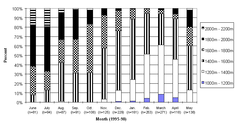
Figure 10: Percentage of winter forest-dwelling radio-collared caribou locations in each 200 meter elevational band by month for the Itcha-Ilgachuz Mountains herd
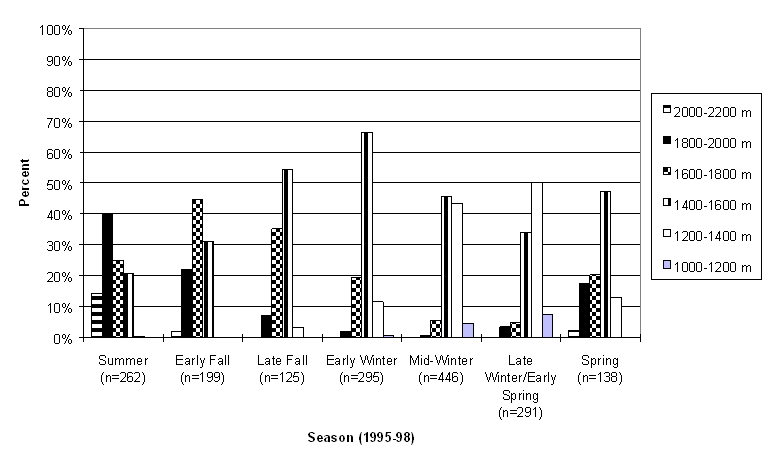
Figure 11: Percentage of winter forest-dwelling radio-collared caribou locations in each 200 meter elevational band by season for the Itcha-Ilgachuz Mountains herd
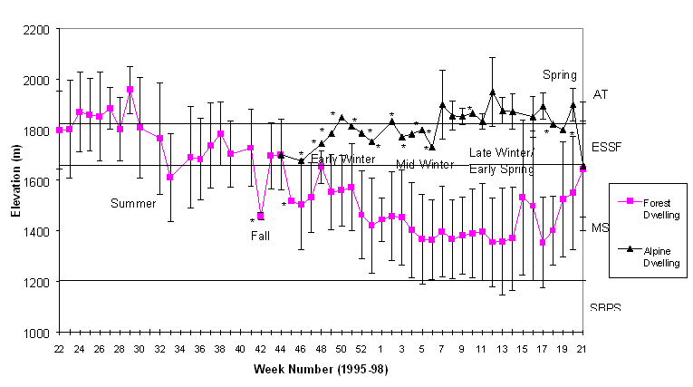
Figure 12: Mean elevation (+/- 1 standard deviation) of radio-collared caribou locations by week. The Forest-Dwelling class includes data from both the Itcha-Ilgachuz and Rainbow Mountains herds.
* these points are associated with a very small sample size
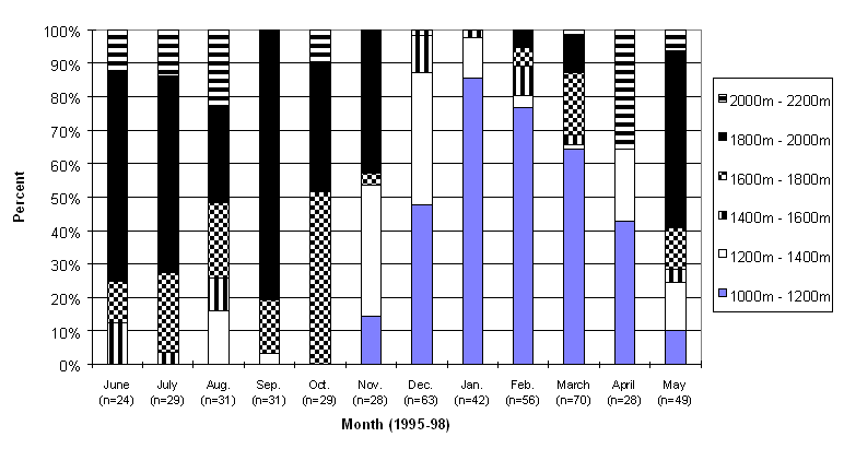
Figure 13: Percentage of winter forest-dwelling radio-collared caribou locations in each 200 meter elevational band by month for the Rainbow Mountains herd
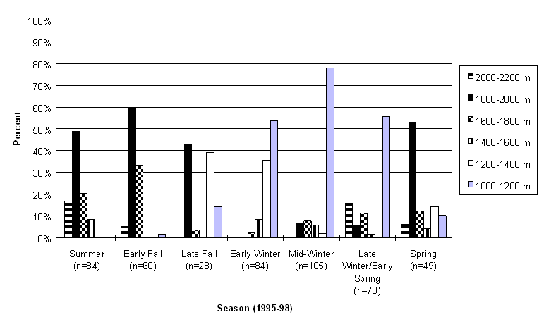
Figure 14: Percentage of winter forest-dwelling radio-collared caribou locations in each 200 meter elevational band by season for the Rainbow Mountains herd
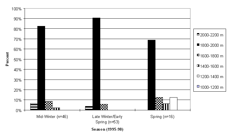
Figure 15: Percentage of winter alpine-dwelling radio-collared caribou locations in each 200 meter elevational band by season
5.3 Habitat Selection and Slope
The use of different slope categories by the three groups of caribou is represented in Figures 16 through 18. Throughout the year, winter forest-dwelling radio-collared caribou from the Itcha-Ilgachuz herd spent over 50% of their time in habitats with 10% or less slope. In the late fall through the winter, this percentage increased to around 90%. They were found on the greatest slopes in the summer, with 30% of the animals on slopes greater than 20%.
The winter forest-dwelling radio-collared caribou from the Rainbow Mountains herd also spent the majority of their time in habitats of 10% or less slope. However, their annual trends showed more seasonal variation. In the summer and early fall, caribou were found on relatively steep slopes, but this gradually decreased to a low of 2% in the early winter. Although the winter forest-dwelling caribou were most often in areas with little or no slope during the year, in almost every season there was at least a small representation on steeper slopes.
Winter alpine-dwelling caribou were found in locations with steeper slopes than the forest-dwellers, with less than 50% using slopes of 10% or less through the winter and spring seasons.
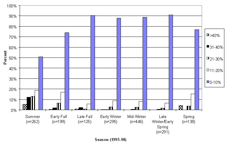
Figure 16: Percentage of winter forest-dwelling radio-collared caribou locations in each slope category by season for the Itcha-Ilgachuz Mountains herd
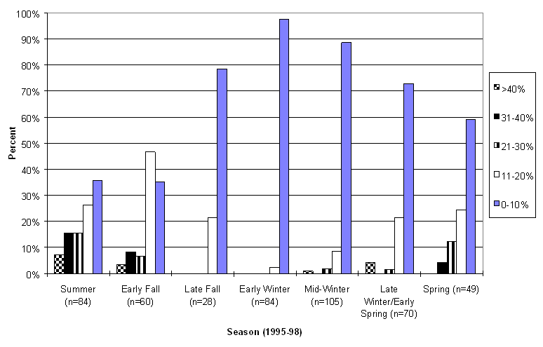
Figure 17: Percentage of winter forest-dwelling radio-collared caribou locations in each slope category by season for the Rainbow Mountains herd
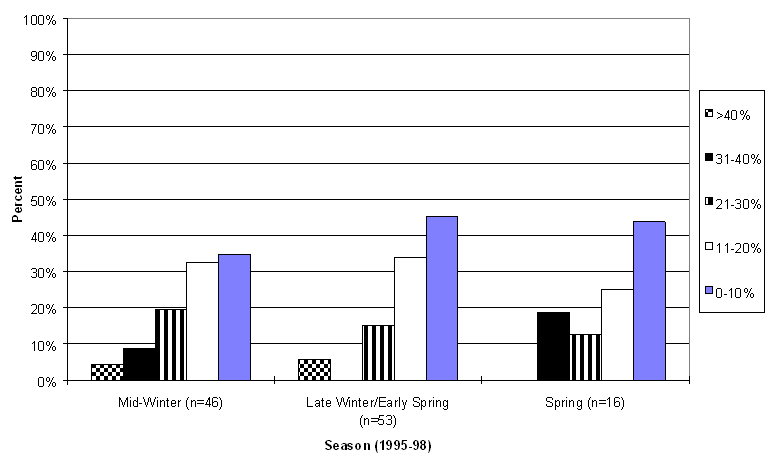
Figure 18: Percentage of winter alpine-dwelling radio-collared caribou locations in each slope category by season
5.4 Habitat Selection and Aspect
The use of different aspects by radio-collared caribou is represented in Figures 19 through 21. Radio-collared winter forest-dwelling caribou from the Itcha-Ilgachuz herd were found in all aspect categories throughout the year. Little variation was shown, except for a very slight preference for northerly aspects.
The winter forest-dwelling Rainbow Mountains herd showed more evidence of utilising particular aspects. In the early fall, the use of the north-east aspect is at a low of 12%, and it increases to a high in early winter at 41% and then gradually declines again. In the seasons when the north-east use is lower (early fall, late fall, late winter/early spring and spring), the use of north-west aspects increases. In the summer there appears to be no preference for particular aspects.
The winter alpine-dwelling caribou were found in habitats represented by all aspects in the mid-winter. In the late winter/early spring and spring, they had a slight preference for west and north-westerly aspects.
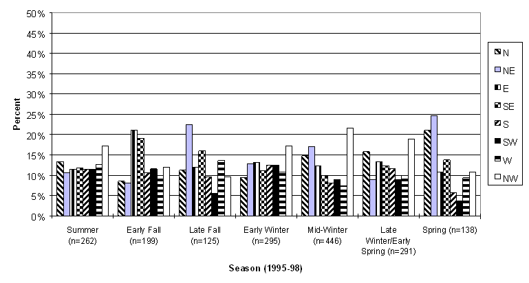
Figure 19: Percentage of winter forest-dwelling radio-collared caribou locations in each aspect by season for the Itcha-Ilgachuz Mountains herd
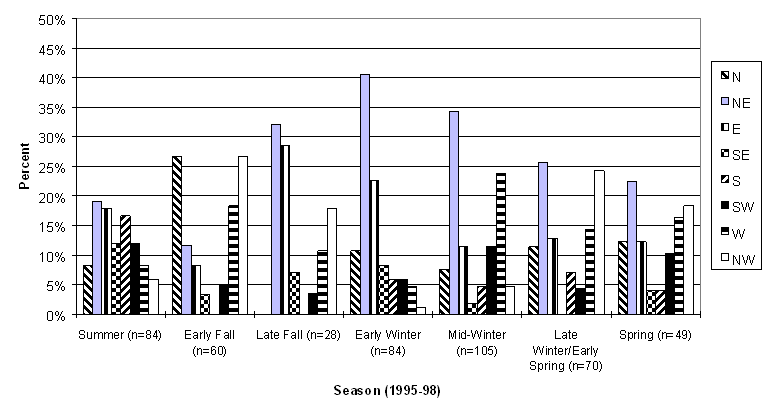
Figure 20: Percentage of winter forest-dwelling radio-collared caribou locations in each aspect by season for the Rainbow Mountains herd
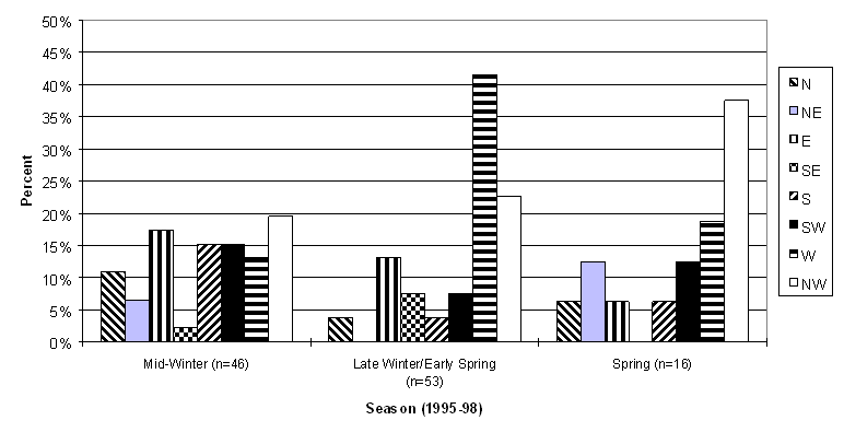
Figure 21: Percentage of winter alpine-dwelling radio-collared caribou locations in each aspect by season
5.5 Biogeoclimatic Zone Use
The percentage of winter forest-dwelling and winter alpine-dwelling caribou found in each biogeoclimatic sub-zone is represented in Figures 22 through 27. The Itcha-Ilgachuz herd predominantly used the Alpine Tundra (AT) zone during the summer and early fall (82% in June), but they moved down into the MS for the winter and spring months (90% in February). There was little use in the other forested units; the various sub-zones of the SBPS.
The Rainbow herd had more radio-collared animals in the AT (94% in July) than the Itcha-Ilgachuz herd, and for a longer period. They spent the majority of the summer, early fall, and additionally the late fall and spring in the AT. They wintered in the SBPS (especially the xc sub-zone) more than the Itcha-Ilgachuz herd, with use peaking in the mid-winter (up to 68% in February).
During winter, alpine-dwelling caribou were predominantly found in the AT zone. Approximately 25% of the radio-collared animals that wintered in the alpine descended into the ESSFxv and MSxv sub-zones in the spring (May).
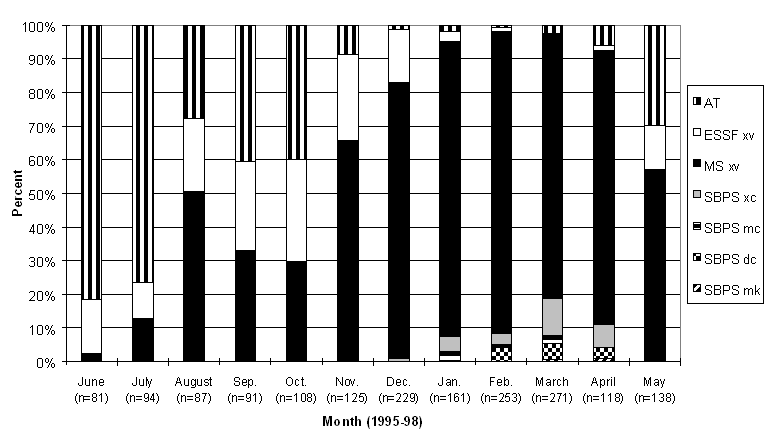
Figure 22: Percentage of winter forest-dwelling radio-collared caribou in each biogeoclimatic sub-zone by month for the Itcha-Ilgachuz Mountains herd
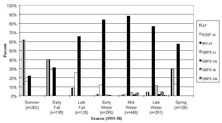
Figure 23: Percentage of winter forest-dwelling radio-collared caribou in each biogeoclimatic sub-zone by season for the Itcha-Ilgachuz herd
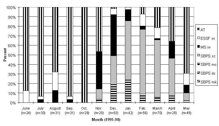
Figure 24: Percentage of winter forest-dwelling radio-collared caribou in each biogeoclimatic sub-zone by month for the Rainbow Mountains herd
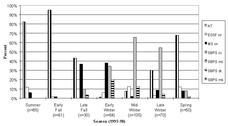
Figure 25: Percentage of winter forest-dwelling radio-collared caribou in each biogeoclimatic sub-zone by season for the Rainbow Mountains herd
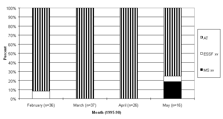
Figure 26: Percentage of winter alpine-dwelling radio-collared caribou in each biogeoclimatic sub-zone by month
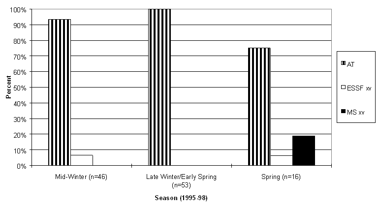
Figure 27: Percentage of winter alpine-dwelling radio-collared caribou in each biogeoclimatic sub-zone by season
5.6 Caribou Habitat Type Use
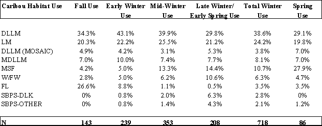
As the majority of caribou relocations during summer were at high elevations outside the area of existing habitat mapping, no habitat type use data is presented for this season. In addition, most relocations for the winter forest-dwelling Rainbow Mountains herd caribou were outside areas mapped into habitat units, therefore they were not included in this summary. This is also true for winter alpine-dwelling caribou, thus they were excluded from this section of analysis as well.
There was a decrease in Fescue-Lichen (FL) meadow use over the 3 years of monitoring in the fall, from 52.9% in 1995, to 21.7% in 1996, to only 15.9% in 1997 (Tables 1-3). Instead of FL habitat use in the fall seasons of 1996 and 1997, there was an increase of use in Dry Lichen/Lichen Moss (DLLM) and Lichen Moss (LM) sites. These habitats were also the most heavily used in winter, although in 1995-96 there was also some use of Moss/Seepage Forests (MSF; 18.7%).
In spring there was a shift from drier forested habitats to wetter sites resulting in an observed increase in the use of MSF sites. Although there was an increase in MSF sites during May, there was still substantial use of DLLM and LM sites, especially in 1997-98. Looking at overall use in the 3 years (Table 4), DLLM, LM, MSF, and FL sites were used the most (see Appendix 1 for description of caribou habitats).
Table 1: Percentage of forest-dwelling radio-collared caribou locations in each caribou habitat type by season in 1995-96 for the Itcha-Ilgachuz Mountains herd
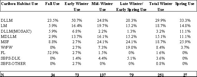
Table 2: Percentage of forest-dwelling radio-collared caribou locations in each caribou habitat type by season in 1996-97 for the Itcha-Ilgachuz Mountains herd
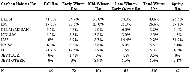
Table 3: Percentage of forest-dwelling radio-collared caribou locations in each caribou habitat type by season in 1997-98 for the Itcha-Ilgachuz Mountains herd
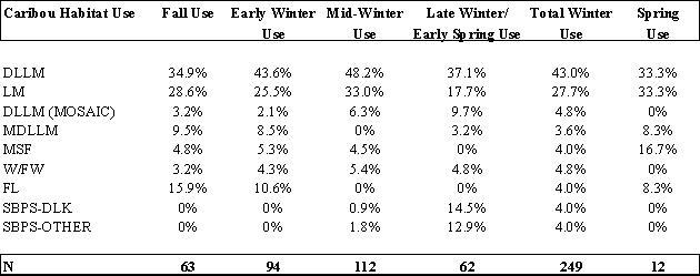
Table 4: Percentage of forest-dwelling radio-collared caribou locations in each caribou habitat type by season in 1995-98 for the Itcha-Ilgachuz Mountains herd
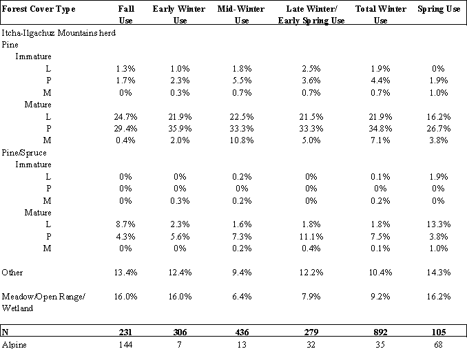
5.7 Forest Cover Type Use
As the majority of summer caribou relocations are within the alpine, use of forested sites for the summer season was not summarised in Tables 5 and 6.
The radio-collared caribou of the Itcha-Ilgachuz Mountains herd spent most of their time in mature pine stands throughout the year. They predominantly chose these stands on poor sites (up to 35.9% in the early winter), but also were in low quality sites around 20% of the time in all seasons. Immature stands of pine and pine/spruce were rarely used (>2.5%), and mature pine/spruce or other forest types were used less than 15% of the time in any season. Meadows, open range or wetlands were used to the greatest degree in the fall, early winter, and spring, at 16%.
The radio-collared caribou of the Rainbow Mountains herd also spent the majority of time in mature pine stands on poor quality sites (34.9% in early winter). However, they did not spend very much time in low quality sites. They too, did not have an affinity for immature stands of pine, or pine/spruce. However, they differed from the Itcha-Ilgachuz herd in the time they spent in mature pine/spruce stands on poor quality sites. Here they were found from 14.4% (mid-winter) to 26.3% (fall) of the time. In the fall, winter, and spring they spent a substantial amount of time in stands other than pine or pine/spruce, with a maximum in spring of 46.7% (n=15).
Table 5: Percentage of forest-dwelling radio-collared caribou locations in each forest cover type by season in 1995-98 for the Itcha-Ilgachuz Mountains herd
5.8 Habitat Selection and Stand Age
The majority (84-100%) of the forest cover age classes utilised by forest-dwelling caribou from the Itcha-Ilgachuz Mountains herd in every month of the year were class 5 or higher (80+ years; Figure 28). Age classes 8 and 9 (141-251+ years) were used most in the fall (Figure 29), although during all seasons they were used more than other age classes. Not satisfactorily restocked sites (NSR; recently logged areas) were used in August – May, in amounts less than 10% of the time.
Radio-collared caribou from the Rainbow herd also spent most of their time in stands greater than 81 years old (Figures 30 and 31). However, they used NSR sites to a greater degree, especially in March and May (late winter/early spring, and spring). The majority of this NSR use (16/18 collared animals in February, March, and May) was in the low snow year of 1997-98.
Table 6: Percentage of forest-dwelling radio-collared caribou locations in each forest type by season in 1995-98 for the Rainbow Mountains herd
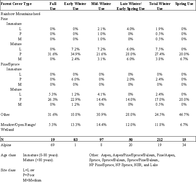
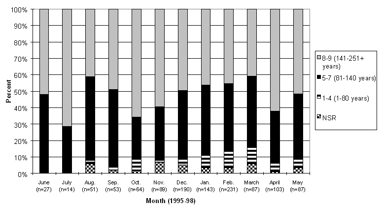
Figure 28: Percentage of forest-dwelling radio-collared caribou locations in each forest cover age class by month for the Itcha-Ilgachuz Mountains herd
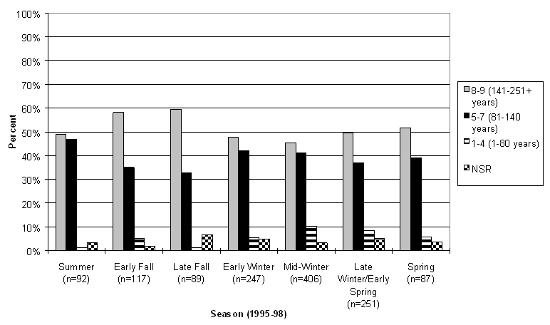
Figure 29: Percentage of forest-dwelling radio-collared caribou locations in each forest cover age class by season for the Itcha-Ilgachuz Mountains herd
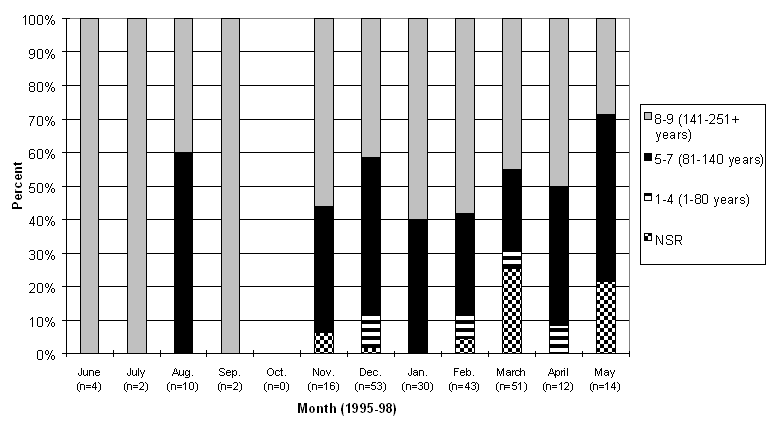
Figure 30: Percentage of forest-dwelling radio-collared caribou locations in each forest cover age class by month for the Rainbow Mountains herd
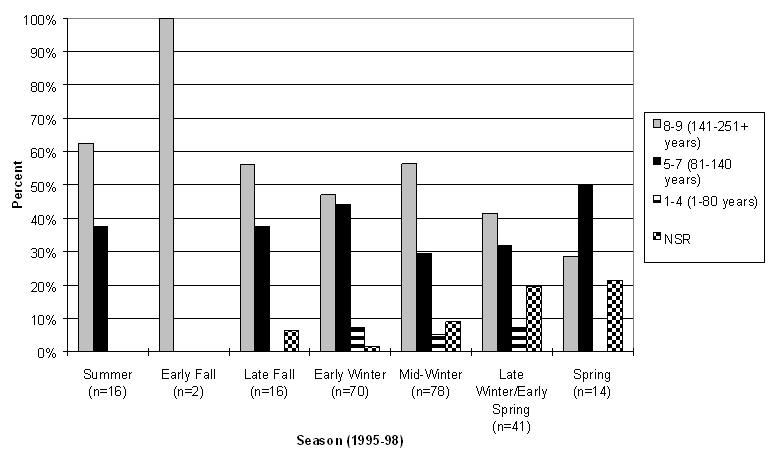
Figure 31: Percentage of forest-dwelling radio-collared caribou locations in each forest cover age class by season for the Rainbow Mountains herd
5.9 Habitat Use and Stand Crown Closure
The dominant crown closure category in every month for the radio-collared caribou from the Itcha-Ilgachuz Mountains herd included classes 4-5 (36-55%; Figure 31). Use of this crown closure category was highest during the late fall, with up to 62% of the caribou relocated in these stands (Figure 32). Summer months had smaller sample sizes than other months as data was only collected during this period in the second and third years of the project, and not all the relocations were found in forest sites that had crown closure information associated with them. Stands of 56-75% closure were also used throughout the year, with a low in June (4%) and a high in July (36%). Stands of category 0-1 (0-15%) were made up of logged sites as well as other stands that had minimal closure, and were used the most in the spring.
The Rainbow Mountains herd caribou were also found in crown closure classes 4-5 (Figures 33 and 34), to the greatest degree in the summer, fall, and spring. In the winter months, stands with high crown closure (classes 6 and 7) were used the most (66% in January). Categories 0-1 were used by this herd in mid to late winter and spring, corresponding with the NSR and young forest usage shown in Section 5.8.
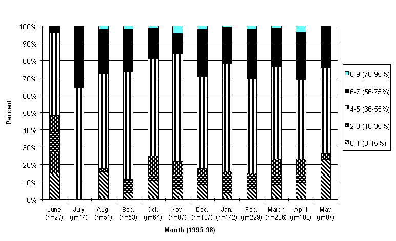
Figure 32: Percentage of forest-dwelling radio-collared caribou locations in each crown closure class by month for the Itcha-Ilgachuz Mountains herd
*Assumes all unlabelled NSR sites were recently logged (and therefore in category “0”)
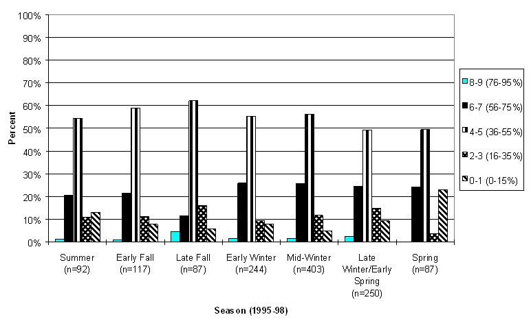
Figure 33: Percentage of forest-dwelling radio-collared caribou locations in each crown closure class by season for the Itcha-Ilgachuz Mountains herd
*Assumes all unlabelled NSR sites were recently logged (and therefore in category “0”)
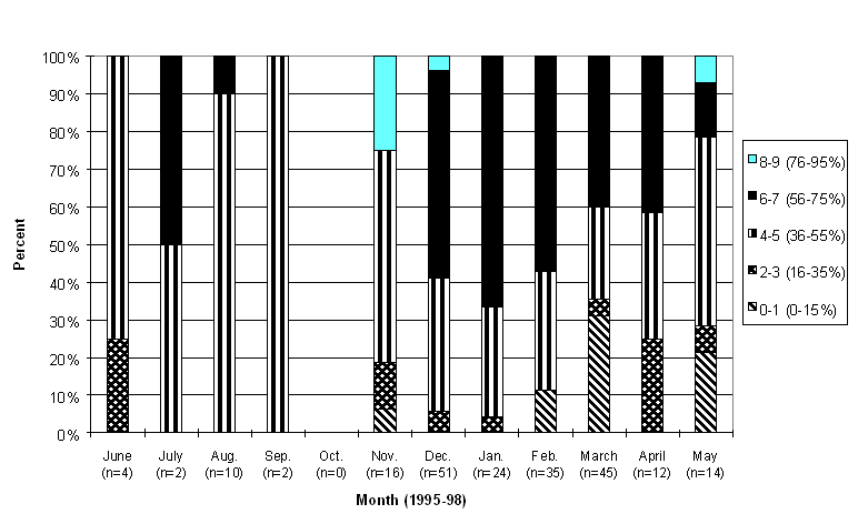
Figure 34: Percentage of forest-dwelling radio-collared caribou locations in each crown closure class by month for the Rainbow Mountains herd
*Assumes all unlabelled NSR sites were recently logged (and therefore in category “0”)
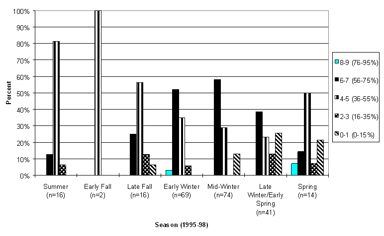
Figure 35: Percentage of forest-dwelling radio-collared caribou locations in each crown closure class by season for the Rainbow Mountains herd
*Assumes all unlabelled NSR sites were recently logged (and therefore in category “0”)
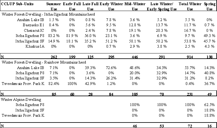
5.10 Park and CCLUP Sub-Unit Use
Radio-collared caribou from the Itcha-Ilgachuz herd spent the summer and early fall primarily in the Itcha-Ilgachuz Provincial Park (83%), and to a lesser degree in the surrounding Itcha-Ilgachuz Special Resource Development Zone (SRDZ; Table 7). In the late fall, they descended from the alpine and spent most of the winter in the Itcha-Ilgachuz SRDZ (at least 50% of the time) and spread throughout the other zones. In the spring, they began to move back up into the park again.
The Rainbow herd also summered in the alpine, but mainly within the confines of Tweedsmuir Provincial Park. When they began their descent in late fall, they dropped down into the surrounding Anahim Integrated Resource Management Zone (IRMZ) in the early winter. The entire winter use was divided between the Anahim IRMZ (54%), the Itcha-Ilgachuz SRDZ (31%), and the Itcha-Ilgachuz Provincial Park (15%).
The alpine-dwelling caribou spent almost all the winter months within the confines of the Itcha-Ilgachuz Provincial Park. In the spring, they were still mostly within this park, but some were also found in Tweedsmuir Provincial Park and the Itcha-Ilgachuz SRDZ.
Table 7: Percentage of winter alpine-dwelling and winter forest-dwelling radio-collared caribou in each CCLUP sub-unit by season in 1995-98
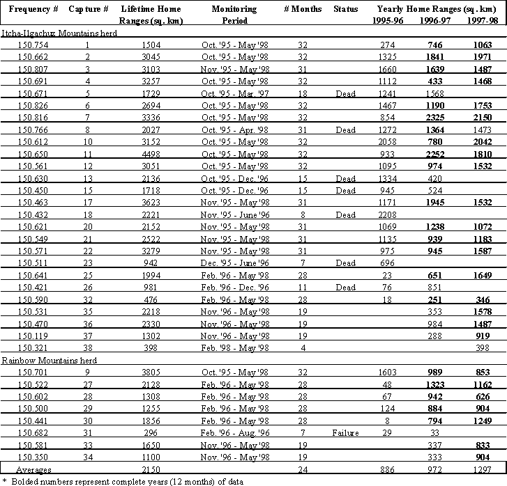
5.11 Home Ranges
Home ranges of the radio-collared caribou are shown in Appendix 2. The relocations were divided into summer (May-November) and winter (December-April) range, which are often separate and distinct areas. A map of all home ranges combined is located in Appendix 3. Most caribou range within a discrete area during each winter, but may not return to that same area the following year as illustrated by the yearly home range boundaries and Figures 5-7. The length of monitoring time varied for individual caribou as they were captured at different times and there were some mortalities and one collar failure, therefore the home range sizes were not all directly comparable (Appendix 4).
The Itcha-Ilgachuz Mountains portion of the population has been represented by 26 collared animals that have never been observed to cross to the west side of the Dean River, but easily move between the Itchas and Ilgachuz Mountains and their surrounding lowland areas. Yearly home ranges of Itcha-Ilgachuz radio-collared caribou with 12 consecutive months of monitoring had home ranges varying greatly from 251 sq. km to 2325 sq. km, with the average at 1357 sq. km (n=34). When Itcha-Ilgachuz caribou home ranges were compared between animals having 24 months of monitoring, home ranges again varied greatly from 597 sq. km to 4475 sq. km, with the average at 2720 sq. km (n=15).
The Rainbow Mountains portion of the population has been represented by 8 caribou which have either stayed completely on the west of the Dean River, or which have been observed to go as far east as Tundra Mountain in the Ilgachuz. The exceptions are caribou with the collar frequencies of 150.522 and 150.701 which have wandered more extensively east of the Ilgachuz even though they are predominantly Rainbow Range caribou. In this report caribou 150.701 was classified as an Itcha-Ilgachuz Mountains herd caribou for the monitoring year of 1995-96 and a Rainbow Mountains herd caribou for 1996-98. When Rainbow Mountains radio-collared caribou were compared, the average home range after 12 consecutive months of monitoring was 955 sq. km., ranging from 626-1323 sq. km (n=12). After 24 consecutive months of monitoring, this increased to 1945 sq. km., ranging from 1568-2485 sq. km (n=5).
6.0 DISCUSSION
6.1 Habitat Use and Seasonal Movements
Due to the date in which the monitoring of radio-collared caribou began, this summary is for data collected for two summers (1996 and 1997) and three winter periods (1995-96, 1996-97, and 1997-98). Three different seasonal strategies were observed in this one population of caribou, and have been separated throughout this report. The winter forest-dwelling caribou were made up of two herds; one that calved in the Rainbow Mountains and one that calved and resided in the Itcha-Ilgachuz Mountains and surrounding area. There was also a group of caribou that sometimes wintered in the alpine areas, instead of descending to lower elevation forests.
WINTER FOREST-DWELLING CARIBOU
Itcha-Ilgachuz Mountains herd
The Itcha-Ilgachuz Mountains herd calved in June, at an average elevation of 1975 m (Young and Shaw, 1998). They spent most of the rest of the summer at high elevations and within gently sloped alpine (AT). Most relocations were within the Itcha-Ilgachuz Provincial Park.
During the fall, caribou migrated from the high alpine calving grounds to lower elevation wintering habitat surrounding the Itcha and Ilgachuz Ranges. In the early fall, the caribou were still at relatively high elevations, descending from the AT and ESSF to the MSxv in the late fall. In the fall of 1995, there was high use of Fescue-Lichen meadows north and east of the Itcha Mountains. However, by December this use declined abruptly and was much less during the early winter period than reported by Cichowski (1993). In the fall seasons of 1996 and 1997, there was more use of the Dry Lichen/Lichen Moss and Lichen Moss forested habitats than in 1995, but still more use of Fescue-Lichen meadows than at any other time of the year. This annual shift from open meadow habitats to forested habitats was likely triggered by an overall increase in snow accumulation during the late fall/ early winter period (Cichowski 1993).
For the winter of 1995-96, caribou primarily used either dry or wet forested sites. There was less observed use of DLLM habitats and an increase in use of Moss/Dry Lichen/Lichen Moss and Moss/Seepage Forest habitats as compared to observed use in the mid 1980’s. Accompanied by this variation in habitat use was a shift in the predominant wintering area for the majority of the Itcha-Ilgachuz caribou. Snow levels may have contributed to this shift in use, because as noted in Section 5.1, mid-winter snow depths were above average, particularly in the southern part of the winter range. This may have influenced the unusually high degree of use in the northern portion of the winter range in the vicinity of the headwaters of the Coglistiko and Baezaeko Rivers (Figure 6). This area is dominated by wetter habitat units, thus the deeper than average snow levels observed throughout the winter range may have resulted in caribou seeking out habitat types with a higher abundance of arboreal lichens rather than drier sites with terrestrial lichens buried deep under the snow. This area is also influenced by its geographical proximity to the Itcha and Ilgachuz Mountains and their associated winter weather patterns, which may have provided some form of a snow shadow. To further contrast winter use, in the late winter of 1995-96, only 5.1% of the caribou locations were found within lower elevation SBPS Dry Lichen/Kinnikinnick sites whereas Cichowski (1993) observed 29.0% use of these sites during the same season in the mid-1980’s.
During the winter of 1996-97, there was a shift to using drier stands more frequently, with over 60% of relocations in the DLLM or LM habitats. Both of these habitat types had an increase of use from 1995-96, while MSF and MDLLM site usage decreased. New wintering areas were again observed, as caribou were found both north and south of the Itcha Mountains (Figure 6). The majority of the radio-collared caribou did not shift to the southern part of the winter range, even though snow station data suggested snow depths there were well below average and in the northern part of the winter range snow depths were well above average.
In the winter of 1997-98, radio-collared caribou showed caribou habitat use very similar to 1996-97. As a result, DLLM sites were used 43.0% of the time, and LM sites 27.7% of the time (43.6% and 26.6% respectively in 1996-97). The wintering area in 1997-98 was a combination of previously observed wintering areas (Figure 7). Itcha-Ilgachuz caribou were found mostly south of the Itchas or around them from Whitetop Mountain, around Satah Mountain, and down to Puntzi River. Snow depths were very low, thus caribou appeared not to be restricted in their movements throughout their winter range. It appears that in years where snow may prevent forested sites containing terrestrial lichens (DLLM, LM) from being utilised, because of depth or density, there is an increase in wetter sites being used, as in 1995-96. In that event, arboreal lichens may play a more substantial role in the caribou diet. When snow does not seem to be an impediment, the caribou chose drier sites with more terrestrial lichens, as in 1996-98 and the 1980’s (Cichowski, 1993).
Throughout the three winters, the Itcha-Ilgachuz Mountains caribou generally utilised mature (>80 years) moderately closed (>36% crown closure) pine stands on poor quality sites. These stands were generally located on flat terrain (<10% slope) in the mid elevations (1200-1600 m) of the MSxv biogeoclimatic zone. Caribou spent over 50% of their time in the Itcha-Ilgachuz Special Resource Development Zone, and the rest divided among the other CCLUP sub-units.
In May, the majority of collared caribou migrated back towards the calving grounds, following the receding snowline up into the Itcha and Ilgachuz Mountains, through forested habitats within the Shag, Pan and Carnlick Creeks. The greatest number of relocations in cutblocks were found in the spring, possibly because snow melted faster in these open sites and allowed easier access to forage.
Rainbow Mountains herd
The radio-collared caribou of the Rainbow Mountains herd calved then spent their summers in the alpine (AT) of the Rainbow Range, on relatively steep, high elevation slopes (>1800 m) in Tweedsmuir Park.
During the early fall, caribou were still found on sloping alpine and at the highest elevations of the year. They then started their descent from Tweedsmuir Park to the surrounding Anahim Lake IMZ and Itcha-Ilgachuz SRDZ in the late fall through mature pine, pine/spruce and other stands, bringing them into the MSxv, SBPSxc, and SBPSmc biogeoclimatic zones.
In 1995-96, Rainbow caribou wintered on the north side of the Ilgachuz Mountains in the alpine, so there were no winter forest-dwellers. In the winters of 1996-97 and 1997-98, the caribou were found in the lower elevation forest of the Dean River valley. In winter, Rainbow herd caribou were generally in mature (>80 years), close-canopied (>56%) mature pine or mature pine/spruce on poor sites. These stands were generally located in the Anahim Lake IMZ or the Itcha-Ilgachuz SRDZ. These sites were relatively flat (<10%) and at low elevations (>1200 m) areas, predominantly within the SBPSxc biogeoclimatic zone.
In the spring, the caribou began returning to higher elevation alpine calving grounds, generally on the northerly side of the Rainbow Range. In the spring, the Rainbow herd was also found to a higher degree in recent cutblocks, although they were also found there in March.
WINTER ALPINE-DWELLING CARIBOU
Habitat use patterns for winter alpine-dwelling caribou were included in either the Itcha-Ilgachuz herd or Rainbow herd during the summer, fall, and early winter seasons. During the rest of the winter and spring, habitat use information was summarised separately. Caribou were found on the north side of the Ilgachuz Mountains in 1995-96, and the north side of the Itcha Mountains in 1997-98. Habitat use was at high elevations (1800-2000 m) and predominantly on gentle slopes (20% or less), in the alpine (AT) of the Itcha-Ilgachuz protected area. Areas of use had shallow snow depths due to the exposure to prevailing winds. Areas and years with no use appeared to have deeper snow that would have made cratering for lichens more difficult. In the spring of 1996, some of the caribou that wintered on the north side of the Ilgachuz migrated across the Dean River towards calving grounds in the Rainbow Mountains.
6.2 Future Directions
Monitoring of radio collared caribou will continue at least until the end of the winter of 1998/99. Over the next year the availability of habitat will be quantified utilising GIS. This will include quantifying attributes of topography, forest types, caribou habitat units and soon to be completed TEM units. TEM ground work has been completed, and the final product is expected to be returned in early 1999. Habitat use and availability analysis will be completed following techniques developed by Neu et al. (1974) to determine if use of some attributes varies significantly from availability. This data will be utilised to develop a caribou habitat suitability model for the area that will be used in refining ‘no harvest’ and ‘modified harvest’ areas for the study area.
7.0 LITERATURE CITED
BC Government. 1996. 1996 caribou strategy report. Cariboo-Chilcotin Land-Use Plan caribou strategy committee. 50 pp.
BC Ministry of Forests. 1987. Map of caribou habitat units of the Itcha and Ilgachuz areas. Cariboo Forest Region. Williams Lake, B.C.
Cichowski, D.B. 1993. Seasonal movements, habitat use, and winter feeding ecology of woodland caribou in west-central British Columbia. B.C. Ministry of Forests, Land Management Report No. 79. 54 pp.
Hatler, D.F. 1987. Perspectives on Inventory of Caribou in British Columbia. Ministry of Environment and Parks. Victoria, B.C.
Neu, C.W., D.R. Byers, and J.M. Peek. 1974. A technique for analysis of utilisation-availability data. J. Wildl. Manage. 38:541-545.
Young, J.A. and Shaw, K.L. 1998. Summary of the 1997 Post Calving and Rut Surveys and the Late 1998 Winter Survey for the Itcha, Ilgachuz and Rainbow Mountains, Cariboo Region. Unpublished Report, Wildlife Branch, Ministry of Environment, Lands and Parks. Cariboo Region, B.C.
Appendix 1: Caribou Habitat Types in the Itcha-Ilgachuz Study Area
| Caribou Habitat Type |
Description and associated polygon units |
| DLLM |
Dry Lichen/ Lichen Moss combination DL, DL/LM, DL//LM, LM/DL, LM//DL, DL//M |
| LM |
Lichen Moss -lichen moss pure and lichen moss dominant over moss |
LM, LM//M |