News/Reports
Acoustical Bathymetry of Race Rocks
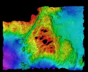
In February 1999 the hydrographic survey boat from The Institute of Ocean Sciences in Sidney, B.C. did an acoustical bathymetry program which mapped the seafloor around Race Rocks to a depth of 100 meters. The project was under the direction of James Galloway. This project will eventually involve two other components as well, grab samples at 40 locations underwater and underwater towed video to a depth of 20 meters.
Link to the reference https://racerocks.ca/mapscharts-racerocks/

In this view, the black area is either where land is located, or it represents the margins of the survey . (2d capture of entire area from south – 1 x magnification ). Bentick Island appears at the top of the picture. Great Race Rocks, where the light station is located is the large island in the center of the picture. Shoreline margins are not yet accurate. The present boundaries of the Ecological reserve are more or less the outer limits of the red area at 36 meters.
